


Get to know Luotian County
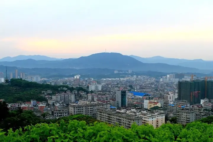
Photo adjustments
Full frame retained; resized proportionally to a maximum dimension of 960 pixels and converted to WebP quality 88. No crop, retouch, generated elements, or subject alteration. Final website rendition: full frame retained, proportionally resized to at most 720 pixels and converted to WebP. No additional retouching or subject alteration. Card displays may crop the view.
- Administrative area
- County · 县
- Part of
- Huanggang
- Chinese name
- 罗田县
- Local areas
- County guide
Area & population
- Area in the source
- 2,144.00 km²
- Population · 2020
- 473,195
Source: cited geographic source, as of the dates shown.
Setting and landscape
Tiantangzhai (天堂寨), 1,729.13 metres, rises where Luotian and Yingshan County (英山县) meet Jinzhai County (金寨县) in Anhui. It is the second-highest peak of the Dabie range and is sometimes treated as its main peak; it lies on the watershed between the Yangtze and the Huai and was called Yunshan (云山), "cloud mountain", in the Tang and Song. The county government gives forest cover of 72.4 percent and lists the Dabie Mountains world geopark, the Dabie Mountains National Forest Park and Tiantang Lake National Wetland Park (天堂湖) within the county.
History
Luotian has been a county for more than 1,500 years. The county government names among its people the Ming physician Wan Mizhai (万密斋), known as a "sage of medicine", Yu Sansheng (余三胜), regarded as a founder of Peking opera, the scholar Wang Baoxin (王葆心) and Xu Shouhui (徐寿辉), emperor of the Tianwan (天完) regime. The county was one of the main battlefields when the army of Liu Bocheng and Deng Xiaoping pushed into the Dabie Mountains.
What to see
Visitors come for Tiantangzhai, in Jiuzihe town (九资河镇), whose Luotian side is the Dabie Mountains National Forest Park; for Bodaofeng (薄刀峰) National Forest Park; and for the hot springs at Sanlifan (三里畈). A rare climbing plant, Cynanchum hubeiense (湖北豹药藤), is known only from Bodaofeng, where fewer than ten plants have been found. The county has two 4A and ten 3A scenic areas.
Food and local products
The county government calls Luotian a national home of chestnuts, poria (茯苓, a medicinal fungus), sweet persimmons, Dabie black goats and wild orchids, and says it has nine national geographical indication products. It lists Luotian chestnuts (罗田板栗), the black goats and local medicinal herbs among the mainstays of its farm economy.
Getting oriented
The county seat is Fengshan town (凤山镇). Two national highways and seven provincial roads cross the county, which has five expressway exits. The county government says Luotian is the only county in China with three pumped-storage power stations.
Highlights
- Tiantangzhai 天堂寨: 1,729.13-metre peak on the Hubei–Anhui border, second-highest in the Dabie range.
- Bodaofeng 薄刀峰: Forest park peak and the only known home of the plant Cynanchum hubeiense.
- Sanlifan hot springs 三里畈: Hot springs near Sanlifan, one of the county's main visitor destinations.
- Luotian chestnuts 罗田板栗: A mainstay of the county's farm economy; Luotian is called a national home of chestnuts.
Sources for this guide
罗田概况 · Luotian County People's Government
罗田县 - 维基百科 · Wikipedia (Chinese) · CC BY-SA 4.0
天堂寨 - 维基百科 · Wikipedia (Chinese) · CC BY-SA 4.0
Luotian County - Wikipedia · Wikipedia (English) · CC BY-SA 4.0
湖北豹药藤 - 维基百科 · Wikipedia (Chinese) · CC BY-SA 4.0
Original English written from the listed sources and checked sentence by sentence against quoted extracts by a separate reviewer. Updated 2026-09-24.
Explore Luotian County
Core places to explore, with English and Chinese names.
Places to explore around Luotian County
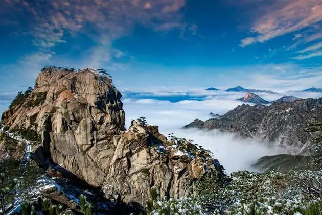 Tiantangzhai Mountain Hubei Side · 天堂寨湖北侧
Tiantangzhai Mountain Hubei Side天堂寨湖北侧
Tiantangzhai (天堂寨) is the highest summit of the Dabie Mountains at 1,729.13 metres, and this entry covers its Hubei flank in Luotian County, in the Huanggang area of eastern Hubei, where the peak forms one of the five scenic areas of the Dabie Mountain National Forest Park.
Read the place guide → AI illustration · AI 示意图(仅供参考,非该地点实拍)
Baodao Peak薄刀峰
Baodaofeng (薄刀峰) is a narrow rock ridge in the Dabie Mountains of Luotian County, in the Huanggang area of eastern Hubei, whose name - 'thin-blade summit' - comes from the knife-edged crest of Wolonggang that runs west from the peak.
Read the place guide →Plan your visit
Getting there
Luotian County is about 60 km in a straight line from central Huanggang. Search for 罗田县 in a map app to find stations and your accommodation.
Where to stay →Build your route
Tiantangzhai Mountain Hubei Side and Baodao Peak are both listed here. The linked place guides have entrance and visit details.
Continue with Huanggang →More in Huanggang
Sources & geographic information
Administrative names and parent areas: Official geographic directory · Reference date 2026-09-06.
Some facts checked against 罗田县 — Wikipedia contributors, CC BY-SA 4.0.
Some facts checked against 天堂寨 — Wikipedia contributors, CC BY-SA 4.0.
Some facts checked against Luotian County — Wikipedia contributors, CC BY-SA 4.0.
Some facts checked against 湖北豹药藤 — Wikipedia contributors, CC BY-SA 4.0.
Photo: Tiantangzhai Mountain Hubei Side · Source photographer · License not provided. EXIF orientation normalized; resized without changing aspect ratio; converted to WebP. No subject edits.
Map data © OpenStreetMap contributors. Pins mark approximate centres, not entrances or boundaries.