


Get to know Tongshan County

Photo adjustments
The exact downloaded source bytes are separately retained and hashed. Prepared JPEG is proportionally reduced to a maximum 720-pixel long edge; full frame retained, no subject alteration. Final website rendition: full frame retained, proportionally resized to at most 720 pixels and converted to WebP. No additional retouching or subject alteration. Card displays may crop the view.
- Administrative area
- County · 县
- Part of
- Xianning
- Chinese name
- 通山县
- Local areas
- County guide
Area & population
- Area in the source
- 2,413.00 km²
- Population · 2020 census
- 391,311
Source: cited geographic source, as of the dates shown.
Setting and landscape
The Mufu range stretches about 150 kilometres along the southern border with Jiangxi, with more than ten peaks above 1,000 metres; the county's highest point, Laoyajian (老鸦尖) on Taiyang Mountain (太阳山), reaches 1,656.7 metres. Damu Mountain (大幕山) lies across the north, and between the two ranges are hills and basins. Five main rivers, among them the Tongyang River (通羊河), drain into the Fushui Reservoir (富水水库) in the east of the county. The county seat, Tongyang (通羊镇), lies 37 kilometres southeast of the Xianning city government and 124 kilometres from Wuhan.
History
Tongshan County was split from Yongxing County (永兴县) in 964 under the Song, with its seat at Tongyang; according to Chinese Wikipedia, the name combines one character each from the older Qingshan (青山镇) and Tongyang towns. The Chinese Wikipedia article on Jiugong Mountain records that the Song Taoist Zhang Daoqing (张道清) built three halls and twelve courtyards on the mountain in 1187. Tongshan is also one of the places that claim the grave of Li Zicheng (李自成), leader of the late-Ming peasant rebellion; the Tongshan tomb is a national key protected heritage site, although where he died is still disputed.
What to see
Jiugong Mountain, a national nature reserve and AAAA scenic area in the middle section of the Mufu range, has a 1,656-metre main peak. Chinese Wikipedia describes its Yunzhong Lake (云中湖) as the largest alpine lake in Hubei and lists waterfalls, including the Dayatou Falls (大崖头瀑布) with a drop of more than 400 metres. Within the reserve are the Yunguan cliff inscriptions (云关摩崖石刻), a provincial heritage site listed in 2025, and the Lijiapu battlefield site (李家铺古战场遗址); the Li Zicheng tomb scenic area (闯王陵) at the western foot of the mountain is rated AAA.
Yinshui Cave (隐水洞) in Dafan town (大畈镇) is an AAAA scenic area classed by the county culture and tourism bureau as a geological landform site.
Food and local products
Cikou hollow noodles (慈口空心面), first made at the Zhu Yuesheng (朱月胜) noodle shop in 1853, are long thin noodles pierced through by hand during kneading and do not turn the broth pasty even when reboiled. Dafan sesame cakes (大畈麻饼) combine flour, sesame, tea oil, rock sugar, raisins and dried tangerine peel, and are steamed, smoked, baked and roasted. Yanxia smoked fish (燕厦熏鱼烤) is made from Fushui river fish. Tongshan wood carving (通山木雕), mainly relief work drawing on local Han opera and tea-picking opera stories, entered the national intangible heritage list in 2014.
Highlights
- Jiugong Mountain 九宫山: National nature reserve and AAAA scenic area in the Mufu range, main peak 1,656 metres.
- Li Zicheng Tomb 闯王陵: AAA scenic area; the Tongshan tomb of Li Zicheng is a national key protected site.
- Yinshui Cave 隐水洞: AAAA geological scenic area in Dafan town.
- Cikou hollow noodles 慈口空心面: Hand-pierced hollow noodles first made in 1853.
- Tongshan wood carving 通山木雕: Relief carving on national intangible heritage list since 2014.
Sources for this guide
通山县人民政府门户网站 - 地理位置 · Tongshan County People's Government
通山县人民政府门户网站 - 自然环境 · Tongshan County People's Government
通山县人民政府门户网站 - 名优特产 · Tongshan County People's Government
通山县A级旅游景区基础信息 · Tongshan County Culture and Tourism Bureau
通山县 - 维基百科,自由的百科全书 · Wikipedia (Chinese) · CC BY-SA 4.0
九宫山 - 维基百科,自由的百科全书 · Wikipedia (Chinese) · CC BY-SA 4.0
木雕(通山木雕) - 中国非物质文化遗产网·中国非物质文化遗产数字博物馆 · China Intangible Cultural Heritage Network
Original English written from the listed sources and checked sentence by sentence against quoted extracts by a separate reviewer. Updated 2026-09-24.
Explore Tongshan County
Core places to explore, with English and Chinese names.
Places to explore around Tongshan County
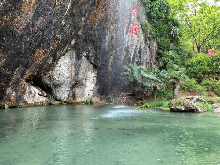 The rock-face entrance and pool of Yinshui Cave, Tongshan County · 通山县隐水洞地质公园,洞口与水潭 Source-recorded photograph date: 2019-04-26.
Yinshui Cave隐水洞
Yinshuidong (隐水洞) is a karst cave and geopark in Tongshan County, in the Xianning area of southern Hubei, formed in limestone country and carrying an underground river through its passages.
Read the place guide →Yunzhong Lake at Jiugong Mountain · 九宫山云中湖 Photograph date recorded by the source: 17 September 2024, 14:03:57.Jiugong Mountain九宫山
Jiugong Mountain rises above Tongshan with a high lake settlement, wooded ravines and exposed summit viewpoints. Yunzhong Lake is the practical centre for a mountain stay, while Tonggubao offers broad ridge views and Shilong…
Read the place guide →Plan your visit
Getting there
Tongshan County is about 30 km in a straight line from central Xianning. Search for 通山县 in a map app to find stations and your accommodation.
Where to stay →Build your route
Yinshui Cave and Jiugong Mountain are both listed here. The linked place guides have entrance and visit details.
Continue with Xianning →More in Xianning
Sources & geographic information
Administrative names and parent areas: Official geographic directory · Reference date 2026-09-06.
Some facts checked against 通山县 — Wikipedia contributors, CC BY-SA 4.0.
Some facts checked against 九宫山 — Wikipedia contributors, CC BY-SA 4.0.
Photo: Yinshui Cave · Hbysyg502 · CC BY-SA 4.0. Full frame retained; proportionally resized and converted to WebP. No retouching or changes to the photographed subject. Card displays may crop the view.

Photo: Jiugong Mountain · Ddayzzz · Ddayzzz — 九宫山云中湖景区.jpg — CC BY 4.0 · CC BY 4.0. The exact downloaded source bytes are separately retained and hashed. Prepared JPEG is proportionally reduced to a maximum 720-pixel long edge; full frame retained, no subject alteration. Final website rendition: full frame retained, proportionally resized to at most 720 pixels and converted to WebP. No additional retouching or subject alteration. Card displays may crop the view.

Map data © OpenStreetMap contributors. Pins mark approximate centres, not entrances or boundaries.