


Get to know Xian'an District
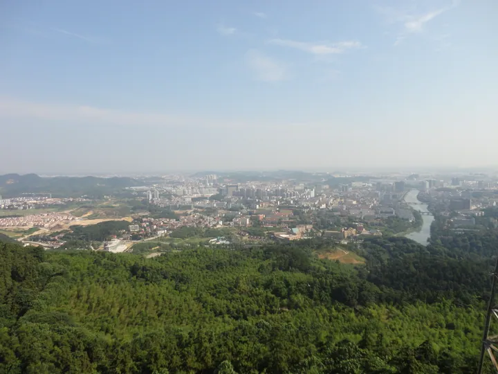
Photo adjustments
Full frame retained; proportionally resized and converted to WebP. No retouching or changes to the photographed subject. Card displays may crop the view.
- Administrative area
- District · 市辖区
- Part of
- Xianning
- Chinese name
- 咸安区
- Local areas
- District guide
Area & population
- Area in the source
- 1,503.08 km²
- Population · 2020 census
- 657,590
- Administrative seat
- Yong'an Subdistrict
Source: cited geographic source, as of the dates shown.
Setting and landscape
The land rises from the plain in the northwest to low mountains in the southeast. The highest point is Zaobeiyan (灶背岩) on Damu Mountain (大幕山), at 954.1 metres; the lowest lies beside Futou Lake (斧头湖) in the north. Limestone caves are common in the hills, and more than twenty have names, among them Taiyi Cave (太乙洞) and Feixian Cave (飞仙洞). The Gan River (淦河) is the only river that flows through the Xianning urban area. The low hills within the city mostly run northeast to southwest, roughly parallel to the Beijing–Guangzhou railway, and the Qianshan (潜山) and Xiangwu Mountain (香吾山) hills rise in the south of Wenquan (温泉街道).
History
A Yong'an town (永安镇) was created here in 768 under the Tang and became a county in 955. In 1007 it was renamed Xianning, taking the phrase 'all states at peace' (万国咸宁) from the Book of Changes, to avoid the name of the Song founder's Yong'an tomb. The county became a county-level city in 1983, and Xian'an District was formed when Xianning became a prefecture-level city in 1998, officially opening in 1999.
In August 1926 the National Revolutionary Army, with Ye Ting's (叶挺) Independent Regiment circling behind the lines, broke the warlord Wu Peifu's (吴佩孚) hold on Tingsiqiao (汀泗桥), where a single railway bridge was the only approach, opening the way to Wuhan. The Tingsiqiao battlefield became a national key protected site in 1988; trenches, gun emplacements and blockhouses survive on Tanao Hill (塔垴山), and a memorial hall opened in Tingsiqiao town in 2009.
What to see
The district government lists Taiyi Cave, the Xingxing bamboo sea (星星竹海), osmanthus gardens, hot springs, the Nanchuan Reservoir (南川水库), the Hesheng Bridge (贺胜桥) battlefield, and the underground military works known as Project 131. At Xiangyang Lake (向阳湖) is the former 'May Seventh' cadre school where more than 6,000 writers, including Bing Xin (冰心), Shen Congwen (沈从文) and Zang Kejia (臧克家), lived.
Food and local products
Xian'an is known as the home of osmanthus, moso bamboo, tea, ramie and hot springs. The centrepiece of local banquets, Xian'an pagoda pork (咸安宝塔肉), stacks fried olive-shaped balls of tofu, sweet-potato starch, puffed rice, minced pork and fish with slices of blanched, fried pork belly in four layers in a bowl, which is then steamed and finished with a sauce.
Highlights
- Tingsiqiao Northern Expedition Battlefield 北伐汀泗桥战役遗址: Site of the 1926 battle, national key protected site since 1988, with a memorial hall opened in 2009.
- Xiangyang Lake May Seventh Cadre School site 向阳湖五七干校旧址: Where more than 6,000 writers, including Bing Xin and Shen Congwen, lived.
- Taiyi Cave 太乙洞: One of the best-known of more than twenty named limestone caves in the district.
- Xian'an pagoda pork 咸安宝塔肉: Layered, steamed banquet dish of pork belly and fried tofu-and-meat balls.
Sources for this guide
咸安概况-咸安区人民政府 · Xian'an District People's Government
自然环境-咸安区人民政府 · Xian'an District People's Government
历史人文-咸安区人民政府 · Xian'an District People's Government
全国爱国主义教育示范基地-北伐汀泗桥战役遗址纪念馆-咸安区人民政府 · Xian'an District People's Government
精工匠制!央视《味道》栏目锁定咸安宝塔肉-咸安区人民政府 · Xian'an District People's Government
Original English written from the listed sources and checked sentence by sentence against quoted extracts by a separate reviewer. Updated 2026-09-24.
Explore Xian'an District
Core places to explore, with English and Chinese names.
Places to explore around Xian'an District
Plan your visit
Getting there
Xian'an District covers the centre of Xianning. Search for 咸安区 in a map app to find stations and your accommodation.
Where to stay →Build your route
Start with Qianshan National Forest Park. The linked place guides have entrance and visit details.
Continue with Xianning →More in Xianning
Sources & geographic information
Administrative names and parent areas: Official geographic directory · Reference date 2026-09-06.
Photo: Qianshan National Forest Park · xianning · CC BY-SA 3.0. Full frame retained; proportionally resized and converted to WebP. No retouching or changes to the photographed subject. Card displays may crop the view.

Map data © OpenStreetMap contributors. Pins mark approximate centres, not entrances or boundaries.