


Get to know Yizhang County
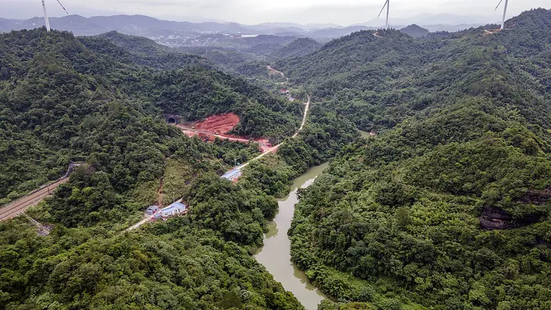
Photo adjustments
Full frame retained; EXIF orientation normalized, proportionally resized to at most 800 pixels and converted to WebP. No generated pixels or subject changes. Cards may crop the display.
- Administrative area
- County · 县
- Part of
- Chenzhou
- Chinese name
- 宜章县
- Local areas
- County guide
Setting and landscape
Yizhang borders Rucheng (汝城), Linwu (临武), Zixing (资兴) and Chenzhou's Beihu (北湖区) and Suxian (苏仙区) districts in Hunan, and Lechang (乐昌), Yangshan (阳山), Ruyuan (乳源) and Lianzhou (连州) in Guangdong. The county seat is Yuxi town (玉溪镇).
Mangshan sits where Hunan meets Guangdong, and takes its name from the pythons found there and its vast forest. It has a national forest park and a national nature reserve, and the Hunan provincial government describes it as the best-preserved primeval forest area at its latitude on Earth and a gene bank of southern China's plants and animals.
History
The county was carved out of southern Chen County (郴县) in 617, under the Sui dynasty, under the name Yizhang (义章). In 976 the name was changed to its present written form, Yizhang (宜章), to avoid a character in the personal name of the Song emperor Zhao Guangyi (赵光义), and it has been used ever since. In 1954 a State Council ruling on the Hunan–Guangdong border moved five villages formerly under Lechang in Guangdong into Yizhang.
What to see
Mangshan's Wuzhifeng (五指峰) section has a high-altitude lift that the head of the county's culture and tourism bureau compared with the space elevator in the film The Wandering Earth 2, and from 2017 the mountain was developed as China's first mountain scenic area designed to be barrier-free from start to finish. The county has also held a Yao ethnic culture week under the banner "Hospitable Mangshan".
The county's tourism plan groups its other sights as a hot spring, the former headquarters of the Xiangnan New Year Uprising (湘南年关暴动指挥部旧址), Chishi Bridge (赤石大桥) and Mangshan Lake (莽山湖). It adds five themed towns: a Yao ethnic town at Mangshan, a tea town at Tiantang (天塘), a hot-spring town at Yiliu (一六), a revolutionary-history town at Baishidu (白石渡) and an industrial-heritage mining town at Meitian (梅田).
Getting oriented
National Highways 107 and 240 cross the county.
Highlights
- Mangshan 莽山: Forested mountain at the county's southern tip on the Guangdong border, with a national forest park and a national nature reserve.
- Wuzhifeng scenic area 五指峰: Mangshan section with a high-altitude lift compared with the space elevator in The Wandering Earth 2.
- Former headquarters of the Xiangnan New Year Uprising 湘南年关暴动指挥部旧址: One of the named sights in Yizhang's tourism plan.
- Mangshan Lake 莽山湖: Lake listed alongside Mangshan in the county's tourism plan.
Sources for this guide
宜章县 - 维基百科,自由的百科全书 · Wikipedia (Chinese) · CC BY-SA 4.0
莽山 - 维基百科,自由的百科全书 · Wikipedia (Chinese) · CC BY-SA 4.0
【郴州市】宜章大莽山全域旅游出圈-湖南省人民政府门户网站 · Hunan Provincial People's Government
Original English written from the listed sources and checked sentence by sentence against quoted extracts by a separate reviewer. Updated 2026-09-24.
Explore Yizhang County
Core places to explore, with English and Chinese names.
Places to explore around Yizhang County
 Mangshan Mountain (
Plan your visit
Getting there
Yizhang County is about 40 km in a straight line from central Chenzhou. Search for 宜章县 in a map app to find stations and your accommodation.
Where to stay →Build your route
Start with Mangshan Mountain. The linked place guides have entrance and visit details.
Continue with Chenzhou →More in Chenzhou
Sources & geographic information
Administrative names and parent areas: Official geographic directory · Reference date 2026-09-06.
Some facts checked against 宜章县 — Wikipedia contributors, CC BY-SA 4.0.
Some facts checked against 莽山 — Wikipedia contributors, CC BY-SA 4.0.
Photo: Mangshan Mountain · 张元柏 · CC BY-SA 3.0. Full frame retained; EXIF orientation normalized, proportionally resized to at most 800 pixels and converted to WebP. No generated pixels or subject changes. Cards may crop the display.

Map data © OpenStreetMap contributors. Pins mark approximate centres, not entrances or boundaries.