


Get to know Yanfeng District
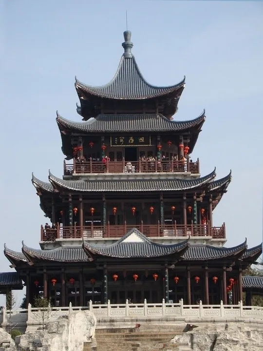
Photo adjustments
Full frame retained; proportionally resized and converted to WebP. No retouching or changes to the photographed subject. Card displays may crop the view.
- Administrative area
- District · 市辖区
- Part of
- Hengyang
- Chinese name
- 雁峰区
- Local areas
- District guide
History
The district was formed on 4 April 2001, when the State Council approved a redrawing of Hengyang's urban districts. The old Chengnan District (城南区), where Huiyan Peak stands, was abolished, and Yanfeng took over five of its subdistricts, most of two suburban townships and Wenchang township (文昌乡) from Hengnan County (衡南县). For the peak's name, 'Goose-Return Peak', the Hengzhou prefectural gazetteer gives two explanations: that wild geese fly no further south than Hengyang, or that the hill is shaped like a goose turning back. The same belief gave Hengyang its nickname Yancheng (雁城), 'Goose City'.
The Ming geographer Xu Xiake (徐霞客) visited in 1637 and wrote that the peak was not very high, with the Xiang to the east and the city to the north below it. After the Battle of Hengyang (衡阳保卫战) in 1944, when Japanese forces occupied the city, the old halls on the hill were burned down, leaving one temple gate and half a Buddha hall.
What to see
Huiyan Peak Tourist Area (回雁峰旅游区) was confirmed as a national 4A scenic area by Hunan's scenic-area rating committee on 30 September 2024; the hill is also a Hengyang municipal protected site. Its summit is 96.8 metres above sea level. The city government rebuilt Huiyan Peak Park between 1983 and early 1985. Yanfeng Temple (雁峰寺) on the hill was founded in the Southern and Northern dynasties and is a favourite place for Hengyang residents to pray at Spring Festival. The scenic area also takes in the 35-metre, four-storey Huiyan Pavilion (回雁阁), whose double eaves are shaped like a goose spreading its wings, and a square with a 10-metre goose sculpture that serves as the city emblem, entered through a gate inscribed 'First Peak of Nanyue' by Zhao Puchu (赵朴初).
Halfway up the west side, the Wang Chuanshan Birthplace Memorial Hall (王船山出生地纪念馆) is a grey-brick building in Ming and Qing style, its main block covering 101 square metres, displaying clogs, umbrellas and oil lamps beside the collected works of Wang Chuanshan (王船山).
Three sites on the Hunan provincial heritage list lie wholly or partly in the district: the Hengyang Anti-Japanese War Memorial Tower (衡阳抗战纪念塔), dated 1947; part of the group of Battle of Hengyang sites from 1944 to 1946, shared with Zhengxiang District; and part of Hengyang's early railway buildings from 1933 to 1956. The former Chuanshan Academy (船山书院旧址) is on the municipal list.
Highlights
- Huiyan Peak 回雁峰: A hill 96.8 metres above sea level, counted as the first of Mount Heng's 72 peaks; national 4A scenic area since 2024.
- Yanfeng Temple 雁峰寺: Buddhist temple on Huiyan Peak founded in the Southern and Northern dynasties.
- Huiyan Pavilion 回雁阁: A four-storey, 35-metre tower whose eaves are shaped like a goose spreading its wings.
- Hengyang Anti-Japanese War Memorial Tower 衡阳抗战纪念塔: Provincial protected site dated 1947.
Sources for this guide
雁峰区 - 维基百科,自由的百科全书 · Wikipedia (Chinese) · CC BY-SA 4.0
雁峰区各级文物保护单位列表 - 维基百科,自由的百科全书 · Wikipedia (Chinese) · CC BY-SA 4.0
回雁峰 - 维基百科,自由的百科全书 · Wikipedia (Chinese) · CC BY-SA 4.0
湖南省旅游景区质量等级评定委员会关于确定4家旅游景区为国家4A级旅游景区的公告 · Hunan Provincial People's Government portal (from the Hunan Department of Culture and Tourism)
Original English written from the listed sources and checked sentence by sentence against quoted extracts by a separate reviewer. Updated 2026-09-24.
Explore Yanfeng District
Core places to explore, with English and Chinese names.
Yanfeng District 雁峰区
Plan your visit
Getting there
Yanfeng District is about 7 km in a straight line from central Hengyang. Search for 雁峰区 in a map app to find stations and your accommodation.
Where to stay →More in Hengyang
Sources & geographic information
Administrative names and parent areas: Official geographic directory · Reference date 2026-09-06.
Some facts checked against 雁峰区 — Wikipedia contributors, CC BY-SA 4.0.
Some facts checked against 雁峰区各级文物保护单位列表 — Wikipedia contributors, CC BY-SA 4.0.
Some facts checked against 回雁峰 — Wikipedia contributors, CC BY-SA 4.0.
Map data © OpenStreetMap contributors. Pins mark approximate centres, not entrances or boundaries.