


Get to know Chenxi County
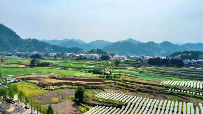
Photo adjustments
EXIF orientation normalized; resized without changing aspect ratio; converted to WebP. No subject edits.
- Administrative area
- County · 县
- Part of
- Huaihua
- Chinese name
- 辰溪县
- Local areas
- County guide
Area & population
- Area in the source
- 1,976.81 km²
- Population · 2010
- 453,565
- Administrative seat
- Chenyang
Source: cited geographic source, as of the dates shown.
Setting and landscape
The Yuan River runs 99.7 kilometres through the county and the Chen River 33.7 kilometres, meeting at the county town of Chenyang (辰阳镇). The highest point is the main peak of Mount Luozi (罗子山), at 1,378.7 metres. The county government describes the Yuan as navigable for 1,000-tonne vessels here, linking upstream to Guizhou and downstream to Dongting Lake and the Yangtze.
History
The old name was Chenyang (辰阳). Qu Yuan's poem Crossing the River (涉江) mentions spending a night at Chenyang. A county, Chenling (辰陵县), was set up here in 205 BC, in the second year of the Western Han founder, and renamed Chenyang three years later. In 589 the seat moved to the north bank of the Yuan at the mouth of the Chen River, and the county took the name Chenxi. The county government calls it the old industrial base of greater western Hunan, once known as the "coal capital of western Hunan" (湘西煤都).
Chenhe gaoqiang (辰河高腔), a local opera, and the Chashan haozi (茶山号子) work songs are on the national intangible heritage list. Most residents speak the Chenxu (辰溆片) variety of Xiang Chinese; the Yao are the largest ethnic minority, and the county has five Yao ethnic townships.
What to see
Dayou Mountain (大酉山) rises south of the old town of Chenyang, on the south bank of the Yuan. Local tradition places the grave of the sage Shan Juan (善卷) and a shrine to him on its Jiufeng ridge, and the Dayou caves are held to be where books were hidden from the Qin burning of books, the origin of the saying "书通二酉" ("well read as the two You caves"). On the riverside cliff facing the county town, the Danshan cliff inscriptions (丹山摩崖石刻) are more than ten carved poems and texts; the county government lists Liu Yuxi, Huang Tingjian, Zhu Xi, Wang Yangming, Lin Zexu and Shen Congwen among over thirty authors. Dayou Temple (大酉观), a Taoist site at the foot of the mountain rebuilt in 1608, became a county-level protected site in 1983.
Wubaotian (五宝田) is a national historical and cultural village, and Gongjiawan (龚家湾) a provincial one.
Getting oriented
Chenxi borders Yuanling County (沅陵县) to the north, Xupu County (溆浦县) to the east, Zhongfang County (中方县) and Hecheng District (鹤城区) to the south, and Mayang (麻阳) and Luxi (泸溪) to the west. The Shanghai–Kunming railway and National Highway 354 cross the county, as does the Loudi–Huaihua expressway.
Highlights
- Dayou Mountain 大酉山: Mountain on the south bank of the Yuan opposite the old town, tied to the legends of Shan Juan and of books hidden in its caves.
- Danshan cliff inscriptions 丹山摩崖石刻: More than ten poems carved on the riverside cliff, by authors from Liu Yuxi to Shen Congwen.
- Dayou Temple 大酉观: Taoist temple at the foot of Dayou Mountain, rebuilt in 1608; county-level protected site since 1983.
- Chenhe gaoqiang 辰河高腔: Local opera on the national intangible heritage list.
- Wubaotian 五宝田: Village listed as a national historical and cultural village.
Sources for this guide
辰溪概况 - 辰溪县人民政府 · Chenxi County People's Government
神秘的大酉山 - 辰溪县人民政府 · Chenxi County People's Government
辰溪县 - 维基百科,自由的百科全书 · Wikipedia (Chinese) · CC BY-SA 4.0
Original English written from the listed sources and checked sentence by sentence against quoted extracts by a separate reviewer. Updated 2026-09-24.
Explore Chenxi County
Core places to explore, with English and Chinese names.
Chenxi County 辰溪县
Plan your visit
Getting there
Chenxi County is about 50 km in a straight line from central Huaihua. Search for 辰溪县 in a map app to find stations and your accommodation.
Where to stay →More in Huaihua
Sources & geographic information
Administrative names and parent areas: Official geographic directory · Reference date 2026-09-06.
Some facts checked against 辰溪县 — Wikipedia contributors, CC BY-SA 4.0.
Map data © OpenStreetMap contributors. Pins mark approximate centres, not entrances or boundaries.