


Get to know Xinhua County

Photo adjustments
Full frame retained; proportionally resized and converted to WebP. No retouching or changes to the photographed subject. Card displays may crop the view.
- Administrative area
- County · 县
- Part of
- Loudi
- Chinese name
- 新化县
- Local areas
- County guide
Area & population
- Area in the source
- 3,634.98 km²
- Population · 2010
- 1,110,910
Source: cited geographic source, as of the dates shown.
Setting and landscape
The county is a basin of hills: the main ridge of the Xuefeng range rises in the west and north, low mountains and deep hills run along the east, and Tianlong Mountain (天龙山) and Tongfeng Mountain (桐凤山) close off the south. The middle of the county is the valley of the Zi and its tributaries, with river, stream-valley and karst plains mostly below 300 metres. Rainfall averages about 1,456 millimetres a year.
History
Xinhua County was created in 1072 under Emperor Shenzong of the Song and placed under Shaozhou (邵州), later Baoqing Prefecture (宝庆府). On 12 August 1949 the Nationalist county head Wu Guangzong (伍光宗) came over to the Communists and the People's Liberation Army's 147th Division entered the town; it withdrew on 18 August, and the town was taken again on 5 October.
Chinese Wikipedia traces about three-quarters of the county's people to Jiangxi migrants, mainly from Taihe (泰和) and Anfu (安福), and notes that most people working in copy shops across China come from Xinhua. Xinhua mountain songs (新化山歌) entered the national intangible heritage list in 2008. Singers use a high-pitched and a level style; around Fengjiashan (奉家山) an extra-high falsetto form, the "wuwa" song (呜哇山歌), is sung only by top singers, and the widespread "liuliu" songs take their name from a filler word inserted mid-line.
What to see
The Ziquejie terraces cover more than 80,000 mu in Shuiche (水车镇) and Fengjia (奉家镇) towns in the west of the county and have been farmed for over two thousand years. They are a national scenic area, a national 4A scenic area and a Hunan provincial protected heritage site.
Meishan Longgong, a national 4A scenic area on the Zi River, is a large cave group that combines caves, gorges, peak forest, cliffs, sinkholes and underground rivers; the cave is divided into six sections. The county government also lists Daxiongshan National Forest Park (大熊山国家森林公园), where local legend places Chiyou (蚩尤), the former headquarters of the Red Second Army (红二军司令部旧址), Luo Shengjiao Square (罗盛教广场), the Qujiang source area (渠江源景区) and rafting on the Youxi River (油溪河).
Getting oriented
Xinhua borders Lianyuan (涟源) and Lengshuijiang (冷水江) to the east, Xinshao (新邵) and Longhui (隆回) to the south, Xupu (溆浦) to the west and Anhua (安化) to the north. Xinhua South Station is on the Shanghai–Kunming high-speed railway and Xinhua Station on the older Shanghai–Kunming line; the Loudi–Xinhua and Changsha–Zhijiang expressways cross the county.
Highlights
- Ziquejie terraces 紫鹊界梯田: More than 80,000 mu of terraced fields in Shuiche and Fengjia towns, farmed for over two thousand years.
- Meishan Longgong 梅山龙宫: National 4A karst cave group on the Zi River, divided into six sections.
- Xinhua mountain songs 新化山歌: National intangible heritage since 2008, including the falsetto wuwa songs of Fengjiashan.
- Daxiongshan National Forest Park 大熊山国家森林公园: Mountain forest park linked in local legend to Chiyou.
Sources for this guide
自然地理 · Xinhua County People's Government
历史沿革 · Xinhua County People's Government
魅力新化 · Xinhua County People's Government
新化山歌 · China Intangible Cultural Heritage Network (Ministry of Culture and Tourism)
探秘新化地下奇观:梅山龙宫,绚烂世界等你来 · Red Net (Hunan)
紫鹊界梯田 · Wikipedia (Chinese) · CC BY-SA 4.0
新化县 · Wikipedia (Chinese) · CC BY-SA 4.0
Original English written from the listed sources and checked sentence by sentence against quoted extracts by a separate reviewer. Updated 2026-09-24.
Explore Xinhua County
Core places to explore, with English and Chinese names.
Places to explore around Xinhua County
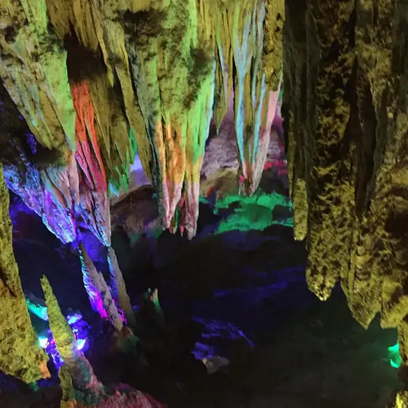 Meishan Longgong Cave · 梅山龙宫
Meishan Longgong Cave梅山龙宫
Meishan Longgong (梅山龙宫) is a multi-level karst cave system at Gaoqiao village in Youxi township, Xinhua county, Loudi, Hunan, in the heart of the Xuefeng mountains. It is a national key scenic and historic area and a national AAAA tourist area.
Read the place guide → Snow-dusted rice terraces and a hillside village at Ziquejie, Xinhua County, Hunan · 湖南新化紫鹊界梯田雪景 Source-recorded photograph date: 2016-01-23 18:03:10.
Ziquejie Rice Terraces紫鹊界梯田
Ziquejie’s rice terraces follow steep slopes around Shuiche, with water moving through a long-established gravity-fed irrigation landscape. The fields are working farmland, so their appearance changes between flooded planting…
Read the place guide →Plan your visit
Getting there
Xinhua County is about 70 km in a straight line from central Loudi. Search for 新化县 in a map app to find stations and your accommodation.
Where to stay →Build your route
Meishan Longgong Cave and Ziquejie Rice Terraces are both listed here. The linked place guides have entrance and visit details.
Continue with Loudi →More in Loudi
Sources & geographic information
Administrative names and parent areas: Official geographic directory · Reference date 2026-09-06.
Some facts checked against 紫鹊界梯田 — Wikipedia contributors, CC BY-SA 4.0.
Some facts checked against 新化县 — Wikipedia contributors, CC BY-SA 4.0.
Photo: Meishan Longgong Cave · Source photographer · License not provided. EXIF orientation normalized; resized without changing aspect ratio; converted to WebP. No subject edits.
Photo: Ziquejie Rice Terraces · Huangdan2060 · CC BY 3.0. Full frame retained; proportionally resized and converted to WebP. No retouching or changes to the photographed subject. Card displays may crop the view.

Map data © OpenStreetMap contributors. Pins mark approximate centres, not entrances or boundaries.