


Get to know Binhu District
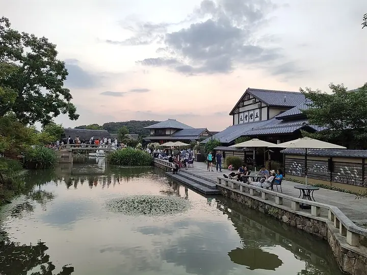
Photo adjustments
Full frame retained; proportionally resized and converted to WebP. No retouching or changes to the photographed subject. Card displays may crop the view.
- Administrative area
- District · 市辖区
- Part of
- Wuxi
- Chinese name
- 滨湖区
- Local areas
- District guide
Area & population
- Area in the source
- 608.58 km²
Source: cited geographic source, as of the dates shown.
Setting and landscape
More than half of Binhu's area is water, most of it the surface of Lake Tai, and the district's lakeshore runs for 108 kilometres. Besides Lake Tai itself, its waters take in Li Lake (蠡湖) and Meiliang Lake (梅梁湖). Low hills of Devonian quartz sandstone and siltstone ring the lake in two chains: one runs through Hui Hill (惠山), whose Sanmao Peak (三茅峰) is the district's highest point at 328 metres, and the other ends at Junzhang Hill (军嶂山) and Xuelang Hill (雪浪山). The eastern part of the district is the low, flat alluvial plain of Lake Tai, and some 250 rivers and channels cross the district.
The Changguangxi Wetland (长广溪湿地), a ten-kilometre corridor linking Li Lake with Lake Tai, was named a national urban wetland park in 2005. The Mashan (马山) subdistrict is almost cut off from the rest of the district by Wujin (武进) in Changzhou and is tied to Wuxi by land only through the Guwo Bridge (顾我桥).
History
The area was organised as Wuxi's suburban district (郊区) in 1950 and, after several changes, again from 1965; Mashan became a separate district in 1988. In December 2000 the two were merged into Binhu, which the district government dates to early 2001. Wuxi's municipal Communist Party committee and city government moved from Chong'an (崇安) to the Citizen Centre in Binhu on 15 November 2010.
What to see
The district government lists three national 5A scenic areas: the Lingshan Great Buddha scenic area (灵山胜境), the Three Kingdoms and Water Margin film city (三国水浒城), and Yuantouzhu (鼋头渚) on the lake. Its 4A areas include Mei Garden (梅园), Li Garden (蠡园), the Wuxi Zoo and the Helü City Ruins Museum (阖闾城遗址博物馆). Newer attractions named by the district include the Nianhua Bay (拈花湾) town development.
Food and local products
Chinese Wikipedia names Lake Tai whitebait (太湖银鱼), white fish (白鱼) and white shrimp (白虾) as Binhu's specialities.
Highlights
- Yuantouzhu 鼋头渚: One of the district's three national 5A scenic areas, on Lake Tai.
- Lingshan Great Buddha Scenic Area 灵山胜境: National 5A scenic area in the district.
- Three Kingdoms and Water Margin film city 三国水浒城: CCTV's Wuxi film and television base, made up of a Three Kingdoms city and a Water Margin city; rated 5A.
- Li Garden 蠡园: National 4A scenic area in the district.
- Changguangxi Wetland 长广溪湿地: Ten-kilometre wetland corridor between Li Lake and Lake Tai, a national urban wetland park since 2005.
Sources for this guide
地区概况-无锡市滨湖区人民政府 · Binhu District People's Government, Wuxi
滨湖区 - 维基百科,自由的百科全书 · Chinese Wikipedia · CC BY-SA 4.0
Original English written from the listed sources and checked sentence by sentence against quoted extracts by a separate reviewer. Updated 2026-09-25.
Explore Binhu District
Core places to explore, with English and Chinese names.
Places to explore around Binhu District
 Wuxi Three Kingdoms and Water Margin Film Studios (无锡三国水浒影视基地), Binhu District. Photograph: "三國城 - panoramio".
Wuxi Three Kingdoms and Water Margin Film Studios无锡三国水浒影视基地
The Three Kingdoms and Water Margin film studios stand by Lake Tai in Wuxi's Binhu District, offering large-scale sets associated with two classic television adaptations.
Read the place guide →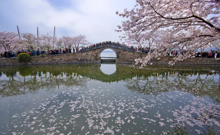 Changchun Bridge at Yuantouzhu framed by blooming cherry blossoms, Wuxi · 无锡鼋头渚长春桥樱花 Source-recorded photograph date: 2009-03-28、2014-03-28.
Yuantouzhu鼋头渚
Yuantouzhu is a peninsula on Lake Tai near Wuxi, named for its turtle-head shape. The shore paths and Changchun Bridge provide views across the water and through the park’s planted landscape.
Read the place guide →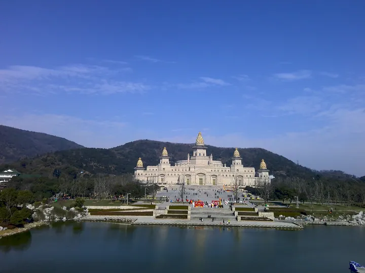 The Brahma Palace at Lingshan Scenic Area, Binhu District, Wuxi, seen across the lake with hills behind · 无锡市滨湖区灵山胜境梵宫,湖景与山峦背景 Source-recorded photograph date: 2016-02-10 10:52:54.
Lingshan Grand Buddha Scenic Area灵山胜境
Lingshan at Mashan in Wuxi is a modern Buddhist cultural landscape organised around a monumental bronze Buddha and richly decorated halls.
Read the place guide → Blossoming trees along the lakeside path in Liyuan Garden, Binhu District, Wuxi · 无锡市滨湖区蠡园湖畔花径 Source-recorded photograph date: 2017-04-02 08:56:25.
Liyuan Garden蠡园
Wuxi garden on Li Lake, named after Fan Li, built by the Wang family from 1927, with the Four Seasons Pavilions and a 289 m lakeside corridor.
Read the place guide →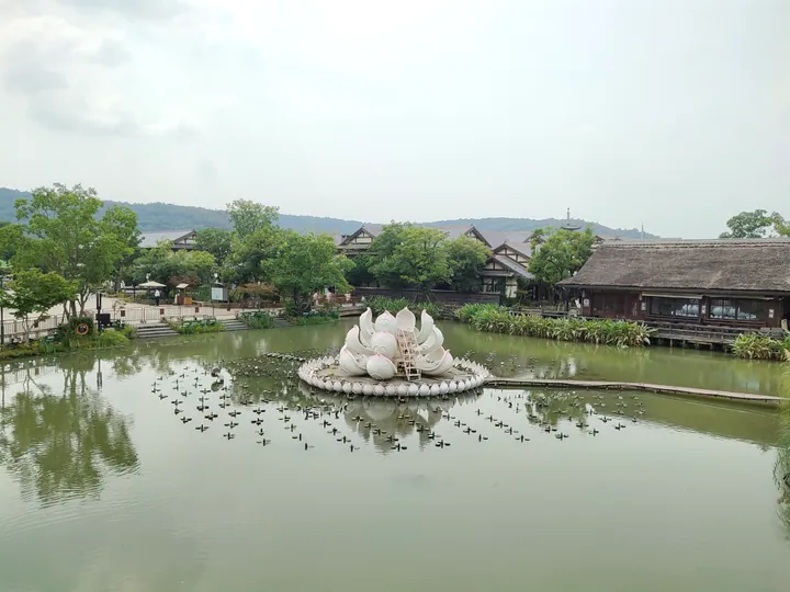 Traditional buildings and a lotus-shaped installation on the lake at Nianhua Bay, Binhu District, Wuxi · 无锡市滨湖区拈花湾,湖面莲花装置与传统建筑 Source-recorded photograph date: 2020-09-13 10:55:39.
Nianhua Bay拈花湾
Nianhuawan is a purpose-built holiday town in Wuxi whose design combines Tang and Song architectural references with a Zen-inspired Jiangnan landscape.
Read the place guide →Plan your visit
Getting there
Binhu District is about 20 km in a straight line from central Wuxi. Search for 滨湖区 in a map app to find stations and your accommodation.
Where to stay →Build your route
Wuxi Three Kingdoms and Water Margin Film Studios and Yuantouzhu are both listed here. The linked place guides have entrance and visit details.
Continue with Wuxi →More in Wuxi
Sources & geographic information
Administrative names and parent areas: Official geographic directory · Reference date 2026-09-06.
Some facts checked against 滨湖区 — Wikipedia contributors, CC BY-SA 4.0.
Photo: Wuxi Three Kingdoms and Water Margin Film Studios · ping lin · CC BY-SA 3.0. Full frame retained; EXIF orientation normalized, proportionally resized to at most 800 pixels and converted to WebP. No generated pixels or subject changes. Cards may crop the display.

Photo: Yuantouzhu · 2009/Synyan;2014/藍風攝影 · CC BY-SA 3.0. Full frame retained; proportionally resized and converted to WebP. No retouching or changes to the photographed subject. Card displays may crop the view.

Photo: Lingshan Grand Buddha Scenic Area · 西安兵马俑 · CC BY-SA 4.0. Full frame retained; proportionally resized and converted to WebP. No retouching or changes to the photographed subject. Card displays may crop the view.

Photo: Liyuan Garden · Huanokinhejo · CC BY-SA 4.0. Full frame retained; proportionally resized and converted to WebP. No retouching or changes to the photographed subject. Card displays may crop the view.

Photo: Nianhua Bay · 西安兵马俑 · CC BY-SA 4.0. Full frame retained; proportionally resized and converted to WebP. No retouching or changes to the photographed subject. Card displays may crop the view.

Map data © OpenStreetMap contributors. Pins mark approximate centres, not entrances or boundaries.