


Get to know Jiangyin
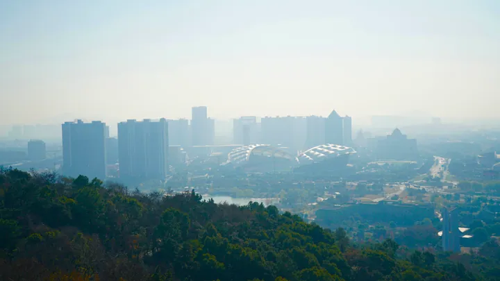
Photo adjustments
Full frame retained; proportionally resized and converted to WebP. No retouching or changes to the photographed subject. Card displays may crop the view.
- Administrative area
- County-level city · 县级市
- Part of
- Wuxi
- Chinese name
- 江阴市
- Local areas
- County-level city guide
Area & population
- Area in the source
- 987.53 km²
- Population · 2010 census
- 1,595,138
Source: cited geographic source, as of the dates shown.
History
Known in antiquity as Jiyang (暨阳), the area became Jiyang County in 281 under the Western Jin. In 555, under the Liang, the county was replaced by a commandery seated at the foot of Mount Jun (君山), and because it lay south of the Yangtze it was named Jiangyin, the first use of the name. County status returned in 1367; Jiangyin came under Wuxi in 1983 and became a city in 1987.
In the upheaval at the end of the Ming, Jiangyin rose against the Qing order to shave heads and change dress, an episode remembered as the Eighty-One Days of Jiangyin (江阴八十一日). Most of the city speaks a Wu dialect of the Piling (毗陵) group, while some riverside towns use Jianghuai Mandarin.
What to see
The Former Residence of Xu Xiake (徐霞客故居) and the stone inscriptions of the Qingshan Hall (晴山堂石刻) became a national protected site in 2001. Provincial protected sites include the ruins of the Huangshan forts (黄山炮台遗址), the Jiangyin Confucian Temple (江阴文庙), the Xingguo Temple Pagoda (兴国寺塔), the former headquarters of the Nationalist Jiangyin Fortress (国民党江阴要塞司令部旧址) and the Former Residence of the Liu Brothers (刘氏兄弟故居). City parks include Ebizui Park (鹅鼻嘴公园) and Huangshan Lake Park (黄山湖公园), and Mount Jun and Mount Huang (黄山) are among the other sights.
Getting oriented
The city government places Jiangyin at the geometric centre of the Suzhou–Wuxi–Changzhou "golden triangle" and describes it as a long-standing transport hub between the two banks of the Yangtze and a natural port for transfers between river and sea. The Jiangyin Yangtze River Bridge (江阴长江大桥) crosses to the north bank. The Beijing–Shanghai high-speed railway runs through four of its towns without stopping.
Food and local products
Local specialities include the Yangtze's "three delicacies" (长江三鲜), puffer fish (河豚), Reeves shad (鲥鱼) and the tapertail anchovy (刀鱼), which also goes into anchovy wontons and anchovy noodles. Other named foods include horseshoe pastry (马蹄酥), Shengang tofu sheets (申港百叶), Yunting pig's head meat (云亭猪头肉), Qingyang clear-broth mutton (青阳清水羊肉) and Huashi soy sauce (华士酱油).
Highlights
- Former Residence of Xu Xiake 徐霞客故居: National protected site since 2001, with the Qingshan Hall inscriptions.
- Xingguo Temple Pagoda 兴国寺塔: Provincial protected site, listed in 1995.
- Huangshan forts 黄山炮台遗址: Provincial protected site since 1982.
- Ebizui Park 鹅鼻嘴公园: City park named among Jiangyin's sights.
- Tapertail anchovy 刀鱼: Yangtze fish eaten on its own and in wontons and noodles.
Sources for this guide
建置沿革 · Jiangyin Municipal People's Government
地理位置 · Jiangyin Municipal People's Government
江阴市 - 维基百科 · Wikipedia (Chinese) · CC BY-SA 4.0
Original English written from the listed sources and checked sentence by sentence against quoted extracts by a separate reviewer. Updated 2026-09-25.
Explore Jiangyin
Core places to explore, with English and Chinese names.
Places to explore around Jiangyin
 Jiangyin Huangshan Lake and Ebizui Headland (
Plan your visit
Getting there
Jiangyin is about 40 km in a straight line from central Wuxi. Search for 江阴市 in a map app to find stations and your accommodation.
Where to stay →Build your route
Start with Jiangyin Huangshan Lake and Ebizui Headland. The linked place guides have entrance and visit details.
Continue with Wuxi →More in Wuxi
Sources & geographic information
Administrative names and parent areas: Official geographic directory · Reference date 2026-09-06.
Some facts checked against 江阴市 — Wikipedia contributors, CC BY-SA 4.0.
Photo: Jiangyin Huangshan Lake and Ebizui Headland · Yawn823 at English Wikipedia · Public domain. Full frame retained; EXIF orientation normalized, proportionally resized to at most 800 pixels and converted to WebP. No generated pixels or subject changes. Cards may crop the display.

Map data © OpenStreetMap contributors. Pins mark approximate centres, not entrances or boundaries.