


Get to know Yixing
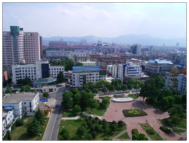
Photo adjustments
Full frame retained; proportionally resized and converted to WebP. No retouching or changes to the photographed subject. Card displays may crop the view.
- Administrative area
- County-level city · 县级市
- Part of
- Wuxi
- Chinese name
- 宜兴市
- Local areas
- County-level city guide
Area & population
- Area in the source
- 1,996.60 km²
- Population · 2020
- 1,075,800
- Administrative seat
- Yicheng Subdistrict
Source: cited geographic source, as of the dates shown.
Setting and landscape
Yixing has no land border with the rest of Wuxi: the two are linked by the Zhushan Lake Tunnel (竺山湖隧道) under Lake Tai. The land rises from north to south. The south is low hills, topped by Huangtading (黄塔顶) at 611.5 metres, and many of the hills hold karst caves, among them Shanjuan Cave (善卷洞), Linggu Cave (灵谷洞) and Zhanggong Cave (张公洞). The north is plain and the west low-lying polder land. The Jingxi River (荆溪) and the Xijiu (西氿), Tuanjiu (团氿) and Dongjiu (东氿) lakes form a chain across the city's territory from west to east. The southern hills carry large stands of moso bamboo split into three bamboo forests at Hufu (湖滏), Mingling (茗岭) and Taihua (太华).
History
The Qin created Yangxian County (阳羡县) here in 221 BC. The area was later called Yixing (义兴), and in 976 the name was changed to the present Yixing (宜兴) to avoid the personal name of Emperor Taizong of Song. The city became county-level in January 1988, and the State Council named it a national historic and cultural city in 2011. The Yixing county gazetteer places the origin of the Butterfly Lovers legend (梁祝传说) in Yixing, and the Guoshan Stele (国山碑), a Three Kingdoms relic on Guoshan in the south-west, is a national key heritage site.
What to see
Chinese Wikipedia lists eight national 4A scenic areas, including Shanjuan Cave, Zhanggong Cave, the bamboo forest, the Tuanjiu lake area and the China Yixing Ceramics Museum (中国宜兴陶瓷博物馆). Other historic sites include the temple to Zhou Chu (周处), a Taiping Heavenly Kingdom prince's mansion and the Dongpo Academy (东坡书院) in Dingshu (丁蜀), where a shrine to Su Shi (苏轼) was rebuilt in 1501 and given the academy's name; the site is now a provincial heritage site.
Food and local products
Zisha pottery making at Dingshu is on the national intangible heritage list, entered in 2006. According to the national heritage register, the craft arose in the Song and Yuan and matured in the Ming, using a purple clay particular to Yixing and more than a hundred home-made tools; the pieces are usually left unglazed, and teapots are its best-known products. Yixing also makes celadon, jun-type and painted wares. Yangxian tea (阳羡茶) was sent as tribute from the Tang onwards. Local products include Jingxi snow celery (荆溪雪芹), a white-stemmed celery eaten stir-fried or cold, Heqiao dried tofu (和桥豆腐干) and Yixing lilies (宜兴百合).
Highlights
- Zisha pottery making 宜兴紫砂陶制作技艺: National intangible heritage since 2006, centred on Dingshu; mostly unglazed teapots of local purple clay.
- Shanjuan Cave 善卷洞: Karst cave in the southern hills; a national 4A scenic area.
- China Yixing Ceramics Museum 中国宜兴陶瓷博物馆: Also known as the China Zisha Museum; a national 4A scenic area.
- Yixing bamboo forest 宜兴竹海: Moso bamboo in three areas at Hufu, Mingling and Taihua.
- Dongpo Academy 东坡书院: Su Shi shrine in Dingshu, rebuilt and named Dongpo Academy in 1501; provincial heritage site.
Sources for this guide
宜兴市 - 维基百科,自由的百科全书 · Chinese Wikipedia · CC BY-SA 4.0
宜兴紫砂陶制作技艺 - 中国非物质文化遗产网·中国非物质文化遗产数字博物馆 - 中国非物质文化遗产网非遗 · China Intangible Cultural Heritage Network (ihchina.cn)
Original English written from the listed sources and checked sentence by sentence against quoted extracts by a separate reviewer. Updated 2026-09-25.
Explore Yixing
Core places to explore, with English and Chinese names.
Places to explore around Yixing
 Yixing Ceramics Museum and Dingshu Gunan Street · 陶瓷博物馆与丁蜀古南街
Yixing Ceramics Museum and Dingshu Gunan Street陶瓷博物馆与丁蜀古南街
China Yixing Ceramics Museum and Shushan Gunan Street reveal two sides of Dingshu's pottery tradition: collected objects and the old streets of purple-clay production and trade.
Read the place guide → A waterfall dropping in white veils down a mossy limestone cliff into a pool at the bottom of a gorge, a timber pavilion with a balustraded gallery perched on the clifftop above it, dense green foliage overhanging at the left and right, and stone steps curving down at the lower right.
Shanjuan Cave善卷洞
Karst cave in Zhangzhu, Yixing, in four parts, with a 120 m underground boat ride, a Butterfly Lovers link and the Guoshan Stele of 276.
Read the place guide → A pavilion among the dense bamboo groves of Yixing Bamboo Sea scenic area, Yixing · 宜兴竹海风景区茂密竹林中的阁楼 Source-recorded photograph date: Taken on 6 September 2008.
Yixing Bamboo Sea宜兴竹海
Yixing Bamboo Sea occupies low hills in Hufu Town, where extensive moso bamboo woodland is interspersed with springs, streams and freshwater scenery.
Read the place guide →Plan your visit
Getting there
Yixing is about 30 km in a straight line from central Wuxi. Search for 宜兴市 in a map app to find stations and your accommodation.
Where to stay →Build your route
Yixing Ceramics Museum and Dingshu Gunan Street and Shanjuan Cave are both listed here. The linked place guides have entrance and visit details.
Continue with Wuxi →More in Wuxi
Sources & geographic information
Administrative names and parent areas: Official geographic directory · Reference date 2026-09-06.
Some facts checked against 宜兴市 — Wikipedia contributors, CC BY-SA 4.0.
Photo: Yixing Ceramics Museum and Dingshu Gunan Street · Source photographer · License not provided. EXIF orientation normalized; resized without changing aspect ratio; converted to WebP. No subject edits.
Photo: Shanjuan Cave · No machine-readable author provided. Whw assumed (based on copyright claims). · Public domain. Full frame retained; proportionally resized and converted to WebP. No retouching or changes to the photographed subject. Card displays may crop the view.

Photo: Yixing Bamboo Sea · 山海风 · CC BY-SA 3.0. Full frame retained; proportionally resized and converted to WebP. No retouching or changes to the photographed subject. Card displays may crop the view.

Map data © OpenStreetMap contributors. Pins mark approximate centres, not entrances or boundaries.