

Explore the region
A gateway town with its own scale
Erdaobaihe lies in Antu County at the foot of Changbai Mountain and is administered within the Changbai Mountain Protection and Development Zone’s Chibei area. Government descriptions identify it as an important service base and northern gateway for the mountain, while also presenting the town as a place where residents and visitors share a river-led slow-movement landscape. The town and the North Scenic Area are separate plans: staying in Erdaobaihe does not by itself include mountain admission, the mountain shuttle, or a view of Tianchi. The official regional guide places the North Scenic Area in Chibei and distinguishes it from the West and South areas.
That distinction is useful for planning. Give the town a half-day or an evening of its own rather than treating every green space as part of the mountain ticket. The most characteristic rhythm is low and unhurried: follow the river corridor, look up into the straight crowns of the Meirensong pines, then climb for a broader view before returning to the built-up streets.
What to look at
The town’s identity comes from the meeting of water, tall pines and designed public space. The national development case study describes a slow-movement landscape organised around the Erdaobaihe River, with walking and cycling routes intended for both everyday residents and visitors. A local feature in People’s Daily’s Jilin edition also describes the town’s Meirensong Sculpture Park, its forest setting and a collection of outdoor sculptures. Treat the sculptures as part of a woodland walk: the contrast between worked forms and the red-pine trunks is more distinctive than rushing from one object to the next.
The Meirensong aerial-walkway park gives the same landscape a different scale. The project’s own description places it on relatively high ground in Erdaobaihe, facing a broad stand of Meirensong pines and water where streams gather. Its pedestrian bridge and viewing elements were designed for both local slow movement and visitor outlooks, and the project was completed in 2017. Walk the ground-level park first, then use the raised route if it is open and safe on the day; the point is to compare the river-and-pine setting from below and above, not to assume that every platform or service building is always accessible.
Wetland and riverside spaces extend the same idea beyond the two signature parks. Local coverage highlights boardwalk landscapes and the Chianshui River National Wetland Park as places to notice open water, low vegetation and seasonal planting. Conditions, flowers and bird activity change with the season, so observe what is present rather than travelling for a guaranteed display. Keep to marked paths and do not enter unmanaged river or wetland edges.
A simple way to visit
For a first look, begin with a riverside or wetland walk in daylight. Continue to the Meirensong Sculpture Park, allowing time to look at the trees as well as the artworks, and then cross to the aerial-walkway park for the higher perspective. This is an editorial sequence, not a claim of a shared entrance, common ticket or fixed walking time. Use the exact Chinese park name in Amap or Apple Maps because “Erdaobaihe” covers a wider settlement than any one park entrance.
If you are using a bicycle, confirm that a current rental or public-bike service is operating before relying on it; the town’s slow-movement planning and earlier public-bike provision do not guarantee a particular outlet today. In the evening, return to the town streets and river edge rather than assuming that a mountain excursion has finished at a town attraction.
Keep a North Scenic Area day separate
For Changbai Mountain’s North Scenic Area, use the North Scenic Area Visitor Distribution Centre (长白山北景区游客集散中心), not a generic town pin. The published notice places it at the southern end of Erdaobaihe Avenue, in Changbaishan Legend Town, east of the Changbaishan Natural Museum; it states that the North Scenic Area gate function was moved down to the centre, with the old gate retaining only limited checking functions. Later official reporting still describes timed reservation, capacity controls and check-in at the North distribution centre.
The centre is therefore the practical starting point for a mountain day, but it is not the entrance to the town’s sculpture park or aerial walkway. Check the official Changbai Mountain booking channel before leaving your accommodation. A 2024 official notice says that the “长白山一机游” mini-program and the official “长白山” channel show booking information and synchronised online and on-site inventory; it also warns that an on-site centre cannot sell a ticket when online inventory is gone. The public notices read for this article do not state how every passport-holder booking or identity check is handled, so visitors using a passport should confirm that point with the official channel before depending on a reservation.
Getting there and getting back
For rail travel, search for Changbaishan Station (长白山站). A 2026 report from the Changbai Mountain administration identifies the station and describes Chibei routes 1, 2 and 3, together with the T010 intercity scenic loop, as links between the high-speed station, the North Scenic Area distribution centre and town attractions. Stop patterns and operating arrangements can change, so verify the route, direction and final stop on your travel date.
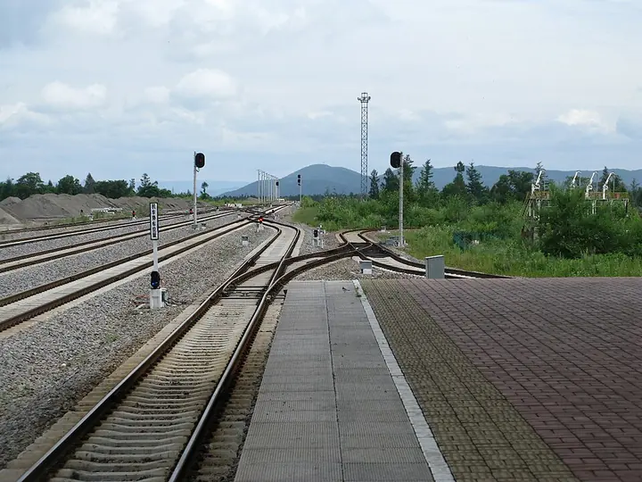
At the station, give the driver the exact Chinese destination. For a town outing, say the name of the particular park; for the mountain, say “长白山北景区游客集散中心,池北区二道白河大街南端,长白山传奇小镇,长白山自然博物馆东侧.” This avoids turning the town name into a supposed single entrance. For the return, book the next train from 长白山站 or a coach from 二道白河客运站 before committing to a late mountain transfer. The older official transport guide calls the local railway stop “白河站” and places the coach station opposite it, but that 2021 page predates the current high-speed-era naming and should be treated as historical transport guidance rather than a live timetable.
If you arrive by air, a 2025 official report described a Changbaishan Airport–Chibei on-demand service arranged through the “智行旅游交通出行” WeChat mini-program or 0433-5310466. The report does not establish year-round operation, so confirm availability before relying on it.
There is no need to invent a fixed fare, travel time or one universal town entrance. Recheck the park’s current access, the mountain reservation, the final local stop and the return connection separately.
Combine your visit
Suggested order within this visit:
-
Meirensong International Sculpture Park
Begin with the outdoor artwork and planted landscape.
-
Meirensong aerial-walkway park
Compare the ground-level park with a raised view, subject to platform access.
This sequence is an editorial suggestion based on the features described in the sources. Access to individual buildings or areas should be checked locally; no travel time or shared admission is implied.
Find Erdaobaihe Town
二道白河 · 安图县
The pin marks the area, not the entrance.
More places nearby
Approximate straight-line distances between map pins, not travel distances.
Changbai Waterfall 长白山瀑布
46 km awayChangbai Waterfall descends from the northern outlet of Tianchi through the mountain's volcanic landscape. Its narrow upper stream opens into a dramatic fall above the valley, while the Julong hot-spring area below adds evidence…
View guide →Changbai Mountain Tianchi 长白山天池
49 km awayChangbai Mountain Tianchi fills a volcanic crater on the China–North Korea border, framed by steep, sparsely vegetated peaks. The contrast between the enclosed blue water and the broken volcanic rim is the main visual…
View guide →Changbai Mountain West Slope 长白山西坡
52 km awayChangbai Mountain's western route offers a broad view into Tianchi together with forest and volcanic landforms lower down. The ascent from the upper transport stop involves a substantial staircase, making mobility an important…
View guide →Sources & visit information
Sources checked on 1 November 2026. Hours, tickets, reservations and transport can change; confirm with the operator before you go.
Image credits & notes (1)
- Baihe railway station in Erdaobaihe, photographed in 2012 · 二道白河白河站 Photograph date recorded by the source: 3 August 2012, 11:24.Photo: Caitriana Nicholson from 北京 ~ Beijing, 中国 ~ China · CC BY-SA 2.0Resized for the web; the photo itself has not been edited. Thumbnails may show a cropped view.
