


Get to know Nanfen District
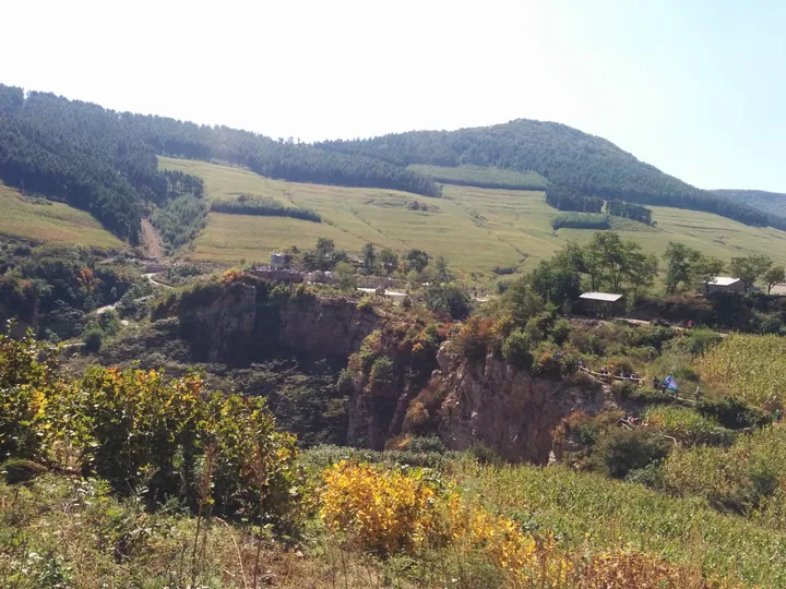
Photo adjustments
Full frame retained; proportionally resized and converted to WebP. No retouching or changes to the photographed subject. Card displays may crop the view.
- Administrative area
- District · 市辖区
- Part of
- Benxi
- Chinese name
- 南芬区
- Local areas
- District guide
Area & population
- Area in the source
- 615.40 km²
- Population · 2020 census
- 55,560
Source: cited geographic source, as of the dates shown.
Setting and landscape
Low and middle-height mountains, hills and the valleys between them make up most of the district, with small alluvial plains along the Xi River, which runs 29 of its 120 kilometres through Nanfen. Forest covers 78.89 per cent of the land. Cold spring water around Yangmugou (杨木沟), Taipingshan (太平山) and Huangboyu (黄柏峪) suits rainbow trout, the district is a known trout-producing base in Liaoning, and Nanfen rainbow trout (南芬虹鳟鱼) is a national geographical-indication product. The district government describes the Benxi Steel open-pit iron mine (本钢露天铁矿) here as the largest open-pit iron mine in Asia.
History
The name was once written with the character for "grave" (南坟, "southern grave"): Chinese Wikipedia says a Kangxi-era governor moved his family tombs here, south of Benxi Lake, and the character was changed in 1942. A Nanfen district was set up in 1948, became a town in 1958 and was restored as a district in 1984.
Japan built the Andong–Mukden railway (安奉铁路) in 1905, and in 1931 Japanese troops lined it with pillboxes; three survive in the Nanfen section. The one at Baiyu (柏峪碉堡), on the bank of the Xi River, is a two-storey reinforced-concrete drum about 5 metres high with 12 embrasures on top. In 1934 an anti-Japanese volunteer band of more than 70 men under Wang Dianjia (王殿甲) used Dabinggou as its base against the railway.
What to see
Dabinggou (大冰沟), a national AAAA scenic area, is known for ice that lasts into June. The Benxi Grand Canyon (本溪大峡谷), a AAA scenic area, has what the district calls the longest glass walkway in northeast China. Nantianmen (南天门), in Baiyu village, is a large gap in the summit rocks shaped like a city gate on the old mountain road from Benxi to Dandong; it was a location for the film "Heroic Sons and Daughters" (英雄儿女). The broken arch railway bridge at Zhangjiabao (张家堡铁路断桥), over the Xi River at Xiamatang (下马塘), was used by the August First Film Studio as an outdoor location in the late 1990s.
Local products
Nanfen is the home of Liao inkstones (辽砚), a national geographical-indication product cut from the local Qingyun (青云石) and Ziyun (紫云石) stones and counted among the "four treasures of Liaoning".
Getting oriented
The Shenyang–Dandong Railway (沈丹铁路), the Shenyang–Dandong high-speed line (沈丹客专), the Dandong–Fuxin Expressway (丹阜高速公路) and National Highway 304 run the length of the district, which has four railway stations.
Highlights
- Dabinggou 大冰沟: AAAA scenic area where ice lasts into June; a 1934 anti-Japanese base.
- Nantianmen 南天门: Gate-shaped gap in the rock on the old Benxi–Dandong road; a film location.
- Baiyu pillbox 柏峪碉堡: Japanese two-storey concrete pillbox of 1931 beside the Xi River.
- Zhangjiabao broken railway bridge 张家堡铁路断桥: Arch railway bridge over the Xi River used as a film set.
- Liao inkstone 辽砚: GI-protected inkstone cut from local Qingyun and Ziyun stones.
- Nanfen rainbow trout 南芬虹鳟鱼: GI-protected trout raised in cold spring water.
Sources for this guide
南芬概况_南芬概况_南芬区人民政府门户网站 · Nanfen District People's Government, Benxi
自然资源_南芬概况_南芬区人民政府门户网站 · Nanfen District People's Government, Benxi
特色产业_南芬概况_南芬区人民政府门户网站 · Nanfen District People's Government, Benxi
历史名人和名胜古迹_南芬概况_南芬区人民政府门户网站 · Nanfen District People's Government, Benxi
南芬区 - 维基百科,自由的百科全书 · Wikipedia (Chinese) · CC BY-SA 4.0
Original English written from the listed sources and checked sentence by sentence against quoted extracts by a separate reviewer. Updated 2026-09-25.
Explore Nanfen District
Core places to explore, with English and Chinese names.
Nanfen District 南芬区
Plan your visit
Getting there
Nanfen District is about 25 km in a straight line from central Benxi. Search for 南芬区 in a map app to find stations and your accommodation.
Where to stay →More in Benxi
Sources & geographic information
Administrative names and parent areas: Official geographic directory · Reference date 2026-09-06.
Some facts checked against 南芬区 — Wikipedia contributors, CC BY-SA 4.0.
Map data © OpenStreetMap contributors. Pins mark approximate centres, not entrances or boundaries.