


Get to know Dawa District
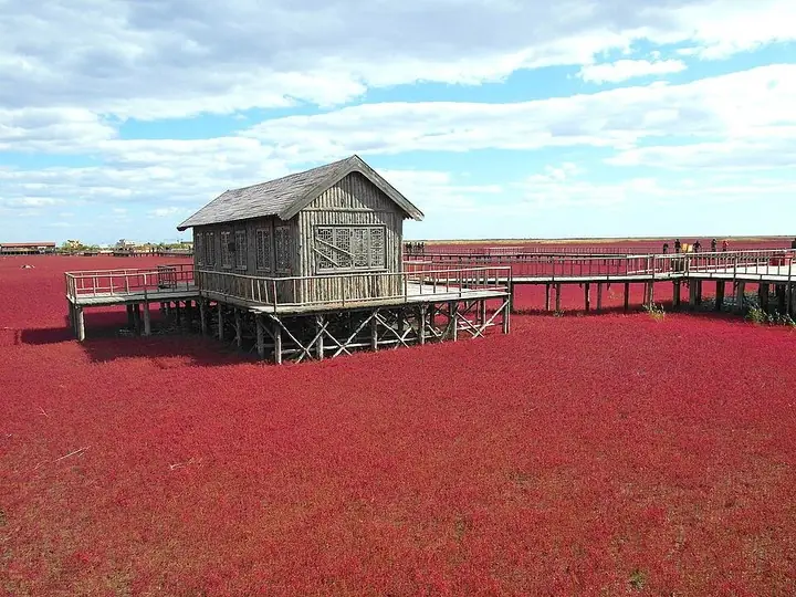
Photo adjustments
The exact downloaded source bytes are separately retained and hashed. Prepared JPEG is proportionally reduced to a maximum 720-pixel long edge; full frame retained, no subject alteration. Final website rendition: full frame retained, proportionally resized to at most 720 pixels and converted to WebP. No additional retouching or subject alteration. Card displays may crop the view.
- Administrative area
- District · 市辖区
- Part of
- Panjin
- Chinese name
- 大洼区
- Local areas
- District guide
Area & population
- Area in the source
- 1,683.00 km²
- Population · 2020 census
- 422,797
Source: cited geographic source, as of the dates shown.
Setting and landscape
The district government describes Dawa as one of the world's most complete wetland ecosystems, shared with more than 260 rare bird species including the red-crowned crane (丹顶鹤) and Saunders's gull (黑嘴鸥). Oil and gas reserves are large: Dawa is a main production area of the Liaohe Oilfield (辽河油田), and it also has underground hot-spring water. Its Panjin rice and Panjin river crab are known far beyond the district.
History
In the Qing dynasty the area belonged to Haicheng County (海城县). Dawa became a county under Yingkou (营口) on 9 November 1975, passed to the new city of Panjin in 1984, was named a coastal open county in 1988, and became a district of Panjin in 2016. The Tianzhuangtai site of the First Sino-Japanese War (甲午战争田庄台遗址) is listed as a national key protected site.
What to see
The Red Beach National Scenic Corridor (红海滩国家风景廊道) runs along the coastal highway in Zhaoquanhe town (赵圈河镇). The Ministry of Agriculture and Rural Affairs notes that the beach turns a light red in early April, deepens through the summer and shifts from red to purple in October, and gives May to October as the best months. Close by, at Jieguanting (接官厅) in the Liao River delta, the Red Beach Wetland Science Museum (红海滩湿地科学馆) presents Red Beach through the four seasons. Zhaoquanhe was chosen in the first national batch of characteristic towns.
At Erjiegou (二界沟) on the Liao River estuary lived the 'Guyuyan' (古渔雁, 'ancient fishing geese'): fishermen from central and eastern Hebei who, lacking boats for deep-sea fishing, migrated like birds along the shore to fish the mudflats. Their folk tales were placed on the first national intangible-heritage list in 2006; local cultural authorities have recorded close to a thousand stories and more than a thousand fishing songs. At the Erjiegou Guyuyan Culture Village (二界沟古渔雁文化村) visitors can pick river crabs and try sieving small shrimp. The district government also lists the Heifengguan old town (黑风关古镇) and the Zhiqing headquarters (知青总部) among its 3A-or-higher scenic areas.
Highlights
- Red Beach National Scenic Corridor 红海滩国家风景廊道: Coastal wetland in Zhaoquanhe town that turns red from April and purple in October.
- Red Beach Wetland Science Museum 红海滩湿地科学馆: Wetland museum at Jieguanting in the Liao River delta.
- Guyuyan folk tales 古渔雁民间故事: Stories of migrant estuary fishermen at Erjiegou; national intangible heritage since 2006.
- Tianzhuangtai site 甲午战争田庄台遗址: Site of the First Sino-Japanese War; national key protected site.
Sources for this guide
大洼概况_大洼区人民政府 · Dawa District People's Government
大洼区 - 维基百科,自由的百科全书 · Chinese Wikipedia · CC BY-SA 4.0
古渔雁民间故事 - 中国非物质文化遗产网·中国非物质文化遗产数字博物馆 · China Intangible Cultural Heritage Network
辽宁省盘锦市大洼区 盘锦生态休闲之旅 · Ministry of Agriculture and Rural Affairs of the PRC
Original English written from the listed sources and checked sentence by sentence against quoted extracts by a separate reviewer. Updated 2026-09-26.
Explore Dawa District
Core places to explore, with English and Chinese names.
Places to explore around Dawa District
Plan your visit
Getting there
Dawa District is about 15 km in a straight line from central Panjin. Search for 大洼区 in a map app to find stations and your accommodation.
Where to stay →Build your route
Start with Red Beach (Panjin). The linked place guides have entrance and visit details.
Continue with Panjin →More in Panjin
Sources & geographic information
Administrative names and parent areas: Official geographic directory · Reference date 2026-09-06.
Some facts checked against 大洼区 — Wikipedia contributors, CC BY-SA 4.0.
Photo: Red Beach (Panjin) · 吴张帆 · 吴张帆 — 盘锦红海滩.JPG — CC BY-SA 3.0 · CC BY-SA 3.0. The exact downloaded source bytes are separately retained and hashed. Prepared JPEG is proportionally reduced to a maximum 720-pixel long edge; full frame retained, no subject alteration. Final website rendition: full frame retained, proportionally resized to at most 720 pixels and converted to WebP. No additional retouching or subject alteration. Card displays may crop the view.

Map data © OpenStreetMap contributors. Pins mark approximate centres, not entrances or boundaries.