

Photo adjustments
Full frame retained; proportionally resized and converted to WebP. No retouching or changes to the photographed subject. Card displays may crop the view.
Explore the region
About Head Mountain
The approach moves from a forest boardwalk to a long stair climb, ending at a lookout over the city, river valleys and surrounding rice fields when visibility allows. The woodland section is worthwhile even without completing the ascent. This is Yanji's Mao'er Mountain, distinct from the mountain of the same name in Heilongjiang, so use the Yanlong Road entrance when planning the visit.
In early 1991 the Yanji city government formed a Mao'ershan Development and Management Leading Group to plan the mountain's development and attract investment. The park was officially approved as a national forest park by the Ministry of Forestry in November 1992, with the city government setting a development direction centered on forest vegetation combined with Korean ethnic customs and cultural sights for tourism, sightseeing and vacationing. In 2007 Mao'ershan was incorporated into Yanji's citywide development plan with an investment of 10 million yuan, funding facilities such as a leisure plaza at the foot of the mountain, a park management office, a parking lot, and the wooden boardwalk running from the entrance to the peak.
The park covers 1,100 hectares in the southern outskirts of Yanji, with a highest elevation of 517.2 meters and a forest coverage rate of 76.1 percent. It is regarded as a natural viewing platform over the Buerhatong River (布尔哈通河) and Hailan River (海兰江), and is Yanji's only national-level forest park.
What to look for
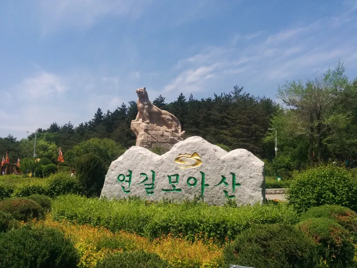
- The forest boardwalk beginning near the entrance's tiger statue.
- The summit lookout over Yanji and the surrounding river-and-rice-field landscape.
Location & getting there
Getting to Head Mountain
Use the main forest-park car park and entrance on Yanlong Road in southern Yanji. Start towards the tiger statue and boardwalk, then decide whether the extended staircase is suitable.
Combine your visit
Suggested order within this visit:
-
Tiger-statue entrance and boardwalk
Begin with the forest at a gentler level.
-
Summit lookout
Continue up the stairs only if the climb and visibility suit the group, returning by the confirmed open path.
This sequence is an editorial suggestion based on the features described in the sources. Access to individual buildings or areas should be checked locally; no travel time or shared admission is implied.
Find Head Mountain
延吉帽儿山 · 延边朝鲜族自治州
The pin marks the area, not the entrance.
More places nearby
Approximate straight-line distances between map pins, not travel distances.
Yanji Dinosaur Museum 延吉恐龙博物馆
2 km awayYanji's dinosaur museum grew from fossil discoveries made at Longshan on Mao'er Mountain's southern slope. Its six Korean-style buildings divide the visit between a broad Dinosaur Planet introduction and the Dragon Rising in…
View guide →Korean Folk Customs Park of China 中国朝鲜族民俗园
3 km awayThe Korean Folk Customs Park in southern Yanji is a purpose-built cultural landscape arranged around traditional-style homes, food and performance spaces. It presents the appearance of a village while accommodating restaurants…
View guide →Yanbian Museum 延边博物馆
6 km awayYanbian Museum connects local archaeology with the history and cultural life of ethnic Korean communities in China. The excavated-relics galleries introduce the region's earlier societies, while the folk-customs displays bring…
View guide →Sources & visit information
The sources below support the place-specific description and arrival information. Suggested combinations are editorial planning ideas; confirm current opening, entry arrangements and transport services for your date.
Visitor information adapted and edited from Wikipedia contributors · CC BY-SA 4.0. Source revision 90901402.
Visitor information adapted and edited from Wikivoyage contributors · CC BY-SA 4.0.
Background paragraphs translated and condensed from Wikipedia contributors, "延吉帽儿山国家森林公园", Chinese Wikipedia · CC BY-SA 4.0. Source revision 90901402.