


Get to know Rushan
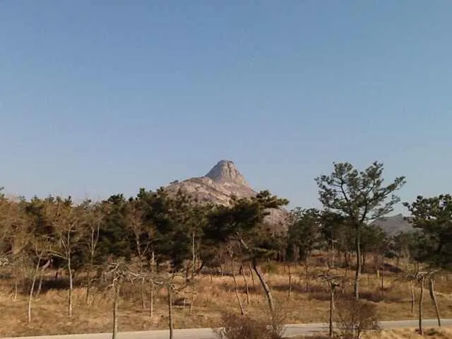
Photo adjustments
Full frame retained; proportionally resized and converted to WebP. No retouching or changes to the photographed subject. Card displays may crop the view.
- Administrative area
- County-level city · 县级市
- Part of
- Weihai
- Chinese name
- 乳山市
- Local areas
- County-level city guide
Area & population
- Area in the source
- 1,665.00 km²
- Population · 2019
- 494,000
- Administrative seat
- Xiacun Village
Source: cited geographic source, as of the dates shown.
Setting and landscape
Haiyang (海阳) lies to the west, Wendeng District (文登区) to the east and Muping District (牟平区) to the north. Hills close the city in on three sides; the highest is Duoshan (垛山), also called Fayun Mountain (发云山), at 612.6 metres. The Rushan River (乳山河), known as the Duo River (垛河) in the Republican era, rises at Duoyuding (垛鱼顶) on the southern side of Mashi Mountain (马石山), runs 65 kilometres through eight towns and enters the Yellow Sea at Rushankou Bay (乳山口湾).
The hills are rich in gold, and a silver-white beach winds for 20 kilometres along the coast, which together earn the area the name "golden hills, silver beach" (金岭银滩). The sea and the ring of low hills keep summers cool, and winters bring little snow.
History
The first county in the area, Yuli County (育犁县), was set up in 206 BC. In the diary of his travels in Tang China, kept from 838 to 848, the Japanese monk Ennin (圆仁) mentions Rushan many times, describing its steep, pointed peak and recording ships anchoring at Rushan, including envoys to Silla (新罗) who boarded ship at Rushan harbour (乳山浦).
The modern county grew out of the war against Japan. In 1941, as the anti-Japanese base area took shape, the land between Muping and Haiyang counties became a new unit, Mouhai County (牟海县), named from the first characters of both; in 1945 it was renamed Rushan County after Big Rushan. It became a county-level city under Weihai in 1993.
What to see
Scenic areas include the Silver Beach (银滩) resort and the Big Rushan resort on the coast, both rated 4A, Juyu Mountain Forest Park (岠嵎山森林公园), the Shengshui Palace (圣水宫), a Taoist site, and Mashi Mountain (马石山). Up to the Xia the area belonged to the land of Yuyi (嵎夷), named in the Book of Documents (尚书), and Juyu Mountain still carries the character yu (嵎).
The coastline runs for 185 kilometres, and its shallow waters yield more than 100 kinds of fish, shrimp and shellfish. Tussah silkworms (柞蚕) have been raised here for more than two thousand years.
Highlights
- Big Rushan 大乳山: 216.6-metre breast-shaped hill on the shore that gave the city its name; a 4A coastal resort.
- Silver Beach 银滩: Resort on the 20-kilometre silver-white beach; rated 4A.
- Rushan River 乳山河: 65-kilometre river from Mashi Mountain to Rushankou Bay.
- Shengshui Palace 圣水宫: Taoist site among the city's scenic areas.
Sources for this guide
乳山市 - 维基百科,自由的百科全书 · Wikipedia (Chinese) · CC BY-SA 4.0
乳山河 - 维基百科,自由的百科全书 · Wikipedia (Chinese) · CC BY-SA 4.0
Rushan, Shandong - Wikipedia · Wikipedia (English) · CC BY-SA 4.0
Original English written from the listed sources and checked sentence by sentence against quoted extracts by a separate reviewer. Updated 2026-09-23.
Explore Rushan
Core places to explore, with English and Chinese names.
Places to explore around Rushan
 AI illustration · AI
 Plan your visit
Getting there
Rushan is about 85 km in a straight line from central Weihai. Search for 乳山市 in a map app to find stations and your accommodation.
Where to stay →Build your route
Start with Silver Beach. The linked place guides have entrance and visit details.
Continue with Weihai →More in Weihai
Sources & geographic information
Administrative names and parent areas: Official geographic directory · Reference date 2026-09-06.
Some facts checked against 乳山市 — Wikipedia contributors, CC BY-SA 4.0.
Some facts checked against 乳山河 — Wikipedia contributors, CC BY-SA 4.0.
Some facts checked against Rushan, Shandong — Wikipedia contributors, CC BY-SA 4.0.
Map data © OpenStreetMap contributors. Pins mark approximate centres, not entrances or boundaries.