

Explore the region
Why come
Xinduqiao’s appeal is cumulative. The town government places it in western Kangding at the meeting point of G318 and G248, with the town seat at about 3,460 metres and the wider township averaging above 3,500 metres. It is a working highland town and a junction for journeys west towards Yajiang and Litang, or north towards Daofu and Dege, rather than an isolated lookout reached through one entrance.
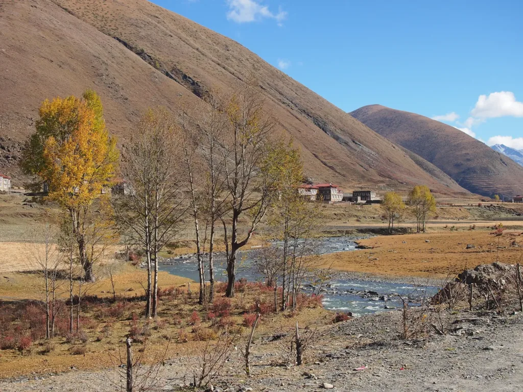
The landscape is most legible from the road and its public edges. A Ganzi government feature describes a corridor of more than 10 kilometres, with shallow streams, stands of poplar, grassland, folded mountains, scattered Tibetan villages and grazing animals. The light changes quickly as clouds cross the valley, so a short stop in more than one place is more rewarding than searching for a single “best” platform.
What to look for
Start by noticing how the junction works: traffic, roadside businesses and village roads meet here, while the valley opens and narrows as you move along the corridor. Look for the contrast between the pale trunks of the poplars, the dark water of small streams and the broad grassland beyond them. The older local description also notes Tibetan homes with broad white-walled courtyards, painted window surrounds and red doors; view them from public roads and do not enter a courtyard without an invitation.
This is a place for patient observation rather than a checklist. In clear weather, watch how the mountain slopes frame the fields; in autumn, the poplars provide the strongest colour; in cloud or changing light, the same road can feel much more enclosed. Residents, herders and passing vehicles are part of a working town, not a performance. Ask before photographing people, homes or animals, and keep to safe roadside spaces rather than standing on the highway for a view.
Planning the visit
Do not plan Xinduqiao as one walkable park. The township covers about 965 square kilometres and includes 25 administrative villages and one community. Choose a specific, currently available lodging, village stop or viewing place before setting out; “新都桥” alone is too broad for a driver or for a return plan.
No town-wide entrance ticket, reservation system or single visitor gate is identified in the sources reviewed. That does not make every nearby monastery, viewing platform, commercial project or village activity open to walk-in visitors. Treat the public road corridor separately from any named facility, and check that facility’s own current access rules before leaving the main road. The city’s tourism plan also describes an Xinduqiao photography-town project and other improvements; a planning document is not an opening notice or a current ticket schedule.
At this altitude, keep the first outing short and leave room for rest, water and changing weather. Cold, strong sun and wind can occur in the same day. If you feel unwell, stop walking and seek local help rather than continuing to a higher viewpoint. Do not follow informal tracks into unstable slopes, river edges or unmanaged mountain areas.
Getting there and back
The most clearly documented public road option is from Kangding. The Kangding government’s current transport notice lists a Kangding–Tagong rural bus service in both directions at 08:00 and 15:00 daily. Within Xinduqiao, its listed stops include 新一站, 东一站, 东二站, 下三站, 下一站, 上二站, 上一站, 拔一站 and 拔二站; the listed fares rise from 15 yuan at 新一站 to 19 yuan at 拔一站 and 拔二站, with 20 yuan shown for the full journey to 塔公.
The same notice lists a Kangding–Shade service at 07:40 and 15:00 daily and says that it passes through Xinduqiao. Because the notice is dated 20 May 2026, use it as the latest official timetable found here, not as a guarantee that a particular bus will have space or that every stop will suit your return. Confirm the departure board and the return direction locally before leaving Kangding or walking away from the road.
The town government’s published address is 康定市新都桥镇人民路33号. It is a fixed administrative landmark, not a tourist entrance. For a taxi or private car, carry the exact Chinese name and address of your lodging or intended stop; there is no single reliable drop-off point for the whole town.
Find Xinduqiao Town
新都桥 · 康定市
The pin marks the area, not the entrance.
Sources & visit information
Sources checked on 1 November 2026. Hours, tickets, reservations and transport can change; confirm with the operator before you go.
Image credits & notes (1)
- Autumn poplars and a stream beside a settlement in Xinduqiao, with dry mountain slopes behind; photographed on 26 October 2012. Photo: rheinsPhoto: CC BY 3.0