


Get to know Kangding
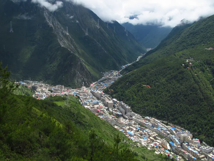
Photo adjustments
Full frame retained; proportionally resized and converted to WebP. No retouching or changes to the photographed subject. Card displays may crop the view.
- Administrative area
- County-level city · 县级市
- Part of
- Garzê Tibetan Autonomous Prefecture
- Chinese name
- 康定市
- Local areas
- County-level city guide
Area & population
- Area in the source
- 11,486.00 km²
- Population · 2020
- 126,785
- Administrative seat
- Lucheng Subdistrict
Source: cited geographic source, as of the dates shown.
Setting and landscape
Mount Zheduo (折多山) and Mount Gongga (贡嘎山) run north to south through the city. Zheduo divides it in two: high mountains and gorges to the east, and to the west hilly plateau in the north-west and deep plateau valleys. The city government gives a range of altitude from 1,390 metres to 7,556 metres, and more than 140 rivers and streams cross the area.
The city lies on three major fault zones, including the north-west-trending Xianshui River fault, and the city government describes earthquakes as especially frequent. Chinese Wikipedia records a magnitude 7.75 earthquake in 1786 that dammed a river; the flooding of the lake and the later dam burst drowned villages along both banks.
History
Under the Qing, a Dartsedo sub-prefecture was set up in 1730 and raised to Kangding prefecture in 1904. After 1912 it became Kangding County, and from January 1939 it was the capital of Xikang Province (西康省). When Xikang was abolished in 1955 it became the seat of the Garzê Tibetan Autonomous Prefecture. The State Council turned the county into a county-level city in February 2015. The city is widely known through the folk song "Kangding Love Song" (康定情歌).
What to see
Mugecuo (木格措), also called Changhaizi (长海子) or Yeren Hai (野人海), is a freshwater lake at 3,777 metres in Yala township (雅拉乡), 2.9 kilometres long. Its waters drain east into the Yala valley, a tributary of the Dadu River (大渡河), and the mountain lakes, hot springs, forest and snow peaks around it form a scenic area that belongs to the Mount Gongga national scenic area.
Tagong Monastery (塔公寺) dates from the Ming and Qing periods and was listed as a Sichuan provincial protected site in 1996. Xinduqiao (新都桥), a town founded in 1992 in western Kangding, is described by Chinese Wikipedia as a noted spot for photography.
Paoma Shan (跑马山) rises over the town, whose Tibetan name Lhamo Tse (拉姆则) is rendered by the Garzê prefecture government as "holy fairy mountain". Every year on the eighth day of the fourth lunar month, local families climb to the meadow at the top for a mountain-circling festival with Tibetan opera, folk songs and circle dances.
Highlights
- Mugecuo 木格措: Freshwater lake at 3,777 metres in Yala township, part of the Mount Gongga national scenic area.
- Tagong Monastery 塔公寺: Ming and Qing monastery listed as a Sichuan provincial protected site in 1996.
- Xinduqiao 新都桥: Town in western Kangding, founded in 1992 and known for photography.
- Paoma Shan 跑马山: Mountain above the town, the setting of the fourth-month mountain-circling festival.
Sources for this guide
地理气候 - 康定市人民政府 · Kangding City People's Government
康定市 - 维基百科,自由的百科全书 · Wikipedia (Chinese) · CC BY-SA 4.0
木格措 - 维基百科,自由的百科全书 · Wikipedia (Chinese) · CC BY-SA 4.0
塔公寺 - 维基百科,自由的百科全书 · Wikipedia (Chinese) · CC BY-SA 4.0
康定四月八,跑马山上童年回忆 - 甘孜藏族自治州人民政府网站 · Garzê Tibetan Autonomous Prefecture People's Government
新都桥镇 - 维基百科,自由的百科全书 · Wikipedia (Chinese) · CC BY-SA 4.0
Original English written from the listed sources and checked sentence by sentence against quoted extracts by a separate reviewer. Updated 2026-09-25.
Explore Kangding
Core places to explore, with English and Chinese names.
Places to explore around Kangding
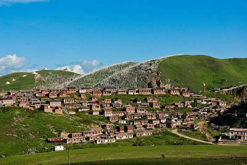 Tagong Grassland and Tagong Monastery (塔公草原与塔公寺), Kangding. Photograph: "Tagong22".
Tagong Grassland and Tagong Monastery塔公草原与塔公寺
Tagong is a grassland and a Sakya monastery on the Upper Muya pasture north-west of Kangding city, in Garze Tibetan Autonomous Prefecture, Sichuan, with Yala Snow Mountain rising beyond the grass to the north-west.
Read the place guide →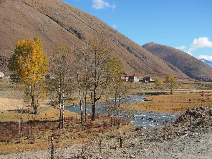 Autumn riverside scenery near Xinduqiao town, Kangding, Garze Tibetan Autonomous Prefecture · 甘孜藏族自治州康定市新都桥秋景 Source-recorded photograph date: Taken on 26 October 2012.
Xinduqiao Town新都桥
Xinduqiao is a town in the west of Kangding city, Garze Tibetan Autonomous Prefecture, Sichuan, 76 km from the city centre at the junction of National Highways 318 and 248, with its settlement standing at 3,460 metres.
Read the place guide →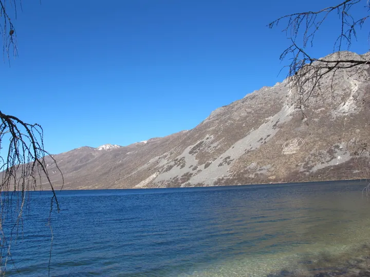 The deep blue waters of Mugecuo Lake with surrounding mountains, Kangding City, Garze Prefecture. · 甘孜州康定市木格措湖水及周边群山。 Source-recorded photograph date: Taken on 24 November 2012.
Mugecuo Lake木格措
Snow-fed alpine lake near Kangding, Sichuan, with Seven-Colour Lake, boiling medicine springs and an azalea gorge.
Read the place guide → AI illustration · AI 示意图(仅供参考,非该地点实拍)
Zheduo Mountain Official Viewpoints折多山沿线正规观景点
Zheduoshan is the mountain west of Kangding town, in Garze Tibetan Autonomous Prefecture, Sichuan, that the Sichuan-Tibet highway crosses on its way onto the plateau, rising to 4,298 metres; the catalogue name points to the official viewing points along that road rather than to any separate site.
Read the place guide →Plan your visit
Getting there
Kangding is about 6 km in a straight line from central Garzê Tibetan Autonomous Prefecture. Search for 康定市 in a map app to find stations and your accommodation.
Where to stay →Build your route
Tagong Grassland and Tagong Monastery and Xinduqiao Town are both listed here. The linked place guides have entrance and visit details.
Continue with Garzê Tibetan Autonomous Prefecture →More in Garzê Tibetan Autonomous Prefecture
Sources & geographic information
Administrative names and parent areas: Official geographic directory · Reference date 2026-09-06.
Some facts checked against 康定市 — Wikipedia contributors, CC BY-SA 4.0.
Some facts checked against 木格措 — Wikipedia contributors, CC BY-SA 4.0.
Some facts checked against 塔公寺 — Wikipedia contributors, CC BY-SA 4.0.
Some facts checked against 新都桥镇 — Wikipedia contributors, CC BY-SA 4.0.
Photo: Tagong Grassland and Tagong Monastery · Antoine Taveneaux · CC BY-SA 3.0. Full frame retained; EXIF orientation normalized, proportionally resized to at most 800 pixels and converted to WebP. No generated pixels or subject changes. Cards may crop the display.

Photo: Xinduqiao Town · rheins · CC BY 3.0. Full frame retained; proportionally resized and converted to WebP. No retouching or changes to the photographed subject. Card displays may crop the view.

Photo: Mugecuo Lake · Nyx Ning · CC BY-SA 3.0. Full frame retained; proportionally resized and converted to WebP. No retouching or changes to the photographed subject. Card displays may crop the view.

Map data © OpenStreetMap contributors. Pins mark approximate centres, not entrances or boundaries.