


Get to know Baoxing County
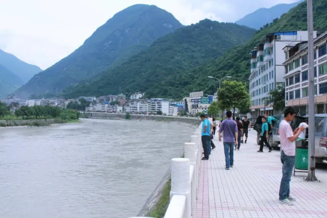
Photo adjustments
Full frame retained; proportionally resized and converted to WebP. No retouching or changes to the photographed subject. Card displays may crop the view.
- Administrative area
- County · 县
- Part of
- Ya'an
- Chinese name
- 宝兴县
- Local areas
- County guide
Area & population
- Area in the source
- 3,114.00 km²
- Population · 2020 census
- 48,040
- Administrative seat
- Muping Town
Source: cited geographic source, as of the dates shown.
Setting and landscape
The county lies in the Qionglai Mountains (邛崃山), falling from Shilama Mountain (石喇嘛山, 5,328 m) in the northwest to 750 m at the Lingguan gorge (灵关峡口). The Baoxing River, the main source of the Qingyi, rises on the southern slopes of Jiajin Mountain (夹金山) and meets its largest tributary, the Xi River, at Lianghekou (两河口) in the county town. The county government says 81.7 percent of the county falls within Giant Panda National Park, and it lists the wild osmanthus stand in the Donglashan canyon (东拉山大峡谷) in Longdong (陇东镇) as the largest in the world.
History
The county government places the ancient Qingyi Qiang (青衣羌) state here; from the late Yuan the area was ruled by hereditary chieftains, and the county was created in 1929, its name taken from the phrase "宝藏兴焉" ("treasures arise") in the Doctrine of the Mean. In 1869 the French missionary Armand David found and named the giant panda at Dengchigou (邓池沟) in Fengtongzhai (蜂桶寨乡). Jiajin Mountain was the first great snow mountain the Central Red Army crossed on the Long March, and the county marks it as the starting point of the snowy mountains and grasslands section of the Long March National Cultural Park.
What to see
At Dengchigou the Giant Panda Origin Museum (大熊猫起源馆) tells the story of the animal's discovery. The Memorial Hall of the Red Army Crossing Jiajin Mountain (红军长征翻越夹金山纪念馆) and an exhibition hall on Chen Yun's departure from Sichuan (陈云出川史实陈列馆) recall the Long March. Shenmulei (神木垒) is a primeval forest with ski runs and winter rime, and Dawa Gengzha (达瓦更扎), whose viewing platform the county government calls the largest 360-degree platform in Asia, is visited for sunrise over a sea of clouds. The Baokang road (宝康路) runs from Baoxing to Kangding past the Donglashan canyon.
Food and local products
Baoxing white marble (宝兴白) is the best known of more than 30 marble and granite varieties found here; the county government ranks it alongside Italian Carrara white. Baoxing ox-knee root (宝兴川牛膝), the dried root of Cyathula officinalis, is a Chinese geographical-indication product. For the Tibetan village of Qiaoqi (硗碛), the county's winter guide recommends Qiaoqi-style Tibetan hotpot and yak hotpot.
Getting oriented
Baoxing borders Lushan (芦山) to the east, Tianquan (天全) to the south, Kangding (康定) to the west, Xiaojin (小金) to the north and Wenchuan (汶川) to the northeast, and lies about 200 km from Chengdu.
Highlights
- Dengchigou 蜂桶寨邓池沟: Where Armand David found and named the giant panda in 1869; home of the Giant Panda Origin Museum.
- Jiajin Mountain 夹金山: First great snow mountain crossed by the Central Red Army on the Long March.
- Shenmulei 神木垒: Primeval forest with ski runs and winter rime.
- Dawa Gengzha 达瓦更扎: Mountain viewpoint for sunrise over a sea of clouds.
- Baoxing white marble 宝兴白: The county's best-known stone, ranked by the county alongside Carrara white.
Sources for this guide
走进宝兴 - 宝兴县人民政府 · Baoxing County People's Government
资源简介 - 宝兴县人民政府 · Baoxing County People's Government
冬日宝兴私藏攻略!四条绝美路线,一键打包熊猫、雪山、藏寨与长征故事 · Baoxing County People's Government
宝兴县 · Wikipedia (Chinese) · CC BY-SA 4.0
Original English written from the listed sources and checked sentence by sentence against quoted extracts by a separate reviewer. Updated 2026-09-25.
Explore Baoxing County
Core places to explore, with English and Chinese names.
Places to explore around Baoxing County
 Shenmulei Scenic Area · 神木垒
Shenmulei Scenic Area神木垒
Shenmulei is a forest and high-meadow scenic area in Baoxing County, Ya'an, in western Sichuan, listed by the county under the joint name Qiaoqi Tibetan Village / Shenmulei after the Gyarong Tibetan township it shares its billing with.
Read the place guide →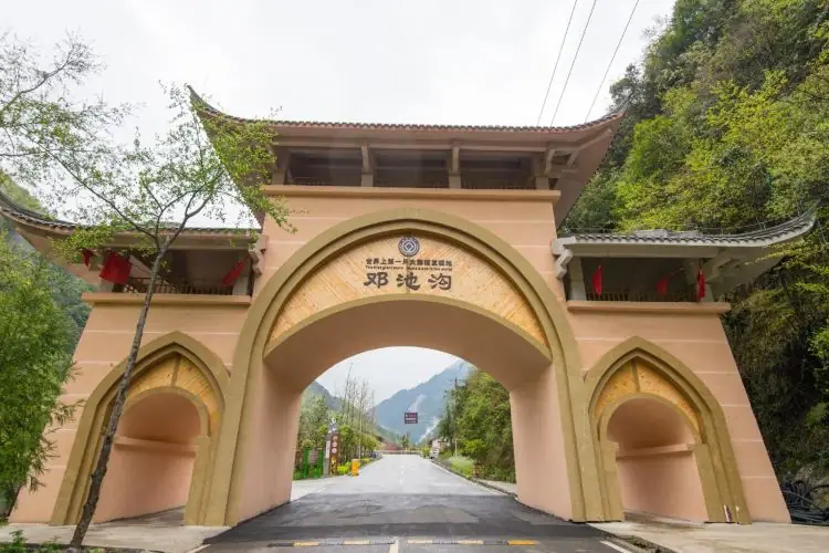 Fengtongzhai Dengchigou Village · 蜂桶寨邓池沟
Fengtongzhai Dengchigou Village蜂桶寨邓池沟
Fengtong Zhai Dengchi Gou is a village in Fengtong Zhai township, Baoxing County, Ya'an, in western Sichuan, and the core zone of the national-level Fengtong Zhai nature reserve, which the Ministry of Ecology and Environment registers for Baoxing County at 39,039 hectares. It is where the French missionary and biologist Armand David discovered the world's first live giant panda in 1869, and where the French Foreign Missions had built a Catholic church in 1839 combining western-Sichuan courtyard style with European Gothic elements.
Read the place guide →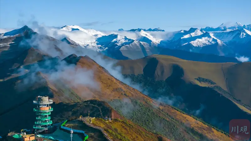 Dawagengzha Scenic Area · 达瓦更扎
Dawagengzha Scenic Area达瓦更扎
Dawagengzha is a high viewpoint in Baoxing County, Ya'an, in western Sichuan, whose Tibetan name means 'beautiful sacred mountain' and whose summit looks out over three separate ranges.
Read the place guide →Plan your visit
Getting there
Baoxing County is about 70 km in a straight line from central Ya'an. Search for 宝兴县 in a map app to find stations and your accommodation.
Where to stay →Build your route
Shenmulei Scenic Area and Fengtongzhai Dengchigou Village are both listed here. The linked place guides have entrance and visit details.
Continue with Ya'an →More in Ya'an
Sources & geographic information
Administrative names and parent areas: Official geographic directory · Reference date 2026-09-06.
Some facts checked against 宝兴县 — Wikipedia contributors, CC BY-SA 4.0.
Photo: Shenmulei Scenic Area · Source photographer · License not provided. EXIF orientation normalized; resized without changing aspect ratio; converted to WebP. No subject edits.
Photo: Fengtongzhai Dengchigou Village · Source photographer · License not provided. EXIF orientation normalized; resized without changing aspect ratio; converted to WebP. No subject edits.
Photo: Dawagengzha Scenic Area · Source photographer · License not provided. EXIF orientation normalized; resized without changing aspect ratio; converted to WebP. No subject edits.
Map data © OpenStreetMap contributors. Pins mark approximate centres, not entrances or boundaries.