

Explore the region
Tap any red Chinese text to hear it in Mandarin.
What makes it different
Tashkurgan is best understood as a base and a place with its own texture, rather than as a name for every Pamir stop. The county government identifies the area as a Tajik autonomous county in Kashgar Prefecture and describes the county as a high plateau crossed by China National Highway 314. In the town, the mountain basin, river and open sky matter as much as the surviving walls: the setting explains why this was a route through the Pamir and why the modern settlement is a useful overnight base.
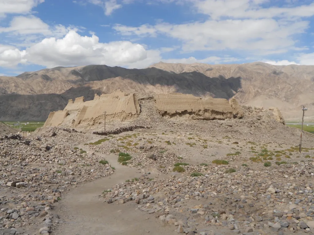
The name is linked to the stone fortress north of town. The ruins sit on a steep isolated hill on the left bank of the Tashkurgan River. From the protected route, look for the remaining inner-city walls, gates and raised platforms, then turn outward to the Pamir ridges and wetland. This is a ruin to read through its position and fragments, not a place to climb over; the county’s own visitor note asks visitors to stay on the wooden walkway and move slowly at altitude.
See the town and the nearby scenic area
The official Pamir Tourism Area lies in the northeast of the county seat and brings together Stone City, the Golden Grassland wetland and the Caiyun Renjia folk village. Its visitor infrastructure is described as an internal shuttle loop, walking paths and wetland boardwalks. Treat that loop as the scenic area’s own circulation, not as a county-wide bus. Date-specific opening hours, ticket products and current shuttle times should be checked with the venue before departure.
Golden Grassland changes with the season: the county government describes green wetland meadows in summer, yellow vegetation in autumn and a snow-covered winter landscape. The river channels and open wetland make it a place for a slow walk and wide views rather than a checklist of structures. Keep to marked paths and leave space for residents, herders and wildlife. The scenic area’s folk-village component may offer food, accommodation or cultural interpretation, but this guide does not treat a particular meal, performance or household as guaranteed daily programming.
Getting there and back
By road: China National Highway 314 (G314), the China–Pakistan Highway, crosses the county. From Kashgar, arrange a road service to 塔什库尔干塔吉克自治县县城 Tǎshíkù’ěrgān Tǎjíkè Zìzhìxiàn Xiànchéng or 塔什库尔干镇 Tǎshíkù’ěrgān Zhèn, and for the organised attraction use 帕米尔旅游区游客服务中心 Pàmǐ’ěr Lǚyóuqū Yóukè Fúwù Zhōngxīn or the named 石头城遗址景区 Shítouchéng Yízhǐ Jǐngqū entrance. The county government gives the county-seat area as about 290 km from Kashgar City, but this is not a timetable or a guaranteed travel time. Current public-coach departures and fares were not confirmed in the sources used here, so do not rely on an unbooked last return. Confirm the outbound and return road service before leaving Kashgar.
By air: The real airport name is 塔什库尔干红其拉甫机场 (Tashkurgan Hongqilafu Airport). The Civil Aviation Administration recorded the airport’s opening and the Urumqi–Tashkurgan route in 2022; a 2024 report also documented a Chengdu Airlines flight from the airport to Kashgar. These are evidence that the airport and routes have operated, not a promise of a flight on your date. Check a live airline listing, then arrange the road transfer from the airport to 塔什库尔干镇 Tǎshíkù’ěrgān Zhèn; no current public airport-to-town shuttle timetable was confirmed here.
The town is in a border county, but a stay in Tashkurgan does not automatically make a border stop part of the same visit. 红其拉甫国门 Hóngqílāfǔ Guó Mén is a separate, high-altitude destination described by the county as 126 km from the county seat. Add it, or any other remote border or mountain road, only after the specific route’s current entry permissions, passport-document requirements and return transport have been confirmed with the responsible operator or local authority. Do not assume that a permit for one place applies to another.
Combine your visit
Choose from these complementary stops when planning your visit.
-
Stone Fortress石头城
Begin with the permitted archaeological route.
-
Town and basin views县城与盆地景观
Explore the public spaces around your base.
-
Planned Pamir continuation计划中的帕米尔后续行程
Add only the road sections and stops whose access has been confirmed.
This is a suggested combination, not a timed route; confirm the opening and transport arrangements for your date.
Find Tashkurgan
塔什库尔干 · 塔什库尔干塔吉克自治县
The pin marks the area, not the entrance.
More places nearby
Approximate straight-line distances between map pins, not travel distances.
Muztagh Ata 慕士塔格峰
57 km awayMuztagh Ata is a heavily glaciated mountain in the eastern Pamir region. Its broad snow-covered profile is a defining view from the Karakul and Karakoram Highway area. The mountain’s presence can be appreciated from authorised…
View guide →Karakul (China) 喀拉库勒湖
76 km awayKarakul in Akto County is a high-altitude lake beside the Karakoram Highway, with Muztagh Ata and the Kongur mountain group forming its wider setting. Still conditions can create striking reflections, while wind changes the…
View guide →Khunjerab Pass 红其拉甫口岸
104 km awayKhunjerab is the high international crossing between China and Pakistan on the Karakoram Highway. The snow-and-rock landscape and border gate are its principal visual features, but sightseeing at the Chinese gate and crossing…
View guide →Sources & visit information
Sources checked on 25 October 2026. Hours, tickets, reservations and transport can change; confirm with the operator before you go.
Image credits & notes (1)
- Stone City ruins at Tashkurgan, with the Pamir mountains behind Photo: DrgklPhoto: Creative Commons Attribution-ShareAlike