


Get to know Xianggelila
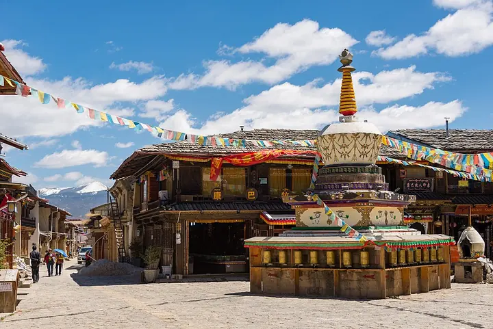
Photo adjustments
Full frame retained; proportionally resized and converted to WebP. No retouching or changes to the photographed subject. Card displays may crop the view.
- Administrative area
- County-level city · 县级市
- Part of
- Diqing Tibetan Autonomous Prefecture
- Chinese name
- 香格里拉市
- Local areas
- County-level city guide
Area & population
- Area in the source
- 11,613.00 km²
- Population · 2020 census
- 186,412
Source: cited geographic source, as of the dates shown.
History
Until 2001 the place was called Zhongdian (中甸); its Tibetan name is rendered in Chinese as Jiantang (建塘). James Hilton's 1933 novel Lost Horizon described a secluded paradise called Shangri-La, and the Ministry of Civil Affairs approved the renaming of Zhongdian County as Shangri-La County on 17 December 2001. The county became a city on 16 December 2014. Yunnan listed it as a provincial historic and cultural city in 2002.
The Dukezong old town (独克宗古城) in Jiantang town (建塘镇), the city seat, traces its origins to 634, when Tibetan troops under Songtsen Gampo (松赞干布) built an official stronghold on Dagui Hill (大龟山). It was a garrison and a relay station on the Tea Horse Road. When the Japanese invasion of Burma cut the Yunnan-Burma route in the war against Japan, goods crossed the Himalayas from Lhasa to Kunming and the town became a transfer point for Yunnan-Tibet-India trade. A fire struck the old town on 11 January 2014; rebuilt, it reopened on 1 January 2016.
Setting and landscape
The city stretches 88 kilometres east to west and 218 kilometres north to south; across the Jinsha River (金沙江) to the south-east lie Yulong (玉龙), Weixi (维西) and Deqin (德钦). Forest covers 78.6 percent of the land, and Haba Snow Mountain (哈巴雪山), Bita Lake (碧塔海) and Napa Lake (纳帕海) are provincial nature reserves.
What to see
Pudacuo National Park (普达措国家公园) holds two plateau lakes, Shudu (属都海) and Bita. Near the city stands Songzanlin Monastery (松赞林寺), also called Guihua Temple and nicknamed the "little Potala"; the prefecture government counts it among the thirteen great monasteries of Kham. Baishuitai (白水台) is described by the prefecture as the birthplace of Dongba culture (东巴文化). Tiger Leaping Gorge town (虎跳峡镇) is one of the city's townships, and the prefecture lists the gorge among its main sights. Nine long-settled peoples live in the city, including Tibetans, Naxi, Lisu and Yi, and Tibetan Buddhism, Catholicism, Protestantism, Islam, Bon and the Dongba religion are all practised.
Food and local products
The Diqing prefecture government names butter tea, cheese curds, tsampa, buckwheat cakes and highland barley liquor as local foods, with yak meat and pipa meat (琵琶肉) the best known. Pipa meat, cured in the Tibetan way, is a pig with its organs and bones removed, seasoned with Sichuan pepper, black cardamom (草果) and salt, sewn up and cured under stone slabs; it is named for its pipa-like shape.
Highlights
- Dukezong old town 独克宗古城: Old Tea Horse Road town in Jiantang, dating back to 634; rebuilt after the 2014 fire.
- Songzanlin Monastery 松赞林寺: Tibetan Buddhist monastery near the city, nicknamed the "little Potala".
- Pudacuo National Park 普达措国家公园: National park with the plateau lakes Shudu and Bita.
- Baishuitai 白水台: Described as the birthplace of Dongba culture.
- Napa Lake 纳帕海: Provincial nature reserve.
- Pipa meat 琵琶肉: Pig cured under stone slabs in the Tibetan way, shaped like a pipa.
Sources for this guide
香格里拉市总体概况 · Shangri-La Municipal People's Government
香格里拉市 - 维基百科,自由的百科全书 · Wikipedia (Chinese) · CC BY-SA 4.0
旅游资源 · Diqing Tibetan Autonomous Prefecture People's Government
独克宗古城 - 维基百科,自由的百科全书 · Wikipedia (Chinese) · CC BY-SA 4.0
Original English written from the listed sources and checked sentence by sentence against quoted extracts by a separate reviewer. Updated 2026-09-25.
Explore Xianggelila
Core places to explore, with English and Chinese names.
Places to explore around Xianggelila
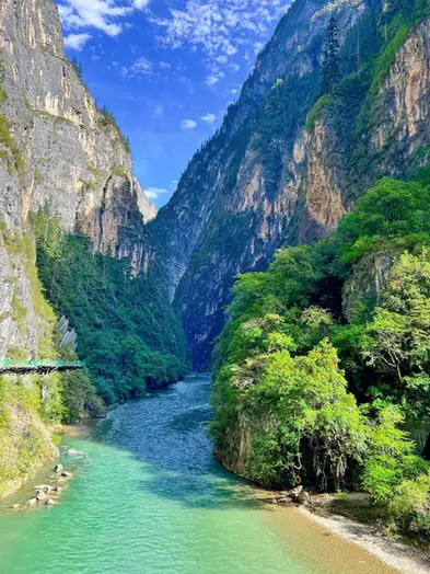 Balagezong Scenic Area · 巴拉格宗
Balagezong Scenic Area巴拉格宗
Balagezong Scenic Area is a scenic area in Xianggelila (Shangri-La), Yunnan, centred on the 'Tianlu 108' access road -- cut into the mountainside over ten years by local Khampa Tibetan Sina Dingzhu -- which links a millennium bodhi tree, the Shangri-La Grand Canyon, Bala village and the Shambhala stupa.
Read the place guide → A wooden boardwalk trail through forest along the shore of Bita Lake, Pudacuo National Park · 普达措国家公园碧塔海木栈道,穿行于湖畔森林间 Source-recorded photograph date: Taken on 31 May 2013.
Potatso National Park普达措
Highland park in Shangri-La with Shudu and Bita lakes, fir forest and meadow, approved in 2006 by Yunnan forestry officials as a national park.
Read the place guide →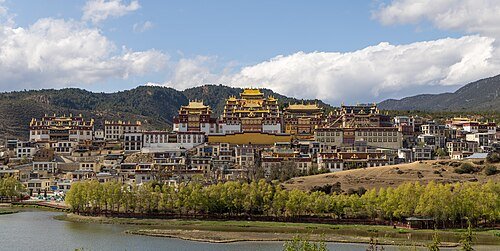 Songzanlin Monastery · 松赞林寺
Ganden Sumtseling Monastery松赞林寺
Songzanlin Monastery climbs a hillside north of Shangri-La, with its principal halls rising above the surrounding monastic buildings. The arrangement makes the complex look layered when seen from below. Zacang Hall and the…
Read the place guide → The East Gate archway of Dukezong Ancient Town, with the old town's street visible beyond, Shangri-La City, Diqing. · 迪庆州香格里拉市独克宗古城东门牌楼,可见古城街道。 Source-recorded photograph date: 2026-02-25 12:03:34.
Dukezong Ancient City独克宗古城
Shangri-La's Tibetan old town, dating from 634, a Tea Horse Road staging post rebuilt after a 2014 fire, with a hilltop temple and giant prayer wheel.
Read the place guide → Baishuitai Travertine Terraces (白水台), Xianggelila. Photograph: "1 baishuitai 2018 aerial pano 2018".
Baishuitai Travertine Terraces白水台
Baishuitai Travertine Terraces is a travertine terrace formation at Baidi village, Sanba township, Xianggelila (Shangri-La), Yunnan, regarded locally as the birthplace of Naxi Dongba culture and covering about 3 sq km at 2,380 m elevation.
Read the place guide → Wetland channels of Napa Lake with mountains beyond, Shangri-La · 香格里拉纳帕海湿地与远山 Source-recorded photograph date: 2025-05-07 18:49:07.
Napa Lake纳帕海
Seasonal highland lake near Shangri-La that turns into Yila Grassland in winter, the main wintering ground of the central black-necked crane population.
Read the place guide →Plan your visit
Getting there
Xianggelila covers the centre of Diqing Tibetan Autonomous Prefecture. Search for 香格里拉市 in a map app to find stations and your accommodation.
Where to stay →Build your route
Balagezong Scenic Area and Potatso National Park are both listed here. The linked place guides have entrance and visit details.
Continue with Diqing Tibetan Autonomous Prefecture →More in Diqing Tibetan Autonomous Prefecture
Sources & geographic information
Administrative names and parent areas: Official geographic directory · Reference date 2026-09-06.
Some facts checked against 香格里拉市 — Wikipedia contributors, CC BY-SA 4.0.
Some facts checked against 独克宗古城 — Wikipedia contributors, CC BY-SA 4.0.
Photo: Balagezong Scenic Area · Source photographer · License not provided. EXIF orientation normalized; resized without changing aspect ratio; converted to WebP. No subject edits.
Photo: Potatso National Park · fish4fish · CC BY-SA 3.0. Full frame retained; proportionally resized and converted to WebP. No retouching or changes to the photographed subject. Card displays may crop the view.

Photo: Ganden Sumtseling Monastery · 瑞丽江的河水 · CC BY-SA 4.0. Wikimedia thumbnail; fitted to the ranking-card frame.
.jpg)
Photo: Dukezong Ancient City · 祝鱼贵 · CC BY-SA 4.0. Full frame retained; proportionally resized and converted to WebP. No retouching or changes to the photographed subject. Card displays may crop the view.

Photo: Baishuitai Travertine Terraces · Chensiyuan · CC BY-SA 4.0. Full frame retained; EXIF orientation normalized, proportionally resized to at most 800 pixels and converted to WebP. No generated pixels or subject changes. Cards may crop the display.

Photo: Napa Lake · 瑞丽江的河水 · CC BY-SA 4.0. Full frame retained; proportionally resized and converted to WebP. No retouching or changes to the photographed subject. Card displays may crop the view.

Map data © OpenStreetMap contributors. Pins mark approximate centres, not entrances or boundaries.