


Get to know Wuhe County
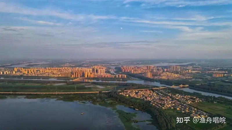
Photo adjustments
EXIF orientation normalized; resized without changing aspect ratio; converted to WebP. No subject edits.
- Administrative area
- County · 县
- Part of
- Bengbu
- Chinese name
- 五河县
- Local areas
- County guide
Area & population
- Area in the source
- 1,580.00 km²
- Population · 2020
- 523,531
Source: cited geographic source, as of the dates shown.
Setting and landscape
The Huai crosses the county from west to east. The county town is ringed by water, with rivers running through it, earning it the name "water town of northern Anhui" (皖北水乡). The hills of the Mount Dagong (大巩山) provincial forest park have about 80 percent forest cover, and the Tuo Lake (沱湖) provincial nature reserve is the core of a wetland of fish, crabs and birds. Other scenic waters include Xiangjian Lake (香涧湖), Tianjing Lake (天井湖) and the Qiaozijian Reservoir (樵子涧水库).
History
At Xiyou village in Shuangzhongmiao town (双忠庙镇), a fossil of an ancient Huai River straight-tusked elephant about 100,000 years old was found; the county describes it as the most complete in China. From Qin and Han times the area belonged to Hong County (虹县), whose seat stood inside present Wuhe until it moved away in 639. Wuhe County was created in 1271 under the Southern Song. It came under Fengyang prefecture (凤阳府) in 1374 and has been part of Bengbu since 1 July 1983.
What to see
The Huamingtang Yan family tomb (化明塘严氏墓), 500 metres south-east of Huamingtang village in Xiaoxi town (小溪镇) beside National Highway 104, was begun in 1374 and became a national key protected site in 2013. It faces south from the southern end of Mount Dagong. A 30-metre spirit way survives with an uninscribed stele and pairs of stone officials, tigers, sheep and horses, and bricks from the site are stamped "seventh year of Hongwu" and "made by Zhenjiang prefecture". Local legend says Miss Yan hid Zhu Yuanzhang (朱元璋) from Yuan soldiers and died unmarried waiting for him, so he buried her with the rites of a first-rank lady; a single phoenix on the stele head marks her unmarried state.
Wuhe folk songs, led by "Picking Pomegranates" (摘石榴), are on the national intangible cultural heritage list, and Shunhe Street (顺河街) is a listed historic and cultural street of Anhui.
Food and local products
Wuhe crabs, the county's best-known product, carry a national geographical indication for agricultural products and were named one of China's ten famous crabs in 2004. On Tuo Lake, which covers some 80,000 mu, young crabs are stocked in spring and grow free-range for more than half a year; in 2021 the catch opened on 23 September with the fourth Wuhe crab festival.
Getting oriented
National Highway 104 runs north to south through the county, and the Xuzhou–Mingguang expressway (徐明高速) has an exit on the west side of the county town.
Highlights
- Huamingtang Yan family tomb 化明塘严氏墓: Ming tomb begun in 1374 with a spirit way of stone figures; national key protected site since 2013.
- Mount Dagong Forest Park 大巩山省级森林公园: Provincial forest park with about 80 percent forest cover.
- Tuo Lake 沱湖: Provincial nature reserve and home of the Tuo Lake crab catch.
- Wuhe crabs 五河螃蟹: Geographical-indication crabs, named one of China's ten famous crabs in 2004.
- Wuhe folk songs 五河民歌: National intangible cultural heritage, represented by "Picking Pomegranates".
Sources for this guide
地区简介_五河县人民政府 · Wuhe County People's Government
历史沿革_五河县人民政府 · Wuhe County People's Government
化明塘严氏墓_五河县人民政府 · Wuhe County People's Government
安徽五河:沱湖螃蟹开捕 · Anhuinews (中安在线), Anhui provincial news portal
Original English written from the listed sources and checked sentence by sentence against quoted extracts by a separate reviewer. Updated 2026-09-23.
Explore Wuhe County
Core places to explore, with English and Chinese names.
Wuhe County 五河县
Plan your visit
Getting there
Wuhe County is about 50 km in a straight line from central Bengbu. Search for 五河县 in a map app to find stations and your accommodation.
Where to stay →More in Bengbu
Sources & geographic information
Administrative names and parent areas: Official geographic directory · Reference date 2026-09-06.
Map data © OpenStreetMap contributors. Pins mark approximate centres, not entrances or boundaries.