

Explore the region
A Huizhou hamlet of about fifty households balanced on a ridge in Xiuning County, with sheer drops on three sides, cloud seas below on many mornings of the year, and no road in: the last stretch is a climb of about 800 steps.
Mulihong (木梨硔, pronounced roughly mù lí hóng) is a natural village on the shoulder of Kuzhujian (苦竹尖) in Huaqiao village (花桥村), Xikou town (溪口镇), Xiuning County, Huangshan City. The ground falls away on three sides, cars stop below, and the last stretch is on foot. It was added to the national register of Chinese Traditional Villages in the second batch of 915, published on 26 August 2013. English-language coverage from Xinhua has settled on calling it the “Village in the Clouds”.
The village on the ridge
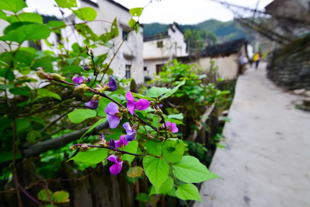
Seen from Qianshan (前山, “the front hill”) — the slope directly opposite, planted with tea and bamboo — the settlement reads as the outline of a camel, which is how villagers and the local architecture literature describe it; the People’s Daily writer saw a horse or a camel. The houses are Huizhou work: whitewashed walls, grey-dark tiles, and rows that step up the slope from south to north, so that each roofline sits below the one behind it.
Two details separate Mulihong from the lowland Huizhou villages. First, the horse-head walls (马头墙) that give Hongcun and Xidi their sawtooth skylines are deliberately kept low here, a design choice made to cut wind resistance on an exposed ridge. Second, many of the village’s lanes are not lanes at all but suspended drying platforms — 晒台 (shài tái) — built out over the cliff on logs, where you can walk and sit, and where families spread crops, cured pork and cured fish in autumn. People’s Daily describes the same thing: log-supported terraces hung over the drop, with tables set on them and cured meat and fish laid out to dry.
The name is usually explained through the timber trade. Logs were dragged down the mountain through a deep gully whose scar looked like a plough furrow, giving 木犁 (“wooden plough”) village, later written 木梨硔; 硔 means a deep gully or gorge, and there is one directly below the village. The same accounts say the founding family arrived in the Wanli era of the Ming — Chinese Wikipedia gives the fifteenth year, 1587 — fled a family disaster and changed its surname to Zhan (詹), which most residents still carry. A stone wall at the entrance carries the village name.
Sources count 52 households and 166 residents, and the traditional-architecture platform of Hefei University of Technology uses the same figures; a 2024 news report gives 49 households. Many working-age adults are away, and the village lives on forestry, tea and a few terraced plots of rapeseed and rice — plus, increasingly, guests.
Cloud seas, and how to watch them
The cloud sea is the reason most people come. Damp air piles up against the ridge, and after rain the valley below the village fills with cloud while the ridge itself stays clear. Chinese Wikipedia puts the frequency at about one day in three across the year; a 2024 Xinmin Evening News report says half the year. Treat any figure as an average, not a promise: it is mountain weather, and it does not appear to order. Xinhua photographed another cloud sea filling the village after autumn rain in early October 2026.
The standard viewing position is the platform on Qianshan, the hill opposite the village, where the whole camel-shaped settlement is visible with the cloud below it; People’s Daily describes photographers taking their places on the ridge at four or five in the morning. You can also watch from the terraces and drying platforms inside the village, which face the valley and the sunrise. Spring (March–April) adds terraced rapeseed around the houses; autumn adds colour and the drying racks; on clear nights there is almost no light pollution, so the Milky Way is visible.
The climb
There is no road to the village, and this is the part to plan for. Cars reach the foot of the mountain, where the last stretch is a climb of about 800 steps — People’s Daily counts “eight hundred and eighty-odd” — laid mostly as fir logs set horizontally across the slope, so the tread is a rounded log rather than a flat stone. The Anhui news service, describing the same climb, gives 800 steps and about 20 minutes; with a bag, allow 30–40. There are rest pavilions on the way up, with spring water at hand. The path is steep and slick after rain, so carry a backpack rather than a wheeled suitcase, and ask your guesthouse whether someone can carry luggage up.
In late 2025 the county was finishing a project to harden and widen the last kilometre of the mountain road to the trailhead — 1 km, 5.5 m roadbed, concrete surface. It makes the drive to the car park easier; it does not put a road into the village itself, and Chinese Wikipedia still describes Mulihong as the only village in Huangshan City without road access.
Tickets, hours and what to book
There is no ticket gate, no opening hours and nothing to reserve to walk up: this is a lived-in village, not a walled scenic area. Trip.com’s attraction listing records free admission, and none of the reports of visiting the village between 2023 and 2025 mention an entrance fee.
What does need arranging is the room and the car. Almost every household takes guests — 31 farm-stays were counted in 2023 and 32 in 2024 — and on national holidays the village fills up completely; a 2024 National Day report found every room taken. People’s Daily put the village’s 2022 total at more than 200,000 visitors and tourism income above ¥10 million, which is the scale of the change on this ridge. Rooms are simple farmhouse style, usually with breakfast and dinner available; names seen on doors include 八仙客栈 (Baxian, operating since 2011), 山海之家, 老木匠客栈, 浙嫁徽, 云巅 and 徽居, and there is a village coffee shop, 木梨花开咖啡馆, plus 云边咖啡. Recent visitor write-ups mention a small parking charge at the foot of the mountain (around ¥10 a day); it is not published officially, so treat it as approximate.
Getting there
There is no metro in Xiuning County or in Xikou town, so ignore any itinerary that mentions one. The practical route is high-speed rail, then county buses, then the steps.
By rail and bus. Arrive at 黄山北站 (Huangshan North Railway Station). County bus 106 or 5001 runs from the station to 休宁客运西站 (Xiuning West Bus Station, Xiuning Keyun Xizhan). From there, bus 201 goes to 溪口集散中心 (Xikou town), and bus 202 — running on to 樟前 (Zhangqian) — has a stop named 木梨硔山口 (Mulihong shankou, “Mulihong mountain entrance”), between 界首 and 花桥, which is the stop for the trailhead below the village; the same bus continues to 板桥乡政府 (Banqiao). The operator, Xiuning Public Transport, publishes route lists and departure times on its own site; the times are posted as images and could not be read reliably for this article, so check the day’s departures at 休宁客运西站 or with your guesthouse, and confirm the last return bus before you climb.
By taxi or ride-hailing. Give the driver the Chinese destination 木梨硔山口 or 木梨硔停车场, in 溪口镇, 休宁县 — the trailhead and car park below the village, near the 詹家山 junction. From 黄山北站, recent visitor write-ups describe a taxi or shared car to Xikou taking roughly 40 minutes; treat that as indicative rather than fixed. There is no taxi rank at the trailhead, so arrange the return car in advance, usually through the guesthouse.
By car. Drive to 溪口镇 and then up the mountain road to the foot of the steps; the final kilometre was hardened and widened in the 2025–26 project. Parking is at the foot of the steps, and everything above it is on foot.
If you have more time
The 梦里古道 (Mengli Guda, “Dream Ancient Trail”) links Mulihong with Zuyuan village (祖源村) across the ridge — hikers commonly describe about 5 km and two hours one way, longer with a pack, through bamboo, tea and pine. Zuyuan is another of the county’s photography villages, with a very old yew tree. Both villages sit on ridges, so the walk has climbs in both directions.
The same bus 202 passes a stop called 呈村百佳摄影点 — “Chengcun, one of the hundred best photography spots” — a reminder that Huangshan City keeps a formal list of photo spots, on which Mulihong also appears. Bus 1 from 休宁客运西站 runs to 齐云山 (Qiyun Mountain), the Danxia peak with a cliff-top village, if you want to pair the ridge hamlet with a more conventional site.
Find Mulihong Village
木梨硔 · 休宁县
The pin marks the area, not the entrance.
Sources & visit information
Sources checked on 22 October 2026. Hours, tickets, reservations and transport can change; confirm with the operator before you go.
- 木梨硔 — 维基百科(中文) ↗
- 黄山市休宁县溪口镇花桥村木梨硔 — 合肥工业大学传统建筑平台 ↗
- 云端上的木梨硔 — 人民日报海外版,2025-03-13 ↗
- 苍苍竹林中云开现古村(寻找最美乡村·木梨硔村)— 人民日报,2023-07-05 ↗
- 住房城乡建设部 文化部 财政部关于公布第二批列入中国传统村落名录的村落名单的通知(建村〔2013〕124号)— 维基文库 ↗
- 休宁县:乡村旅游“热”力足 国庆假期木梨硔人气旺 — 中新网安徽,2024-10-04 ↗
- 古老山村,世外桃源:探秘黄山云端之上的木梨硔 — 新民晚报,2024-10-30 ↗
- 公交线路查询 — 休宁公共交通有限公司官方网站 ↗
- 60"FlyOverChina | Picturesque cloud-hugging village in E China's Anhui — Xinhua, 2025-11-03 ↗
- 安徽休宁:云端古村入画来 — 新华网长三角,2026-10-01 ↗
- 休宁县溪口镇:云端通道焕新颜 打通乡村发展路 — 安徽日报党媒云,2025-12-30 ↗
- Mulihong Village — Trip.com attraction listing and visitor guides ↗
- Mulihong Village in Huangshan — ETripChina ↗
Image credits & notes (1)
- The stone-paved path along Mulihong's north side, where whitewashed Huizhou houses step down the ridge. Photo: fish4fishPhoto: CC BY-SA 3.0