


Get to know Sunan Yugur Autonomous County
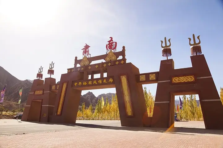
Photo adjustments
Full frame retained; resized proportionally to a maximum dimension of 960 pixels and converted to WebP quality 88. No crop, retouch, generated elements, or subject alteration. Final website rendition: full frame retained, proportionally resized to at most 720 pixels and converted to WebP. No additional retouching or subject alteration. Card displays may crop the view.
- Administrative area
- Autonomous county · 自治县
- Part of
- Zhangye
- Chinese name
- 肃南裕固族自治县
- Local areas
- Autonomous county guide
Area & population
- Area in the source
- 20,176.70 km²
- Population · 2020
- 27,762
- Administrative seat
- Hongwansi
Source: cited geographic source, as of the dates shown.
Setting and landscape
Sunan Yugur Autonomous County covers about 24,000 square kilometres and straddles 15 counties and districts in seven prefectures of Gansu and Qinghai. The county government calls it the largest component of the Qilian Mountains National Nature Reserve (祁连山国家级自然保护区), with 964 glaciers, and the Hei (黑河), Shiyang (石羊河) and Shule (疏勒河) rivers rise here. Its scenery ranges from snow peaks and glaciers through grassland and forest to desert, Gobi, deep gorges and Danxia landforms.
What to see
The Mati Temple (马蹄寺) grottoes lie 65 kilometres south of Zhangye city. First cut in the Northern Liang (北凉) of the Sixteen Kingdoms, more than 1,600 years ago, they form seven groups, among them Shengguo Temple (胜果寺), Jinta Temple (金塔寺) and the Thousand Buddha Caves (千佛洞). There are more than 70 niches; the "Thirty-Three Heavens" (三十三天) grotto stands out. They are a national key protected site.
The Wenshushan Grottoes (文殊山石窟), in Qifeng Tibetan Township (祁丰藏族乡), are also a national key protected site. They belong to the Liangzhou (凉州) model of early cave temples; 131 caves survive, among them eight early central-pillar caves, with about 370 square metres of murals, some from the Western Xia (西夏).
Binggou Danxia (冰沟丹霞), 45 kilometres west of Zhangye city and 41 kilometres east of the county seat, is part of the Zhangye Danxia National Geopark. Between 1,500 and 2,550 metres above sea level, its cliffs, rock walls, pillars and spires spread over 300 square kilometres, and the county names it the type locality of the sandstone "window-lattice" (窗棂状) structure.
Barse Snow Mountain (巴尔斯雪山) rises in Xichahe village (西岔河村) of Dahe township (大河乡), 28 kilometres from the county seat. Six peaks run east to west; the main summit, 5,118 metres high, is a sacred mountain to the Yugur, and glaciers, grassland, forest and a blue alpine lake lie below it.
Food and local products
Yugur households take tea two or three times a day and eat one proper meal, in the evening. The tea is stirred with butter, salt and fresh milk; with milk skin, qula (曲拉, dried curd), roasted flour or jujubes added it becomes breakfast. Mutton and beef come as hand-held meat (手抓肉), braised mutton strips and wind-dried mutton, while the "beizi" (背子), a whole rump boiled on the bone, and roast whole lamb are the finest dishes for guests and festivals. Rice may be sweetened with silverweed root (蕨麻), raisins, jujubes, sugar and butter.
Highlights
- Mati Temple grottoes 马蹄寺石窟: Seven cave groups with more than 70 niches, begun in the Northern Liang; national key protected site.
- Wenshushan Grottoes 文殊山石窟: 131 caves of the early Liangzhou model with about 370 square metres of murals, including Western Xia work.
- Binggou Danxia 冰沟丹霞: Danxia cliffs and pillars over 300 square kilometres in the Zhangye Danxia National Geopark.
- Barse Snow Mountain 巴尔斯雪山: Six-peak range with a 5,118-metre main summit sacred to the Yugur.
Sources for this guide
肃南裕固族自治县人民政府-肃南概况 · Sunan Yugur Autonomous County People's Government
肃南裕固族自治县人民政府-巴尔斯雪山 · Sunan County Bureau of Culture, Sports, Broadcasting and Tourism
肃南裕固族自治县人民政府-文殊山石窟 · Sunan County Bureau of Culture, Sports, Broadcasting and Tourism
肃南裕固族自治县人民政府-冰沟丹霞旅游景区 · Sunan County Tourism Bureau
肃南裕固族自治县人民政府-马蹄寺风景名胜区 · Sunan County Bureau of Culture, Sports, Broadcasting and Tourism
肃南裕固族自治县人民政府-食俗 · Sunan County Bureau of Culture, Sports, Broadcasting and Tourism
Original English written from the listed sources and checked sentence by sentence against quoted extracts by a separate reviewer. Updated 2026-09-25.
Explore Sunan Yugur Autonomous County
Core places to explore, with English and Chinese names.
Places to explore around Sunan Yugur Autonomous County
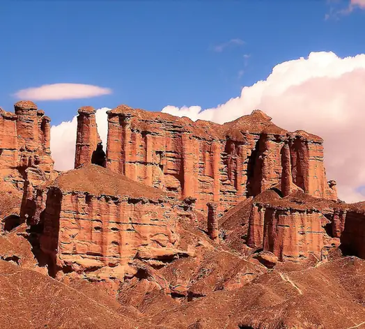 Binggou Danxia Scenic Area · 冰沟丹霞
Binggou Danxia Scenic Area冰沟丹霞
Binggou Danxia (冰沟丹霞) is a danxia landform area in Sunan Yugur Autonomous County, Zhangye, Gansu, and one of the main scenic areas of the Zhangye Danxia National Geopark.
Read the place guide →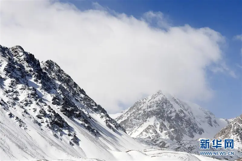 Barsi Snow Mountain Viewing Area · 巴尔斯雪山开放观景区
Barsi Snow Mountain Viewing Area巴尔斯雪山开放观景区
Barsi Snow Mountain (巴尔斯雪山) is a snow-mountain scenic area in Xichahe village, Dahe township, Sunan Yugur Autonomous County, Zhangye, Gansu, on the middle section of the Qilian Mountains' northern slope.
Read the place guide → Cliffside Buddhist cave-temple architecture at Mati Temple Grottoes, Gansu · 甘肃马蹄寺石窟崖壁建筑. Source-recorded photograph date: 2012-09-11 04:30:17.
Mati Temple Grottoes马蹄寺石窟
Buddhist cave temples begun under the Northern Liang in the Qilian foothills of Sunan, Gansu, with a 42 m five-tier cave and 37 caves in seven groups.
Read the place guide →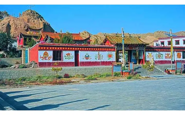 Wenshu Temple Grottoes · 文殊寺石窟
Wenshu Temple Grottoes文殊寺石窟
Wenshu Temple cave complex (文殊寺石窟群), also called Wenshu Mountain caves, is a Buddhist cave site on Wenshu Mountain in Qifeng Tibetan township, Sunan Yugur Autonomous County, Zhangye, Gansu, more than 20 km from both Jiuquan and Jiayuguan.
Read the place guide →Plan your visit
Getting there
Sunan Yugur Autonomous County is about 75 km in a straight line from central Zhangye. Search for 肃南裕固族自治县 in a map app to find stations and your accommodation.
Where to stay →Build your route
Binggou Danxia Scenic Area and Barsi Snow Mountain Viewing Area are both listed here. The linked place guides have entrance and visit details.
Continue with Zhangye →More in Zhangye
Sources & geographic information
Administrative names and parent areas: Official geographic directory · Reference date 2026-09-06.
Photo: Binggou Danxia Scenic Area · Source photographer · License not provided. EXIF orientation normalized; resized without changing aspect ratio; converted to WebP. No subject edits.
Photo: Barsi Snow Mountain Viewing Area · Source photographer · License not provided. EXIF orientation normalized; resized without changing aspect ratio; converted to WebP. No subject edits.
Photo: Mati Temple Grottoes · Immanuel Giel · CC BY-SA 3.0. Full source framing retained; proportionally resized and converted to WebP. No retouching or subject alteration. Card displays may crop the view.

Photo: Wenshu Temple Grottoes · Source photographer · License not provided. EXIF orientation normalized; resized without changing aspect ratio; converted to WebP. No subject edits.
Map data © OpenStreetMap contributors. Pins mark approximate centres, not entrances or boundaries.