


Get to know North District
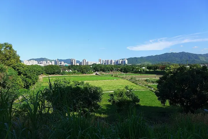
Photo adjustments
Full frame retained; proportionally resized and converted to WebP. No retouching or changes to the photographed subject. Card displays may crop the view.
- Administrative area
- District · 地區
- Part of
- Hong Kong
- Chinese name
- 北區
- Local areas
- District guide
Area & population
- Area in the source
- 168.00 km²
- Population · 2016
- 315,270
Source: cited geographic source, as of the dates shown.
Setting and landscape
The district is traditionally divided into four parts: Sheung Shui (上水), Fanling (粉嶺), Sha Tau Kok (沙頭角) and Ta Kwu Ling (打鼓嶺), and it also takes in islands in Mirs Bay (大鵬灣) such as Kat O (吉澳) and Ap Chau (鴨洲). A quarter of its area lies on the Fanling lowlands, crossed by the River Indus (梧桐河) and its tributaries. Long Valley (塱原), a rare freshwater wetland, is farmed as wet fields of water spinach and watercress.
Yan Chau Tong Marine Park (印洲塘海岸公園) protects habitat for many species, and Kat O and Yan Chau Tong were included in the Hong Kong UNESCO Global Geopark when it opened in 2009, with a geo-education centre at Lai Chi Wo (荔枝窩).
History
Four of the five great clans of the New Territories, the Hau (侯) and Liu (廖) of Sheung Shui, the Pang (彭) of Fanling and the Tang (鄧) of Lung Yeuk Tau (龍躍頭), settled here from the 10th century onwards. In 1258 Tang Yim-lung (鄧炎龍) of Lung Yeuk Tau became the first provincial-examination graduate (juren) from the Hong Kong area. A border closed area was set up in 1951 and has been opened in stages since 2012. The Fanling–Sheung Shui new town was started in 1978, and the district was separated from Tai Po District in 1979.
What to see
Lung Yeuk Tau has Hong Kong's second heritage trail, the Lung Yeuk Tau Heritage Trail (龍躍頭文物徑), opened in 1999, and the Tang Chung Ling Ancestral Hall (松嶺鄧公祠), main hall of the Tang clan there. The Antiquities and Monuments Office lists the hall among the largest in Hong Kong; it is reputed to date from about 1525 and has three halls, two courtyards, wood carvings, plaster mouldings and murals.
In Sheung Shui, the Liu Man Shek Tong Ancestral Hall (廖萬石堂) was built early in the Yongzheng reign (1723–1735) and housed the Fung Kai School from 1932 to 1974. At the Hakka village of Sheung Wo Hang (上禾坑) in Sha Tau Kok, Kang Yung Study Hall (鏡蓉書屋) was built by the Li clan in the early Qing as a school, and it was declared a monument in 1991.
Getting oriented
Four land crossings to the mainland lie in the district: Man Kam To (文錦渡), Lo Wu (羅湖), Sha Tau Kok and Heung Yuen Wai (香園圍). The East Rail line, Fanling Highway and Sha Tau Kok Road serve the district, and the Wilson Trail ends at Nam Chung (南涌).
Highlights
- Lung Yeuk Tau Heritage Trail 龍躍頭文物徑: Opened in 1999 as Hong Kong's second heritage trail.
- Tang Chung Ling Ancestral Hall 松嶺鄧公祠: Main ancestral hall of the Lung Yeuk Tau Tangs, reputed to date from about 1525.
- Liu Man Shek Tong Ancestral Hall 廖萬石堂: Liu clan hall in Sheung Shui built in the Yongzheng reign; a school from 1932 to 1974.
- Kang Yung Study Hall 鏡蓉書屋: Early Qing village school at Sheung Wo Hang, declared a monument in 1991.
- Lai Chi Wo 荔枝窩: Site of a geo-education centre of the Hong Kong UNESCO Global Geopark.
Sources for this guide
Tang Chung Ling Ancestral Hall, Lung Yeuk Tau, Fanling - Declared Monuments · Antiquities and Monuments Office, HKSAR Government
Liu Man Shek Tong Ancestral Hall, Sheung Shui - Declared Monuments · Antiquities and Monuments Office, HKSAR Government
Kang Yung Study Hall, Sha Tau Kok - Declared Monuments · Antiquities and Monuments Office, HKSAR Government
北區 (香港) - 維基百科 · Chinese Wikipedia · CC BY-SA 4.0
North District, Hong Kong - Wikipedia · English Wikipedia · CC BY-SA 4.0
Original English written from the listed sources and checked sentence by sentence against quoted extracts by a separate reviewer. Updated 2026-09-25.
Explore North District
Core places to explore, with English and Chinese names.
Places to explore around North District
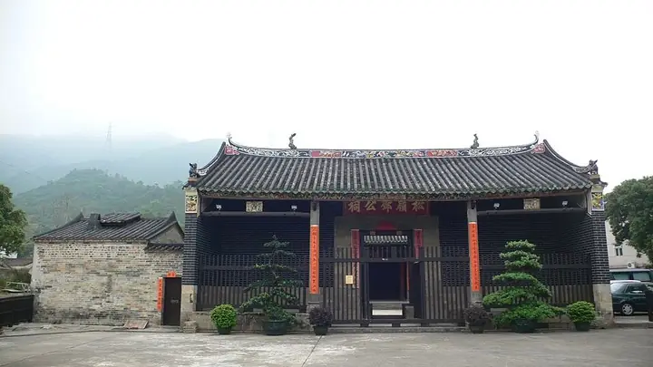 Tang Chung Ling Ancestral Hall on Lung Yeuk Tau Heritage Trail · 龙跃头文物径松岭邓公祠 Photograph date recorded by the source: 05/04/2007 (uploaded on 29/04/2007).
Lung Yeuk Tau Heritage Trail龙跃头文物径
The Lung Yeuk Tau Heritage Trail links ancestral halls, temples and walled-village structures in the Fanling countryside. Tang Chung Ling Ancestral Hall has a three-hall arrangement with carved timber, painted decoration and…
Read the place guide → AI illustration · AI 示意图(仅供参考,非该地点实拍)
Sha Tau Kok Visitor Area沙头角合法开放游览区
Sha Tau Kok is a border town in Hong Kong’s northeastern New Territories, with a compact street district and a pier serving nearby coastal communities.
Read the place guide →Tang Chung Ling Ancestral Hall on Lung Yeuk Tau Heritage Trail in Fanling · 粉岭龙跃头文物径松岭邓公祠. Source-recorded photograph date: 05/04/2007 (uploaded on 29/04/2007).Lung Yeuk Tau Heritage Trail in Fanling粉岭龙跃头文物径
Lung Yeuk Tau Heritage Trail links historic village buildings northeast of Luen Wo Hui in Fanling.
Read the place guide →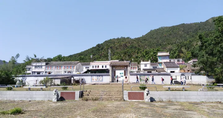 The entrance gate and village houses of Lai Chi Wo Hakka village, North District · 北区荔枝窝客家村入口及村屋 Source-recorded photograph date: 2018-10-28 10:49:13.
Lai Chi Wo Hakka Village荔枝窝
Lai Chi Wo is a Hakka village on the northeastern coast of the New Territories, within the landscape of Hong Kong UNESCO Global Geopark.
Read the place guide →Plan your visit
Getting there
North District is about 20 km in a straight line from central Hong Kong. Search for 北區 in a map app to find stations and your accommodation.
Where to stay →Build your route
Lung Yeuk Tau Heritage Trail and Sha Tau Kok Visitor Area are both listed here. The linked place guides have entrance and visit details.
Continue with Hong Kong →More in Hong Kong
Sources & geographic information
Administrative names and parent areas: Official geographic directory · Reference date 2026-09-06.
Some facts checked against 北區 (香港) — Wikipedia contributors, CC BY-SA 4.0.
Some facts checked against North District, Hong Kong — Wikipedia contributors, CC BY-SA 4.0.
Photo: Lung Yeuk Tau Heritage Trail · Isaac Wong (惡德神父) (Father Vice (惡德神父)) · Isaac Wong (惡德神父) (Father Vice (惡德神父)) — Tang_Chung_Ling_Ancestral_Hall.JPG — CC BY-SA 3.0 · CC BY-SA 3.0. The exact downloaded source bytes are separately retained and hashed. Prepared JPEG is proportionally reduced to a maximum 720-pixel long edge; full frame retained, no subject alteration. Final website rendition: full frame retained, proportionally resized to at most 720 pixels and converted to WebP. No additional retouching or subject alteration. Card displays may crop the view.

Photo: Lung Yeuk Tau Heritage Trail in Fanling · Isaac Wong (惡德神父) (Father Vice (惡德神父)) · CC BY-SA 3.0. Full source framing retained; proportionally resized and converted to WebP. No retouching or subject alteration. Card displays may crop the view.
Photo: Lai Chi Wo Hakka Village · tak.wing · CC BY-SA 2.0. Full frame retained; proportionally resized and converted to WebP. No retouching or changes to the photographed subject. Card displays may crop the view.

Map data © OpenStreetMap contributors. Pins mark approximate centres, not entrances or boundaries.