


Get to know Beichen District

Photo adjustments
Full frame retained; proportionally resized and converted to WebP. No retouching or changes to the photographed subject. Card displays may crop the view.
- Administrative area
- District · 市辖区
- Part of
- Tianjin
- Chinese name
- 北辰区
- Local areas
- District guide
Paths among rivers and embankments
The country park is arranged around two rivers and three embankments. Its cherry garden and Qixing Island (七星岛) children’s play area are connected through a network of cycling paths, fitness trails and greenways. Wanyuan Longshun Manor (万源龙顺度假庄园) draws on the North Canal setting, with bridges over the water and Chinese courtyards in Ming and Qing styles.
Painted streets and fruit-growing villages
The Xiaowubao Rural Complex (小五堡田园综合体) occupies five villages in western Shuangkou Town (双口镇). Its streets combine Beichen farmer-painting imagery with Hui-style architecture, the Guanlin Wrestling Hall (冠林摔跤馆) and an old-style theatre stage. Qianbao Village (前堡村) grows grapes and apples, while Xubao Village (徐堡村) offers jujube picking within the complex.
Sources for this guide
天津 · Ministry of Culture and Tourism
Original English written from the listed sources and checked sentence by sentence against quoted extracts by a separate reviewer. Updated 2026-09-27.
Explore Beichen District
Core places to explore, with English and Chinese names.
Places to explore around Beichen District
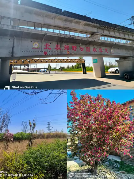 Beichen Country Park ·
 Plan your visit
Getting there
Beichen District is about 10 km in a straight line from central Tianjin. Search for 北辰区 in a map app to find stations and your accommodation.
Where to stay →Build your route
Start with Beichen Country Park. The linked place guides have entrance and visit details.
Continue with Tianjin →More in Tianjin
Sources & geographic information
Administrative names and parent areas: Official geographic directory · Reference date 2026-09-06.
Photo: Beichen Country Park · Source photographer · License not provided. EXIF orientation normalized; resized without changing aspect ratio; converted to WebP. No subject edits.
Map data © OpenStreetMap contributors. Pins mark approximate centres, not entrances or boundaries.