


Get to know Heping District
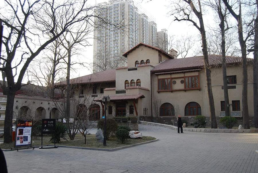
Photo adjustments
Proportionally resized and converted to WebP without cropping, retouching or changing the photographed subject.
- Administrative area
- District · 市辖区
- Part of
- Tianjin
- Chinese name
- 和平区
- Local areas
- District guide
Area & population
- Area in the source
- 9.97 km²
- Population · 2020
- 449,100
Source: cited geographic source, as of the dates shown.
Setting and landscape
The ground is level plain between 2.8 and 4.5 metres above sea level. Across the Hai River to the north-east lie Hebei (河北区) and Hedong (河东区) districts; Nankai (南开区) adjoins it to the west, and to the south roads including Machang Road (马场道) form the boundary with Hexi (河西区).
History
Under the Convention of Peking of 1860, British, American and French concessions were laid out here, followed by a Japanese concession in 1896; the American concession passed to the British in 1902. In the 1920s the French concession gained the Quanyechang (劝业场) department store, the Bohai Building (渤海大楼) and the Wanguo Bridge (万国桥), and became the city's main shopping quarter. The First District took the name Heping on 1 January 1956, after Heping Road (和平路), one of the busiest streets of early modern Tianjin, made up of former streets of the French and Japanese concessions. In 1970 the bed of the Qiangzi River (墙子河) was paved as today's Nanjing Road (南京路) with a railway tunnel beneath it; this line opened as a metro in 1979, making Tianjin the second mainland Chinese city with a metro.
What to see
The district government says 42 percent of Heping's area is historic district, with 44 sites under national protection and two 4A scenic areas: the Five Great Avenues (五大道) and the Jinjie (金街) shopping streets. The Five Great Avenues keep 436 historic Western-style houses and 347 protected sites, and the National Cultural Heritage Administration has named the area a Famous Historic and Cultural Street of China. Former residences there include those of Gu Weijun (顾维钧) and Zhang Zizhong (张自忠), as well as the Qingwang Mansion (庆王府).
Jiefang North Road (解放北路) was once called the "Wall Street of the East": China's first stock exchange opened there and the Large Dragon (大龙邮票), China's first set of postage stamps, was issued there. Other buildings from the concession era include the Astor Hotel (利顺德饭店), Xikai Church (西开教堂), Jing Garden (静园) and Minyuan Square (民园广场), rebuilt from the Minyuan Stadium of 1926. Central Park (中心公园) is among Tianjin's earliest modern parks, and a memorial square recalls the 1976 Tangshan earthquake, which struck Tianjin severely.
Food and local products
The district government counts 25 China Time-honoured Brands here, among them Quanyechang and Goubuli (狗不理). Binjiang Road (滨江道) and Heping Road form the Jinjie shopping area, and the Nanshi (南市) quarter has the Nanshi Food Street (南市食品街).
Highlights
- Five Great Avenues 五大道: 4A area with 436 historic Western-style houses and 347 protected sites.
- Jiefang North Road 解放北路: Site of China's first stock exchange; the Large Dragon stamps were issued here.
- Jinjie 金街: 4A shopping area on Binjiang Road and Heping Road.
- Minyuan Square 民园广场: Open square rebuilt from the Minyuan Stadium, completed in 1926.
- Central Park 中心公园: One of the earliest modern city parks in Tianjin.
Sources for this guide
和平概况_天津市和平区人民政府 · Heping District People's Government, Tianjin
和平区 (天津市) - 维基百科,自由的百科全书 · Chinese Wikipedia · CC BY-SA 4.0
Original English written from the listed sources and checked sentence by sentence against quoted extracts by a separate reviewer. Updated 2026-09-25.
Explore Heping District
Core places to explore, with English and Chinese names.
Places to explore around Heping District
 The Tianjin Eye and Hai River against central Tianjin's skyline.
Tianjin centre天津市中心
Central Tianjin is easiest to understand from the Haihe, where bridges connect the railway-station side with former concession streets and newer waterfront squares. Jiefang Bridge and Jinwan Plaza make a compact introduction to…
Read the place guide → Five Great Avenues · 五大道
Five Great Avenues五大道
The Five Great Avenues are a residential district of former concession-era villas, not five grand monuments. Chongqing, Changde, Dali, Munan and Machang roads carry a mixture of European architectural influences, with…
Read the place guide → St. Joseph Cathedral (Xikai Cathedral), Tianjin.
St. Joseph Cathedral (Tianjin)西开教堂
St. Joseph Cathedral, usually called Xikai Church, stands at the southern end of Tianjin's Binjiang Dao shopping area. Completed in 1916, it provides a conspicuous religious landmark within the former French concession. Red and…
Read the place guide → Porcelain House · 瓷房子
Porcelain House瓷房子
Porcelain House transforms a former European-style residence into an exuberant display of collected ceramics. Owner Zhang Lianzhi covered the building with porcelain fragments and objects, turning walls and roof ornament into a…
Read the place guide →The former residence building and courtyard at Jing Garden in Tianjin.Jing Garden静园
Jing Garden, or the Garden of Serenity, was a private residence before Puyi, the last Qing emperor, moved here in 1929. The house combines a Spanish-influenced main building with other architectural details and a compact…
Read the place guide → The redeveloped Minyuan Stadium courtyard and arcades in Tianjin, August 2018.
Minyuan Stadium民园体育场
Minyuan began as a sports ground in Tianjin's former British concession and later became a familiar football venue. Its association with Olympic runner and missionary Eric Liddell connects the site with the city's international…
Read the place guide → The columned facade and lawn of Qingwang Mansion in Tianjin. Photographed on 21 January 2014.
Qingwang Mansion庆王府
Qingwang Mansion combines an enclosed villa plan with decorative elements drawn from Chinese courtly architecture. Built first for the former court eunuch Zhang Lande and later acquired by Prince Qing's son Zaizhen, it centers…
Read the place guide →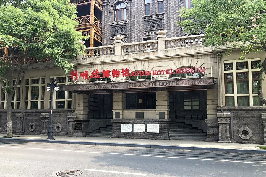 The signed entrance to the Astor Hotel Museum in Tianjin. Photographed on 15 May 2020.
Astor Hotel Heritage Museum利顺德博物馆
The Astor Hotel's museum turns a working historic hotel into a window on Tianjin's treaty-port society. Portraits, documents and objects recall its guests and diplomatic role, while items associated with early electric lighting…
Read the place guide → Jinwan Plaza across the Hai River, seen from the Tianjin Railway Station side. Photographed on 14 April 2016.
Jinwan Plaza津湾广场
Jinwan Plaza occupies a bend on the south bank of the Haihe, directly facing Tianjin Railway Station. Its European-influenced commercial buildings and open riverside platforms form a modern waterfront ensemble on land once…
Read the place guide →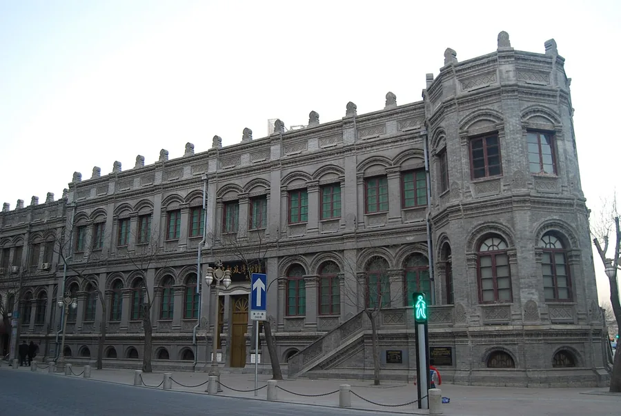 The historic Qing postal administration building that houses Tianjin Postal Museum, viewed from the street. Photographed on 20 December 2010.
Tianjin Postal Museum天津邮政博物馆
Tianjin Postal Museum occupies former Qing postal premises and follows communication from older relay systems to modern mail and stamp collecting. Large Dragon stamp designs and proofs are a central thread, supported by original…
Read the place guide → AI illustration · AI 示意图(仅供参考,非该地点实拍)
Riverside 66恒隆广场
Riverside 66 is a shopping complex whose architecture is as distinctive as its retail use. KPF designed a long, curving glass-and-concrete shell that rises from the river-facing side towards Heping District. Tall concrete ribs…
Read the place guide → A wide city view across the Hai River: the European-style 津湾广场 complex with its red mansard roofs and a tall twin-towered block at the left, a riverfront avenue with street lamps, and a skyline of towers — including a spire-topped high-rise and a tall cylindrical tower — under a blue sky with cloud.
Jinwan Plaza and Jiefang Bridge津湾广场与解放桥
Jinwan Plaza and Jiefang Bridge form a compact Haihe waterfront stop opposite Tianjin’s main railway station.
Read the place guide →Plan your visit
Getting there
Heping District covers the centre of Tianjin. Search for 和平区 in a map app to find stations and your accommodation.
Where to stay →Build your route
Tianjin centre and Five Great Avenues are about 3 km apart in a straight line. The linked place guides have entrance and visit details.
Continue with Tianjin →More in Tianjin
Sources & geographic information
Administrative names and parent areas: Official geographic directory · Reference date 2026-09-06.
Some facts checked against 和平区 (天津市) — Wikipedia contributors, CC BY-SA 4.0.
Photo: Tianjin centre · KangTyngrwey · CC BY-SA 4.0. Proportionally resized and converted to WebP without cropping, retouching or changing the photographed subject.

Photo: Five Great Avenues · xiquinhosilva · CC BY 2.0. Wikimedia thumbnail; fitted to the ranking-card frame.
.jpg)
Photo: St. Joseph Cathedral (Tianjin) · Fanghong · CC BY 2.5. Proportionally resized and converted to WebP without cropping, retouching or changing the photographed subject.

Photo: Porcelain House · xiquinhosilva · CC BY 2.0. Wikimedia thumbnail; fitted to the ranking-card frame.
.jpg)
Photo: Jing Garden · TJArchi-Studio · CC BY-SA 2.0. Proportionally resized and converted to WebP without cropping, retouching or changing the photographed subject.

Photo: Minyuan Stadium · xiquinhosilva · CC BY 2.0. Proportionally resized and converted to WebP without cropping, retouching or changing the photographed subject.
.jpg)
Photo: Qingwang Mansion · Xrdtj · CC BY-SA 3.0. Proportionally resized and converted to WebP without cropping, retouching or changing the photographed subject.

Photo: Astor Hotel Heritage Museum · N509FZ · CC BY-SA 4.0. Proportionally resized and converted to WebP without cropping, retouching or changing the photographed subject.
.jpg)
Photo: Jinwan Plaza · N509FZ · CC BY-SA 4.0. Proportionally resized and converted to WebP without cropping, retouching or changing the photographed subject.
.jpg)
Photo: Tianjin Postal Museum · TJArchi-Studio · CC BY-SA 2.0. Proportionally resized and converted to WebP without cropping, retouching or changing the photographed subject.

Photo: Jinwan Plaza and Jiefang Bridge · KangTyngrwey · CC BY-SA 4.0. Full frame retained; proportionally resized and converted to WebP. No retouching or changes to the photographed subject. Card displays may crop the view.

Map data © OpenStreetMap contributors. Pins mark approximate centres, not entrances or boundaries.