


Get to know Licheng District
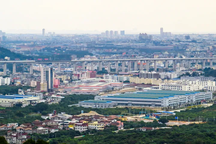
Photo adjustments
Full frame retained; proportionally resized and converted to WebP. No retouching or changes to the photographed subject. Card displays may crop the view.
- Administrative area
- District · 市辖区
- Part of
- Putian
- Chinese name
- 荔城区
- Local areas
- District guide
Area & population
- Area in the source
- 279.00 km²
- Population · 2020
- 673,935
Source: cited geographic source, as of the dates shown.
History
Putian County was set up in 568. In 979 the Northern Song set up the Xinghua military prefecture (兴化军), and from 1369 the Ming Xinghua prefecture (兴化府) governed Putian and Xianyou, the two counties known together as Puxian (莆仙). Its literary name, Puyang (莆阳), reflects the prefecture's position, with Jiuhua Mountain (九华山) behind it and the Mulan River (木兰溪) to the south. Licheng District was created in 2002, when Putian County was abolished.
The Drum Tower (谯楼), on Wenxian Road (文献路), was first built in 983 as the gate tower of the inner city when the military prefecture moved its seat to Putian. After a fire it was rebuilt in 1136 with a drum and water clock, and the present tower dates from a rebuilding of 1697. Putian people treat it as the symbol of Xinghua prefecture.
Setting and landscape
The climate is subtropical maritime monsoon, with a yearly mean of 20.6°C and 1,349 millimetres of rain. The district calls its landscape "lychee groves and water country" (荔林水乡): the Mulan River system here has 497 kilometres of channels. Legend links the river's name to the scholar Zheng Lu (郑露): when he left to take office, people threw magnolia (木兰) flowers onto his boat and the water. In 2017 the Mulan was named one of China's ten most beautiful home rivers. The coastline is 40 kilometres long.
What to see
Three monuments are national key protected sites. The Zhenhai Embankment (镇海堤) runs along the beaches of five villages in Huangshi (黄石镇); it was first raised in the Tang Yuanhe era under the Fujian governor Pei Ciyuan (裴次元), stripped of stone in 1387 by Zhou Dexing (周德兴) to build the walls of the Pinghai garrison, and rebuilt in 1826. The other two are the Northern Song pagoda of Bao'en Temple (报恩寺塔) on Dongyan Hill (东岩山) and Ninghai Bridge (宁海桥) in Qiaodou village. Provincial listings include the Xinghua prefecture City God Temple (兴化府城隍庙), the Dazongbo mansion (大宗伯第) and the Methodist church of 1918 (卫理公会莆田总堂).
The Xinghua prefecture historic block (兴化府历史文化街区) and Putian Arts and Crafts City (莆田工艺美术城) are among the district's A-level scenic areas. In 2007 the Ministry of Culture named Licheng a national home of folk painting and of folk drama.
Highlights
- Zhenhai Embankment 镇海堤: Tang-era sea wall in Huangshi, rebuilt in 1826; national key protected site since 2006.
- Drum Tower 谯楼: Gate tower of Song Putian first built in 983; the present structure dates from 1697.
- Bao'en Temple pagoda 报恩寺塔: Northern Song pagoda on Dongyan Hill; national key protected site.
- Xinghua prefecture City God Temple 兴化府城隍庙: Provincially protected temple in Zhenhai subdistrict (镇海街道).
Sources for this guide
荔城概况 · Licheng District People's Government, Putian
生态资源富集 · Licheng District People's Government, Putian
荔城区 - 维基百科,自由的百科全书 · Wikipedia (Chinese) · CC BY-SA 4.0
荔城区各级文物保护单位列表 - 维基百科,自由的百科全书 · Wikipedia (Chinese) · CC BY-SA 4.0
镇海堤 - 维基百科,自由的百科全书 · Wikipedia (Chinese) · CC BY-SA 4.0
莆田谯楼 - 维基百科,自由的百科全书 · Wikipedia (Chinese) · CC BY-SA 4.0
Original English written from the listed sources and checked sentence by sentence against quoted extracts by a separate reviewer. Updated 2026-09-23.
Explore Licheng District
Core places to explore, with English and Chinese names.
Licheng District 荔城区
Plan your visit
Getting there
Licheng District covers the centre of Putian. Search for 荔城区 in a map app to find stations and your accommodation.
Where to stay →More in Putian
Sources & geographic information
Administrative names and parent areas: Official geographic directory · Reference date 2026-09-06.
Some facts checked against 荔城区 — Wikipedia contributors, CC BY-SA 4.0.
Some facts checked against 荔城区各级文物保护单位列表 — Wikipedia contributors, CC BY-SA 4.0.
Some facts checked against 镇海堤 — Wikipedia contributors, CC BY-SA 4.0.
Some facts checked against 莆田谯楼 — Wikipedia contributors, CC BY-SA 4.0.
Map data © OpenStreetMap contributors. Pins mark approximate centres, not entrances or boundaries.