


Get to know Changtai District
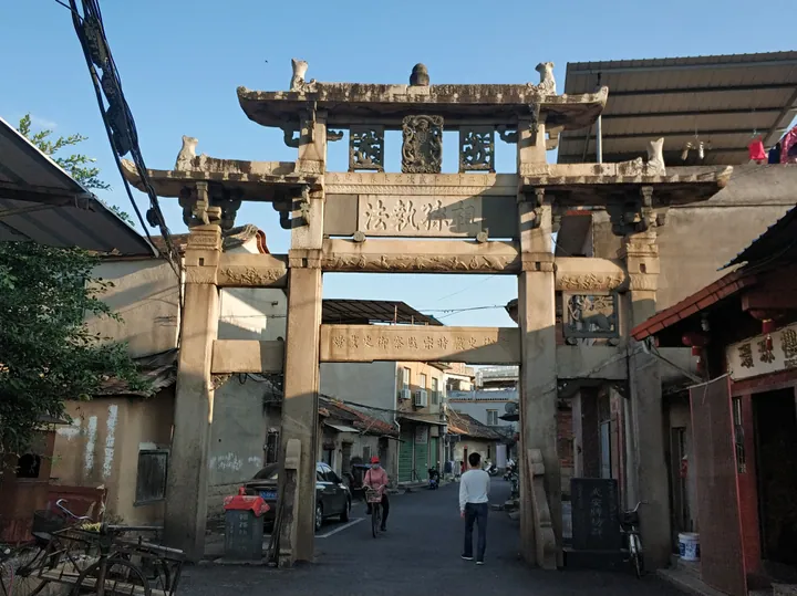
Photo adjustments
Full frame retained; proportionally resized and converted to WebP. No retouching or changes to the photographed subject. Card displays may crop the view.
- Administrative area
- District · 市辖区
- Part of
- Zhangzhou
- Chinese name
- 长泰区
- Local areas
- District guide
Area & population
- Area in the source
- 2,034.00 km²
- Population · 2020
- 228,235
Source: cited geographic source, as of the dates shown.
Setting and landscape
The district government sums up the land as "seven parts hills, one part water, two parts fields" (七山一水二分田). The terrain is shaped like a palm-leaf fan and forms a horseshoe open to the south, falling from a highest peak of 1,128 metres to flats only 7 metres above sea level. The climate is south-subtropical and maritime, with an average annual temperature of 22.9°C and 1,405.8 mm of rain. Forest covers 54.8% of the land, and Changtai was Fujian's first national ecological county.
Its neighbours are Anxi County (安溪县) of Quanzhou to the north, Longhai (龙海) to the south, Hua'an County (华安县) and Longwen District (龙文区) to the west, and Xiamen to the south-east.
History
In the Sui and Tang periods the area was part of Nan'an County (南安县) under Quanzhou. A local administrative post, Wude (武德场), was set up in 876, renamed Wusheng (武胜场) in 888 and later Wu'an (武安场). Changtai became a county in 955 under the Southern Tang, its name meaning "lasting peace", and passed from Quanzhou to Zhangzhou in 980. The county was turned into a district of Zhangzhou on 2 February 2021; the seat is in Wu'an Subdistrict (武安街道).
What to see
The Mayangxi Eco-Tourism Zone (马洋溪生态旅游区) was founded in 2004 in the east of the district next to Xiamen and Quanzhou, where forest covers 78.8% of the land. It contains Shanzhong (山重), a listed Chinese traditional village, and Houfang Village (后坊村), a Fujian historical and cultural village. The Xue family ancestral temple (薛氏家庙) and Zhaoning Temple (昭宁宫) are provincial protected sites, and the zone also has the former home of Zhu Yigui (朱一贵), styled the "Zhongxing King" (中兴王, restoration king) of Taiwan. The zone keeps the provincially listed folk custom of a big-pig contest to pray for a good harvest (赛大猪祈丰年).
Named attractions in the zone include the 4A-rated Shili Lanshan (十里蓝山) and Tianzhushan Happy World (天柱山欢乐大世界), the Longren guqin culture village (龙人古琴文化村) and Changtai rafting. Other scenic spots in the district include Tianzhu Mountain National Forest Park (天柱山国家森林公园), Huopan Lake (活盘湖) and the Baizhangya waterfall (百丈崖瀑布).
Food and local products
The district government calls Changtai the home of Chinese ponkan mandarins (芦柑). Other local produce includes pomelo, longan, lychee, bananas, edible fungi, tea and sharen (砂仁), a cardamom-like medicinal seed.
Getting oriented
The Xiamen–Chengdu (厦蓉) and Ningbo–Dongguan (甬莞) expressways are among those crossing the district, which has four interchanges; the Xiamen–Chengdu Expressway has one at Tianzhushan in the Mayangxi zone. The Yingtan–Xiamen Railway (鹰厦铁路) also passes through.
Highlights
- Mayangxi Eco-Tourism Zone 马洋溪生态旅游区: Tourism zone in the east of the district, founded in 2004, with 78.8% forest cover.
- Shanzhong Village 山重: Listed Chinese traditional village in the Mayangxi zone.
- Houfang Village 后坊村: Fujian historical and cultural village in the Mayangxi zone.
- Tianzhu Mountain National Forest Park 天柱山国家森林公园: Forest park listed among the district's sights.
- Ponkan mandarin 芦柑: Changtai is called the home of Chinese ponkan mandarins.
Sources for this guide
自然资源 · Changtai District People's Government, Zhangzhou
马洋溪生态旅游区 - 乡镇概况 · Changtai District People's Government, Zhangzhou
地理长泰 - 地理环境 · Changtai District People's Government, Zhangzhou
长泰区 - 维基百科,自由的百科全书 · Wikipedia (Chinese) · CC BY-SA 4.0
Original English written from the listed sources and checked sentence by sentence against quoted extracts by a separate reviewer. Updated 2026-09-23.
Explore Changtai District
Core places to explore, with English and Chinese names.
Changtai District 长泰区
Plan your visit
Getting there
Changtai District is about 25 km in a straight line from central Zhangzhou. Search for 长泰区 in a map app to find stations and your accommodation.
Where to stay →More in Zhangzhou
Sources & geographic information
Administrative names and parent areas: Official geographic directory · Reference date 2026-09-06.
Some facts checked against 长泰区 — Wikipedia contributors, CC BY-SA 4.0.
Map data © OpenStreetMap contributors. Pins mark approximate centres, not entrances or boundaries.