


Get to know Dongshan County

Photo adjustments
Resized and WebP compressed; subject not altered.
- Administrative area
- County · 县
- Part of
- Zhangzhou
- Chinese name
- 东山县
- Local areas
- County guide
Area & population
- Area in the source
- 194.00 km²
- Population · 2020
- 219,511
Source: cited geographic source, as of the dates shown.
Setting and landscape
The Taiwan Strait lies to the east and the Chaoshan (潮汕) area of Guangdong lies beyond the sea to the south. Zhao'an Bay (诏安湾) separates Dongshan from Zhao'an County (诏安县) to the west, Dongshan Bay (东山湾) separates it from the Gulei Peninsula (古雷半岛) to the north-east, and across the Bachimen Strait (八尺门海峡) to the north-west is Yunxiao County (云霄县). Of the county's 76 listed islands, only two are inhabited: Dongshan Island itself and Dachan Island (大产岛).
History
In 1387 the Ming set up the Tongshan garrison post (铜山守御千户所) on the island, which then belonged to Zhangpu County (漳浦县); in the Qing the whole island came under Zhao'an. Dongshan County was created in 1916, with its seat at Tongshan city (铜山城), today's Tongling (铜陵). The county government moved to Xipu (西埔) in March 1956, and the Gulei Peninsula, once part of the county, was transferred to Zhangpu in November 1955.
What to see
Tongling, on the island's north-east corner with the sea on three sides, is an old town with more than 600 years of history, long nicknamed "Zou and Lu by the sea" (海滨邹鲁). The Tongshan Guandi Temple (铜山关帝庙) is a national protected site. The Wind-Moving Stone (风动石) scenic area, rated 4A, takes in the Guandi Temple, the old city and the former home of the Ming scholar Huang Daozhou (黄道周); other sights include Koxinga's naval drill platform (郑成功水操台) and cliff inscriptions on Jiuxian Mountain (九仙山). Two crescent bays, Yunan (屿南湾) and Nanmen (南门湾), run together on the town's shore.
Maluan Bay (马銮湾), on the south-west side of the island, is a crescent of about 2,500 metres with a sandy beach about 60 metres wide, and is a national sailing and windsurfing training base. The 2026 summer-climate map by the National Climate Center (国家气候中心) and China Weather (中国天气) listed it as a seaside summer retreat.
Crafts and traditions
Dongshan song-books (东山歌册) were in the first batch of national intangible heritage, and Tongling is also home to Nanyin (南音) and the old eight-instrument ensemble music (古八音). Tongling is also the county's main fishing area.
Highlights
- Wind-Moving Stone scenic area 风动石: 4A scenic area in Tongling taking in the Guandi Temple, the old city and Huang Daozhou's former home.
- Tongshan Guandi Temple 铜山关帝庙: National protected site in the old garrison town of Tongling.
- Maluan Bay 马銮湾: Crescent bay of about 2,500 metres on the south-west of the island; national sailing and windsurfing training base.
- Nanmen Bay 南门湾: Crescent bay on the Tongling shore, joined to Yunan Bay.
- Dongshan song-books 东山歌册: Listed in the first batch of national intangible heritage.
Sources for this guide
位置面积 - 地理环境 · Dongshan County People's Government
建制沿革 · Dongshan County People's Government
铜陵镇概况 - 乡镇概况 · Dongshan County People's Government
漳州东山岛的马銮湾景区入选“海滨避暑”类型推荐 - 东山要闻 · Dongshan County People's Government
Original English written from the listed sources and checked sentence by sentence against quoted extracts by a separate reviewer. Updated 2026-09-25.
Explore Dongshan County
Core places to explore, with English and Chinese names.
Places to explore around Dongshan County
 Panoramic view of Nanmen Bay in Dongshan County, Zhangzhou, with the crescent beach and waterfront town · 漳州市东山县南门湾全景,新月形沙滩与滨海小镇 Source-recorded photograph date: 2018-07-19 07:49:42.
Nanmen Bay南门湾
Nanmen Bay curves below Tongling's hillside fishing-village houses on the southeastern side of the town in Dongshan County.
Read the place guide →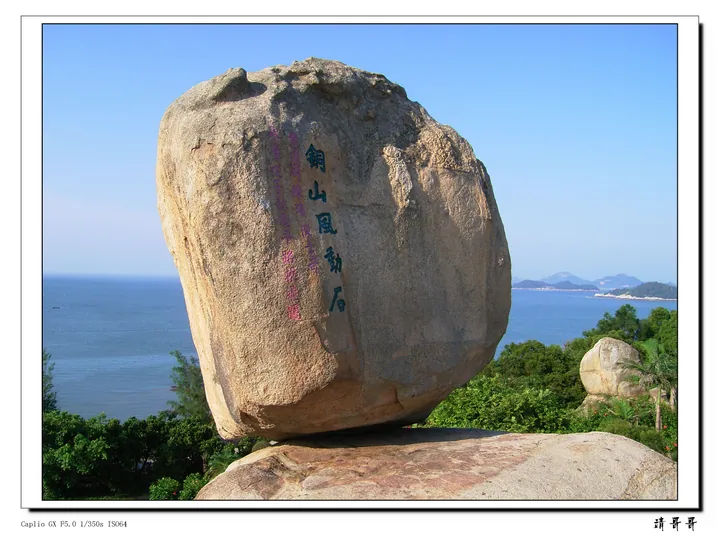 A huge rounded granite boulder balanced on a flat rock ledge, carrying carved characters 銅山風動石 and smaller red inscriptions, with green trees and shrubs around it and blue sea, headlands and distant islands behind; the file has a thin white border with a Caplio GX exposure caption at the lower left and a 請哥哥 watermark at the lower right.
Dongshan Tongling Ancient Town and Wind-Moving Rock铜陵古镇与风动石
Tongling combines the streets of the former Tongshan coastal fortress with the nearby Guandi Temple and Fengdongshi, Dongshan's celebrated balanced boulder.
Read the place guide → The curving sandy shoreline of Maluan Bay on Dongshan Island · 东山岛马銮湾沙滩海岸线 Source-recorded photograph date: 2025-02-08 12:41:45.
Maluan Bay马銮湾
Maluan Bay lies on Dongshan Island's eastern shore, with a pale sandy beach backed by coastal woodland.
Read the place guide →Plan your visit
Getting there
Dongshan County is about 95 km in a straight line from central Zhangzhou. Search for 东山县 in a map app to find stations and your accommodation.
Where to stay →Build your route
Nanmen Bay and Dongshan Tongling Ancient Town and Wind-Moving Rock are both listed here. The linked place guides have entrance and visit details.
Continue with Zhangzhou →More in Zhangzhou
Sources & geographic information
Administrative names and parent areas: Official geographic directory · Reference date 2026-09-06.
Photo: Nanmen Bay · Thyj · CC BY-SA 4.0. Full frame retained; proportionally resized and converted to WebP. No retouching or changes to the photographed subject. Card displays may crop the view.

Photo: Dongshan Tongling Ancient Town and Wind-Moving Rock · gdczjkk · CC BY 3.0. Full frame retained; proportionally resized and converted to WebP. No retouching or changes to the photographed subject. Card displays may crop the view.

Photo: Maluan Bay · H2v5o68z · CC0. Full frame retained; proportionally resized and converted to WebP. No retouching or changes to the photographed subject. Card displays may crop the view.

Map data © OpenStreetMap contributors. Pins mark approximate centres, not entrances or boundaries.