


Get to know Nanjing County

Photo adjustments
Full frame retained; resized proportionally to a maximum dimension of 960 pixels and converted to WebP quality 88. No crop, retouch, generated elements, or subject alteration. Final website rendition: full frame retained, proportionally resized to at most 720 pixels and converted to WebP. No additional retouching or subject alteration. Card displays may crop the view.
- Administrative area
- County · 县
- Part of
- Zhangzhou
- Chinese name
- 南靖县
- Local areas
- County guide
Area & population
- Area in the source
- 227.70 km²
- Population · 2020 census
- 305,259
Source: cited geographic source, as of the dates shown.
History
The county government dates the county to 1322, under the Yuan, and gives Lanshui (兰水县) as its old name. It began as Nansheng County (南胜县); in 1356, after repeated raids left it unsettled, it was renamed Nanjing, a name the county government glosses as "the calm of the south", given as a good omen. The county was part of the Central Soviet Area and a main battlefield of the Central Red Army's Eastern Route Army during its Zhangzhou campaign.
Setting and landscape
The land slopes from north-west to south-east and is made up of three spur ranges, the Boping (博平岭), Chaotian (朝天岭) and Banliao (坂寮岭) ridges. Three rivers, the Chuanchang (船场溪), Longshan (龙山溪) and Yongfeng (永丰溪) streams, run through the county in the pattern of the character chuan (川, "river"), splitting it into eastern, western and central blocks. The highest point, at 1,390.9 metres, is Jiaotangdong (蛟塘岽) in Shuyang town. The climate is south subtropical monsoon, and the county government counts 14 hot springs. Southern Min (Minnan) is the everyday language, while some villages in Shuyang and Meilin speak Hakka.
What to see
Shuyang town (书洋镇), where Nanjing meets Pinghe and Yongding counties, is the approach to the 5A-rated tulou scenic areas of Yunshuiyao and Tianluokeng. The county government counts more than 15,000 surviving earthen buildings, and Tianluokeng is on the first national list of historic and cultural villages. Its cluster sets a square Buyun building (步云楼), first built in 1796, among three round buildings and one oval one, a layout nicknamed "four dishes and a soup". The Nanjing tulou inscribed by UNESCO in 2008 also include the Hekeng cluster (河坑土楼群), Hegui Lou (和贵楼) and Huaiyuan Lou (怀远楼). Yuchang Lou (裕昌楼), a five-storey round building in Shuyang, is dated to 1308. The county also holds the Hubeiliao (虎伯寮) national nature reserve.
Food and local products
Nanjing carries five national "home of" titles, for orchids, jinxianlian (金线莲, a jewel orchid), bananas, ma bamboo and ponkan mandarins. Shuyang town accounts for half of the county's tea acreage, with Dangui (丹桂), Tieguanyin (铁观音), Qilan (奇兰) and Maoxie (毛蟹) as its main varieties.
Highlights
- Tianluokeng Tulou Cluster 田螺坑土楼群: Square Buyun building of 1796 ringed by three round buildings and an oval one, the "four dishes and a soup" layout.
- Yunshuiyao 云水谣: 5A-rated tulou scenic area reached through Shuyang town.
- Hekeng Tulou Cluster 河坑土楼群: Shuyang cluster included in the 2008 UNESCO inscription of the Fujian tulou.
- Yuchang Lou 裕昌楼: Five-storey round tulou in Shuyang dated to 1308.
- Hubeiliao National Nature Reserve 虎伯寮国家级自然保护区: National-level nature reserve within the county.
Sources for this guide
南靖概况 · Nanjing County People's Government
地理环境 · Nanjing County People's Government
书洋镇概况 · Nanjing County People's Government
Fujian tulou · Wikipedia (English) · CC BY-SA 4.0
Original English written from the listed sources and checked sentence by sentence against quoted extracts by a separate reviewer. Updated 2026-09-25.
Explore Nanjing County
Core places to explore, with English and Chinese names.
Places to explore around Nanjing County
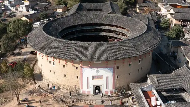 Nanjing Yunshuiyao Tulou Area · 南靖云水谣土楼景区
Nanjing Yunshuiyao Tulou Area南靖云水谣土楼景区
Yunshuiyao combines a village walking route with the Hegui and Huaiyuan tulou in Nanjing County.
Read the place guide →Yunshuiyao Village with Hegui and Huaiyuan Tulou · 云水谣与和贵楼怀远楼Yunshuiyao Village with Hegui and Huaiyuan Tulou云水谣与和贵楼怀远楼
Yunshuiyao in Nanjing County connects a riverside village landscape with two distinct earthen residences: rectangular Hegui Lou and circular Huaiyuan Lou.
Read the place guide → Aerial view of the round earthen tulou buildings of He Keng Tu Lou Qun (Hekeng Tulou Cluster) in Nanjing County, Zhangzhou · 漳州市南靖县河坑土楼群航拍 Source-recorded photograph date: Taken on 2 May 2012.
Hekeng Tulou Cluster河坑土楼群
Hekeng is a cluster of earthen communal houses in Qujiang village, where buildings follow a narrow valley toward the stream in Nanjing County.
Read the place guide →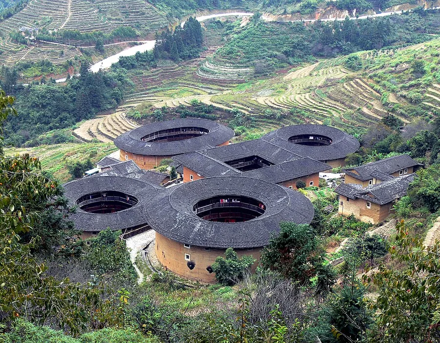 Tianluokeng Tulou Cluster, Nanjing County, Fujian.
Tianluokeng Tulou Cluster田螺坑土楼群
Tianluokeng gathers five earthen residences into a compact hillside composition: a square building at the centre, with round and oval neighbours around it. The central Buyun building anchors the arrangement, while the…
Read the place guide →Plan your visit
Getting there
Nanjing County is about 30 km in a straight line from central Zhangzhou. Search for 南靖县 in a map app to find stations and your accommodation.
Where to stay →Build your route
Nanjing Yunshuiyao Tulou Area and Yunshuiyao Village with Hegui and Huaiyuan Tulou are both listed here. The linked place guides have entrance and visit details.
Continue with Zhangzhou →More in Zhangzhou
Sources & geographic information
Administrative names and parent areas: Official geographic directory · Reference date 2026-09-06.
Some facts checked against Fujian tulou — Wikipedia contributors, CC BY-SA 4.0.
Photo: Nanjing Yunshuiyao Tulou Area · Source photographer · License not provided. EXIF orientation normalized; resized without changing aspect ratio; converted to WebP. No subject edits.
Photo: Yunshuiyao Village with Hegui and Huaiyuan Tulou · Source photographer · License not provided. EXIF orientation normalized; resized without changing aspect ratio; converted to WebP. No subject edits.
Photo: Hekeng Tulou Cluster · 张元柏 · CC BY-SA 3.0. Full frame retained; proportionally resized and converted to WebP. No retouching or changes to the photographed subject. Card displays may crop the view.
.jpg)
Photo: Tianluokeng Tulou Cluster · Gisling · CC BY-SA 3.0. Proportionally resized and converted to WebP without cropping, retouching or changing the photographed subject.

Map data © OpenStreetMap contributors. Pins mark approximate centres, not entrances or boundaries.