


Get to know Lintao County
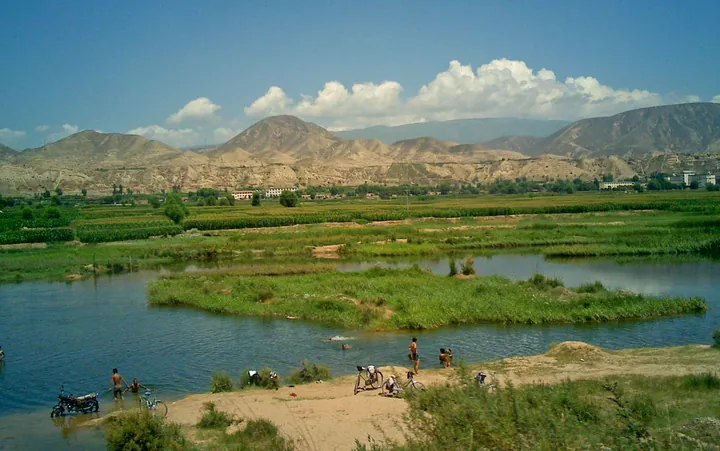
Photo adjustments
Full frame retained; proportionally resized and converted to WebP. No retouching or changes to the photographed subject. Card displays may crop the view.
- Administrative area
- County · 县
- Part of
- Dingxi
- Chinese name
- 临洮县
- Local areas
- County guide
Area & population
- Area in the source
- 2,851.00 km²
- Population · 2019
- 554,900
- Administrative seat
- Taoyang
Source: cited geographic source, as of the dates shown.
Setting and landscape
The county is a long strip, 103 km from north to south and 78 km across, with the land falling from south-east to north-west. The Tao River, which the county describes as the largest tributary of the upper Yellow River, flows 115 km through nine of its townships, and its valley floor is flat and unbroken. Heights range from 1,730 to 3,670 metres. In deep winter the Tao carries strings of round ice beads, a sight known as the "Tao River pearls" (洮水流珠).
History
Lintao was anciently called Didao (狄道). The Qin set up Didao County in 384 BC, and in 280 BC made it the seat of Longxi Commandery (陇西郡). The Tibetans took Didao in 762; after 1071 the Northern Song made it Xizhou (熙州). The Jin, Yuan, Ming and Qing all based Lintao Prefecture (临洮府) here until the Qing moved the prefecture seat to Lanzhou in 1740. Didao became a county again in 1913 and was renamed Lintao in 1929.
In July 1924 the Swedish archaeologist Andersson (安特生) found painted pottery at Majiayao village, about 10 km south-west of the county seat on the west bank of the Tao. The archaeologist Xia Nai (夏鼐) proposed in 1949 that these remains be named the Majiayao culture after this site. The Xindian (辛店) and Siwa (寺洼) cultures are also named after finds in the county.
What to see
The Majiayao site was listed as a national key cultural relic protection unit on 13 January 1988. The county has three 4A scenic areas: Yuelu Mountain (岳麓山), Nanping Mountain (南屏山) and the Tao River stone culture park (洮河石文化博览园). It presents itself as the western starting point of the Warring States Qin Great Wall, and its historic sites include the Tang-dynasty stele recording the deeds of Geshu Han (哥舒翰). The county also has the Tao River National Wetland Park (洮河国家湿地公园).
Food and local products
Local snacks include Lintao niangpi (临洮酿皮), hot-and-cold noodles (热凉面), stone-baked bread (石子馍) and potato jiaotuan (洋芋搅团). Local products include ruan'er pears (软儿梨), lilies and crisp candy (酥糖), and the county's fields are planted with potatoes, vegetables, medicinal herbs, lilies and flowers.
Highlights
- Majiayao site 马家窑遗址: Type site of the Majiayao culture, found in 1924 and a national protected site since 1988.
- Yuelu Mountain 岳麓山: A 4A scenic area, listed first among the county's three.
- Tao River pearls 洮水流珠: Round ice beads that float down the Tao in deep winter.
- Lintao niangpi 临洮酿皮: Listed among Lintao's local snacks.
Sources for this guide
临洮县人民政府 临洮概况 · Lintao County People's Government
临洮县人民政府 历史沿革 · Lintao County People's Government
临洮县人民政府 地理交通 · Lintao County People's Government
马家窑文化——黄河上游史前文化的代表 · Lintao County People's Government
洮水流珠的传说 · Lintao County People's Government
临洮县 - 维基百科,自由的百科全书 · Chinese Wikipedia · CC BY-SA 4.0
Original English written from the listed sources and checked sentence by sentence against quoted extracts by a separate reviewer. Updated 2026-09-23.
Explore Lintao County
Core places to explore, with English and Chinese names.
Lintao County 临洮县
Plan your visit
Getting there
Lintao County is about 70 km in a straight line from central Dingxi. Search for 临洮县 in a map app to find stations and your accommodation.
Where to stay →More in Dingxi
Sources & geographic information
Administrative names and parent areas: Official geographic directory · Reference date 2026-09-06.
Some facts checked against 临洮县 — Wikipedia contributors, CC BY-SA 4.0.
Map data © OpenStreetMap contributors. Pins mark approximate centres, not entrances or boundaries.