


Get to know Min County
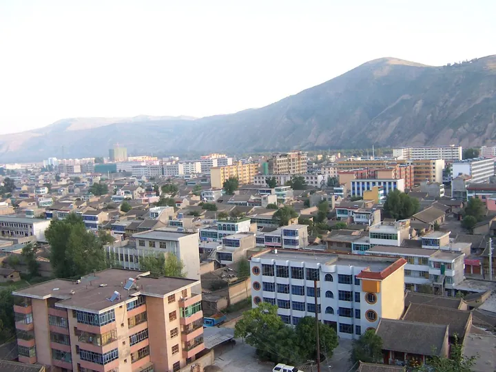
Photo adjustments
Full frame retained; proportionally resized and converted to WebP. No retouching or changes to the photographed subject. Card displays may crop the view.
- Administrative area
- County · 县
- Part of
- Dingxi
- Chinese name
- 岷县
- Local areas
- County guide
Area & population
- Area in the source
- 3,578.00 km²
- Administrative seat
- Minyang
Source: cited geographic source, as of the dates shown.
Setting and landscape
Most of the county lies between 2,300 and 3,000 metres. The west and north are wide valleys of the middle Tao, whose broad river terraces hold the best farmland, while the east is a set of upland basins draining partly to the Wei River and partly to the Yangtze. The southern mountains form the divide between the Yellow River and Yangtze basins. The climate is cold and humid, with an average of 5.5°C and about 635 mm of rain a year.
History
Under the Qin the area was Lintao County (临洮县), and the county claims the western end of the Qin Great Wall; remains of that wall survive on Erlang Mountain (二郎山) in the county town. Minzhou was set up under the Western Wei, and its name, taken from the Min Mountains (岷山), was settled from 618. The Ming placed the Minzhou Guard (岷州卫) here in 1378, and the name Min County dates from 1913.
In 1935 and 1936 units of the Red Army's First, Second and Fourth Front Armies stopped in the county for 61 days. The Communist Party's Northwest Bureau held the Minzhou conference here, and Gansu's first soviet government was set up in the county.
What to see
Six Neolithic sites here belong to the Majiayao (马家窑), Siwa (寺洼) and Qijia (齐家) cultures. Later relics include the site of a Song mint at Taoshan (滔山铸钱监遗址) and the Zhenwu Temple (真武庙), a Ming building in the town that is still intact. Scenic areas include Erlang Mountain Forest Park (二郎山森林公园) and the Langdu grassland wetland (狼渡草原湿地). Taomin hua'er (洮岷花儿) singing is held with temple fairs around the Dragon Boat Festival; the county government says it is on the world intangible-heritage list, and the Badang dance (巴当舞) and the Qingmiao festival (青苗会) are national intangible heritage.
Food and local products
Min County calls itself "China's home of angelica"; angelica (当归) has been grown here for more than 1,400 years, and the county's angelica-growing system is listed as an important agricultural heritage of China. Tao inkstones (洮砚) from Min County are counted among China's famous inkstones. Juema pigs (蕨麻猪) are raised loose on the grasslands, where they feed largely on silverweed. Roasted broad beans are eaten on the second day of the second lunar month, and Minxian pastries (岷县点心) are a baked local speciality.
Highlights
- Erlang Mountain 二郎山: Hill in the county town with remains of the Qin Great Wall and a forest park.
- Zhenwu Temple 真武庙: Ming-dynasty temple in the county town, preserved intact.
- Langdu grassland wetland 狼渡草原湿地: Grassland and wetland scenic area; "Langdu pastures" is one of the Eight Views of Minzhou.
- Taomin hua'er 洮岷花儿: Folk-song tradition, sung at temple fairs around the Dragon Boat Festival.
- Min County angelica 岷县当归: Grown here for more than 1,400 years.
- Tao inkstone 洮砚: Inkstone made in Min County; its making is national intangible heritage.
Sources for this guide
岷县人民政府 岷县概况 · Min County People's Government
岷县 - 维基百科,自由的百科全书 · Chinese Wikipedia · CC BY-SA 4.0
定西市人民政府 定西简介 · Dingxi Municipal People's Government
Original English written from the listed sources and checked sentence by sentence against quoted extracts by a separate reviewer. Updated 2026-09-23.
Explore Min County
Core places to explore, with English and Chinese names.
Places to explore around Min County
 AI illustration · AI
 Plan your visit
Getting there
Min County is about 140 km in a straight line from central Dingxi. Search for 岷县 in a map app to find stations and your accommodation.
Where to stay →Build your route
Start with Langdu Wetland Grassland. The linked place guides have entrance and visit details.
Continue with Dingxi →More in Dingxi
Sources & geographic information
Administrative names and parent areas: Official geographic directory · Reference date 2026-09-06.
Some facts checked against 岷县 — Wikipedia contributors, CC BY-SA 4.0.
Map data © OpenStreetMap contributors. Pins mark approximate centres, not entrances or boundaries.