


Get to know Zhang County

- Administrative area
- County · 县
- Part of
- Dingxi
- Chinese name
- 漳县
- Local areas
- County guide
Area & population
- Population · 2017
- 198,200
- Administrative seat
- Wuyang
Source: cited geographic source, as of the dates shown.
Setting and landscape
Altitudes range from 1,640 to 3,941 metres, and the ground is higher in the west than in the east. The northeast is gullied loess hill country, while the southwest is stony mountain terrain of the western Qinling. Three main rivers cross the county, the Zhang (漳河), the Bangsha (榜沙河) and the Longchuan (龙川河), all part of the Wei River system. Lugu Mountain (露骨山) keeps snow all year.
History
Under the Eastern Zhou, the state of Qin set up the Yanchuan stockade (盐川寨) at Yanjing (盐井, "salt well"). A county was founded in AD 76, under Emperor Zhang of the Eastern Han, and called Zhang (障, "barrier") because it was seen as the Han empire's western shield. Empress Wu renamed it Wuyang (武阳县), and in the Hongwu years of the Ming it took its present name, explained by the Zhang River watering the land and its "precious wells" (宝井) serving the people and the state.
The county was merged into Longxi (陇西) in 1829 and restored in 1913, then absorbed into Wushan County (武山县) in April 1958 and restored in December 1961.
What to see
Zheyang Mountain (遮阳山), named because the rising sun is hidden behind it, serves as a training base for China's national rock-climbing team; the city government describes its sinkholes and slot-like gorges as rare in northern China. Guiqing Mountain (贵清山) and Zheyang together form a national forest park, whose protected animals include leopards, bears, serows and golden pheasants. The county also has a national nature reserve for rare aquatic animals such as the Qinling lenok (秦岭细鳞鲑) and the otter.
The Wang family cemetery (汪氏家族墓地), with burials from the Yuan into the Ming, was listed as a national key protected site on 25 June 2001. The city government calls it the most complete and largest Yuan tomb group of its period in China. Other sites include the Danxia landforms of Hanjiagou (韩家沟) and the site of the Yanjing Meeting (盐井会议) of the Northwest Bureau, held when the Red Army's Long March passed through the county.
Food and local products
Zhang salt (漳盐) is treated as the county's founding tradition and carries the title "the first salt well of the northwest" (西北盐业第一井). Rock salt and andalusite are among the minerals the county has worked.
Getting oriented
Zhang County lies between Lanzhou (兰州) and Tianshui (天水), bordering Wushan to the east, Zhuoni County (卓尼县) to the west, Min County (岷县) to the south, and Longxi and Weiyuan (渭源县) to the north. The Lanzhou–Chongqing railway stops at a station here.
Highlights
- Zheyang Mountain 遮阳山: Training base of the national rock-climbing team, with sinkholes and slot-like gorges.
- Guiqing Mountain 贵清山: Forms a national forest park together with Zheyang Mountain.
- Wang family cemetery 汪氏家族墓地: Yuan-to-Ming family tombs, a national key protected site since 2001.
- Zhang salt 漳盐: Salt tradition handed down for a thousand years and known as the first salt well of the northwest.
Sources for this guide
定西市人民政府 县区概况 漳县 · Dingxi Municipal People's Government
漳县 - 维基百科,自由的百科全书 · Wikipedia (Chinese) · CC BY-SA 4.0
汪氏家族墓地 - 维基百科,自由的百科全书 · Wikipedia (Chinese) · CC BY-SA 4.0
Original English written from the listed sources and checked sentence by sentence against quoted extracts by a separate reviewer. Updated 2026-09-23.
Explore Zhang County
Core places to explore, with English and Chinese names.
Places to explore around Zhang County
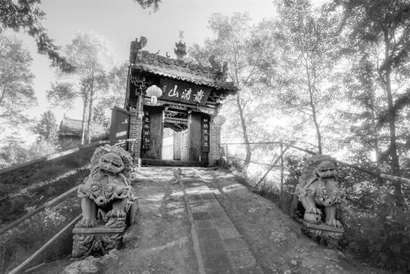 Guiqing Mountain · 贵清山
Guiqing Mountain贵清山
Guiqing Mountain (贵清山) is a forested mountain and gorge in Caotan township, 72 km south of the Zhangxian county seat in Dingxi, Gansu, known as the 小华山 of Longzhong and rated a 4A scenic area in the provincial register.
Read the place guide →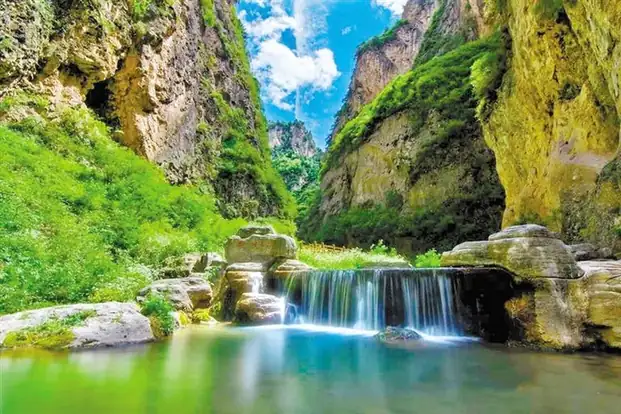 Zheyang Mountain · 遮阳山
Zheyang Mountain遮阳山
Zheyang Mountain (遮阳山) is a national forest park and 4A-rated scenic area in Dacaotan township, Zhangxian County, Dingxi, Gansu, named for being screened from the sun at sunrise and known for the sinkhole and fissure karst the Lanzhou Morning Post calls rare in the north-west.
Read the place guide →Plan your visit
Getting there
Zhang County is about 85 km in a straight line from central Dingxi. Search for 漳县 in a map app to find stations and your accommodation.
Where to stay →Build your route
Guiqing Mountain and Zheyang Mountain are both listed here. The linked place guides have entrance and visit details.
Continue with Dingxi →More in Dingxi
Sources & geographic information
Administrative names and parent areas: Official geographic directory · Reference date 2026-09-06.
Some facts checked against 漳县 — Wikipedia contributors, CC BY-SA 4.0.
Some facts checked against 汪氏家族墓地 — Wikipedia contributors, CC BY-SA 4.0.
Photo: Guiqing Mountain · Source photographer · License not provided. EXIF orientation normalized; resized without changing aspect ratio; converted to WebP. No subject edits.
Photo: Zheyang Mountain · Source photographer · License not provided. EXIF orientation normalized; resized without changing aspect ratio; converted to WebP. No subject edits.
Map data © OpenStreetMap contributors. Pins mark approximate centres, not entrances or boundaries.