


Get to know Zhangjiachuan Hui Autonomous County
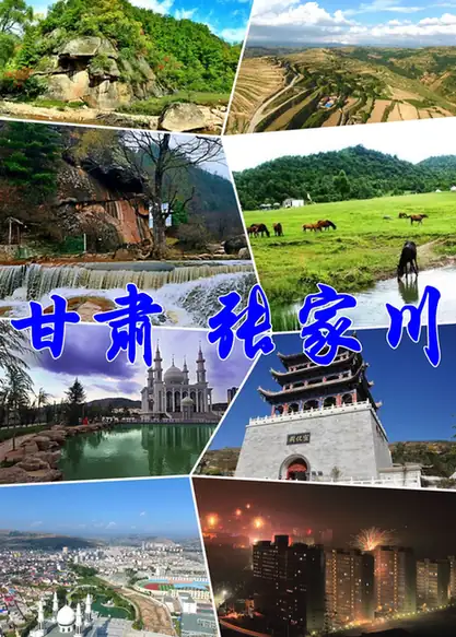
Photo adjustments
EXIF orientation normalized; resized without changing aspect ratio; converted to WebP. No subject edits.
- Administrative area
- Autonomous county · 自治县
- Part of
- Tianshui
- Chinese name
- 张家川回族自治县
- Local areas
- Autonomous county guide
Area & population
- Area in the source
- 1,311.80 km²
- Population · 2020 census
- 244,406
- Administrative seat
- Zhangjiachuan Town
Source: cited geographic source, as of the dates shown.
Setting and landscape
The county sits high, at an average altitude of 2,011.4 m, with a mean annual temperature of 8.1 °C. Its five rivers all flow to the Wei (渭河) from the north side. Yunfeng Mountain (云凤山), the Qinjiayuan (秦家塬) uplands and the Ping'an grassland (平安草原) are among its scenic areas.
History
The county government calls Zhangjiachuan one of the birthplaces of the Qin people. In 885 BC King Xiao of Zhou (周孝王) made Feizi (非子), rewarded for raising horses, a vassal with a settlement at present-day Waquan village (瓦泉村) in Zhangjiachuan town. Under the Western Han, Long county (陇县) had its seat at today's county town, and from AD 42 to 188 the Liang province inspectorate (凉州刺史部) was based there. Later the area was split between Qingshui and Qin'an counties.
The present county was formed on 6 July 1953 from 37 townships of Qingshui, Qin'an, Zhuanglang (庄浪) and Long County in Shaanxi as a Hui autonomous region, and became an autonomous county in June 1955. From 1958 to 1961 it was merged with Qingshui. The county is sometimes called Ayang (阿阳), after a Western Han county that covered part of its area.
What to see
The Guanlong Ancient Road (关陇古道), part of the eastern Silk Road between the Guanzhong plain and the west, crosses the whole county. Surviving remains include the Changning (长宁驿) and Zhangmian (张棉驿) post stations, a stone-paved road at Laoyeling (老爷岭) and the Eastern Han Heyu cliff inscriptions (河峪摩崖石刻). Qinjiayuan, a high meadow in Gongmen (恭门镇), is linked with Feizi's horse herds and is called the "Qin emperor's pasture".
The Majiayuan Chariot Museum (马家塬车舆博物馆) was built on the strength of the Majiayuan site (马家塬遗址), named one of China's hundred major archaeological discoveries of the century, and shows Rong ceremonial chariots with gold and silver fittings from the Spring and Autumn and Warring States periods.
Food and culture
Zhangjiachuan hua'er (张家川花儿) folk song is a national intangible heritage item. Catering is one of the county's four specialty industries, and the "Zhangjiachuan Lanzhou beef noodles" brand has close to 20,000 restaurants across China.
Highlights
- Majiayuan Chariot Museum 马家塬车舆博物馆: Rong ceremonial chariots and gold and silver fittings from the Majiayuan site.
- Guanlong Ancient Road 关陇古道: Silk Road route crossing the county, with post stations and the Heyu cliff inscriptions.
- Qinjiayuan 秦家塬: High meadow in Gongmen linked with Feizi and early Qin horse-rearing.
- Zhangjiachuan hua'er 张家川花儿: Folk song form on the national intangible heritage list.
Sources for this guide
基本概况-张家川回族自治县人民政府 · Zhangjiachuan Hui Autonomous County People's Government
历史沿革-张家川回族自治县人民政府 · Zhangjiachuan Hui Autonomous County People's Government
光影寻根,溯源大秦|跟着《大秦文公》解锁张家川千年秦文化根脉-张家川回族自治县人民政府 · Zhangjiachuan Hui Autonomous County People's Government
张家川回族自治县 - 维基百科,自由的百科全书 · Wikipedia (Chinese) · CC BY-SA 4.0
Original English written from the listed sources and checked sentence by sentence against quoted extracts by a separate reviewer. Updated 2026-09-23.
Explore Zhangjiachuan Hui Autonomous County
Core places to explore, with English and Chinese names.
Zhangjiachuan Hui Autonomous County 张家川回族自治县
Plan your visit
Getting there
Zhangjiachuan Hui Autonomous County is about 65 km in a straight line from central Tianshui. Search for 张家川回族自治县 in a map app to find stations and your accommodation.
Where to stay →More in Tianshui
Sources & geographic information
Administrative names and parent areas: Official geographic directory · Reference date 2026-09-06.
Some facts checked against 张家川回族自治县 — Wikipedia contributors, CC BY-SA 4.0.
Map data © OpenStreetMap contributors. Pins mark approximate centres, not entrances or boundaries.