


Get to know Jiexi County
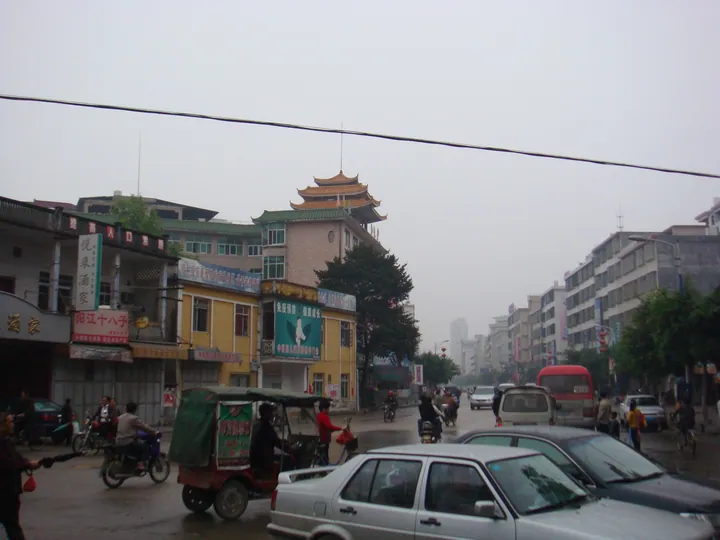
Photo adjustments
Full frame retained; proportionally resized and converted to WebP. No retouching or changes to the photographed subject. Card displays may crop the view.
- Administrative area
- County · 县
- Part of
- Jieyang
- Chinese name
- 揭西县
- Local areas
- County guide
Area & population
- Area in the source
- 1,279.00 km²
- Population · 2020
- 674,829
Source: cited geographic source, as of the dates shown.
Setting and landscape
The county lies on the southern flank of Dabei Mountain (大北山), a spur of the Lianhua Mountains (莲花山), and the land falls from northwest to southeast. The county government counts 62 per cent of the area as mountain, 24 per cent as hills and 14 per cent as plain. A range more than 60 kilometres long runs across the northwest, with six peaks above 1,000 metres; the highest, Liwangzhang (李望嶂), reaches 1,222 metres. The southeastern plain lies below 20 metres. The Tropic of Cancer crosses the county, and the South River runs 71.7 kilometres through it.
Hakka is spoken in ten townships, including Hepo (河婆), Longtan (龙潭) and Jingxiyuan (京溪园), and Teochew in seven, including Mianhu (棉湖); in villages where the two meet, people speak both.
History
Stone tools from the Xia, Shang, Zhou and pre-Qin periods have been dug up at several sites, and graves and weapons of Qin-dynasty garrison soldiers were found at Chilingpu (赤岭埔). Most of the county's land was originally part of Jieyang; Jiexi County itself was created on 19 July 1965 from twelve communes and Mianhu town of Jieyang and two communes of Lufeng. Zhou Enlai led the Eastern Expedition army in the Battle of Mianhu (棉湖战役), and Dabei Mountain later served as a Red Army base area.
What to see
The Huangmanzhai Waterfalls (黄满寨瀑布群) at Cukeng village (粗坑村) in Jingxiyuan are a national 4A scenic area and provincial geopark. Five falls step down a forested gorge: the first, Feihong Falls (飞虹瀑布), is 82 metres wide and drops 56 metres, and often shows a rainbow on sunny mornings; the third, Luojiutian Falls (落九天瀑布), drops more than 120 metres. A folk village at the site houses a geopark museum.
The county government also points to the ancestral temple of the Three Mountain Kings (三山国王祖庙), Shiling Temple (石灵寺) at Qiankeng (钱坑), and Mianhu old town (棉湖古镇) with its Blacksmith Street (打铁街), Yongchang Temple (永昌古庙), Xingdao Academy (兴道书院) and the Guo family mansion (郭氏大楼). Jiexi has 55 protected heritage sites, seven of them at provincial level.
Food and local products
Both Hakka and Teochew cooking are found here. Hakka dishes named by the county include pork braised with preserved mustard greens (咸菜焖猪肉) and stuffed tofu (酿豆腐). Among some forty local snacks are Hakka pounded tea (客家擂茶), Nanshan filled rice cakes (南山包粄), Dayang bitter bamboo shoots (大洋苦笋), sugar-frosted taro (反沙芋头) and taro paste (芋泥).
Highlights
- Huangmanzhai Waterfalls 黄满寨瀑布群: National 4A scenic area and provincial geopark in Jingxiyuan with five tiers of falls, one of them dropping more than 120 metres.
- Mianhu old town 棉湖古镇: Blacksmith Street, Yongchang Temple, Xingdao Academy and the Guo family mansion; where Zhou Enlai led the Eastern Expedition army in the Battle of Mianhu.
- Ancestral temple of the Three Mountain Kings 三山国王祖庙: Its rites are on Guangdong's second intangible-heritage list.
- Hakka pounded tea 客家擂茶: One of the county's named local snacks; lei tea making is on the municipal heritage list.
Sources for this guide
揭西简介 - 揭西县人民政府门户网站 · Jiexi County People's Government
历史沿革 - 揭西县人民政府门户网站 · Jiexi County People's Government (Jiexi County Archives)
景点景区 - 揭西县人民政府门户网站 (黄满寨瀑布旅游区) · Jiexi County Bureau of Culture, Radio, Television, Tourism and Sports
Original English written from the listed sources and checked sentence by sentence against quoted extracts by a separate reviewer. Updated 2026-09-23.
Explore Jiexi County
Core places to explore, with English and Chinese names.
Places to explore around Jiexi County
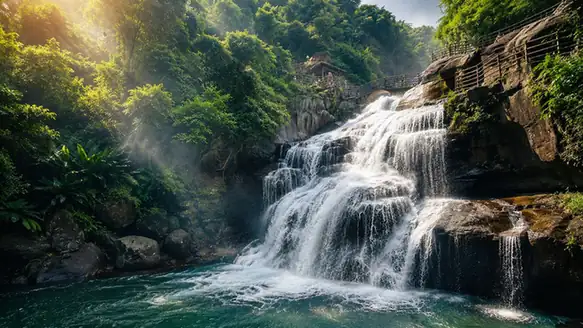 Huangmanzhai Waterfalls ·
 Plan your visit
Getting there
Jiexi County is about 55 km in a straight line from central Jieyang. Search for 揭西县 in a map app to find stations and your accommodation.
Where to stay →Build your route
Start with Huangmanzhai Waterfalls. The linked place guides have entrance and visit details.
Continue with Jieyang →More in Jieyang
Sources & geographic information
Administrative names and parent areas: Official geographic directory (dmfw.mca.gov.cn) · Reference date 2026-09-06.
Photo: Huangmanzhai Waterfalls · Source photographer · License not provided. EXIF orientation normalized; resized without changing aspect ratio; converted to WebP. No subject edits.
Map data © OpenStreetMap contributors. Pins mark approximate centres, not entrances or boundaries.