


Get to know Meixian District
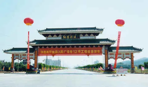
Photo adjustments
Resized and WebP compressed; subject not altered.
- Administrative area
- District · 市辖区
- Part of
- Meizhou
- Chinese name
- 梅县区
- Local areas
- District guide
Area & population
- Area in the source
- 2,755.36 km²
- Population · 2020 census
- 556,735
Source: cited geographic source, as of the dates shown.
Setting and landscape
Meixian lies between two ranges: the Xiangshan (项山) range, an offshoot of the Wuyi Mountains, in the north-west and the Yinna (阴那) range of the Lianhua Mountains in the south-east. Along the Mei River (梅江) a chain of small valley basins has formed in the fault zone between them. The district describes its land with the saying "eight parts hills, one part water, one part fields" (八山一水一分田); nine peaks top 1,000 metres, the highest being Wuzhi Peak (五指峰) on Mount Yinna at 1,297 metres. The Mei River runs for about 70 kilometres through the district, and Fujian's Shanghang (上杭) and Yongding (永定) border it to the north-east.
History
The area became Chengxiang County (程乡县) under the Southern Qi (479–502), named after the local worthy Cheng Min (程旻). In 971 the Northern Song renamed the prefecture Meizhou, and in 1733 the Qing raised it to Jiaying Prefecture (嘉应州), which with four neighbouring counties formed the "five counties of Jiaying" (嘉应五属). It took the name Meixian in 1912, and the State Council turned the county into a district of Meizhou in October 2013.
What to see
Ye Jianying, a founder of the People's Liberation Army, was born on 28 April 1897 in Xiahuxing village (下虎形村) in Yanyang (雁洋); several of the district's recommended tourist routes start at the Ye Jianying Memorial Park (叶剑英纪念园) and continue to Lingguang Temple (灵光寺) and the Yannanfei tea fields (雁南飞茶田). Songkou (松口) old town, on the district's emigrant route, has a hall on the history of emigration to Southeast Asia, a migrants' memorial square and the steamboat pier (火船码头); the Dahuang (大黄) section of the South Guangdong Ancient Post Road (南粤古驿道) is on the same route. The former homes of the Qing poet Song Xiang (宋湘) and the Republican-era general Deng Zhongyuan (邓仲元) are in Baidu (白渡) and Bingcun (丙村) respectively.
Food and local products
The district names salt-baked chicken (盐焗鸡) as its best-known dish and Meixian yanmian (梅县腌面), hand-made noodles tossed with a ready-made dressing and spring onion, as its staple, eaten with "three-champion soup" (三及第汤). Songkou's fish-flake rice noodles (松口鱼散粉) are made by boning and chopping dace, frying it, and stir-frying it with soaked rice noodles, fermented rice lees, ginger and pepper; the district describes it as a food memory of the Hakka who left for Southeast Asia. Golden pomelo, tea and Chinese mesona (仙人草) are among the district's crops.
Highlights
- Ye Jianying Memorial Park 叶剑英纪念园: Starting point of several of the district's recommended tourist routes.
- Songkou old town 松口古镇: Emigration history hall, migrants' memorial square and old steamboat pier.
- Yannanfei tea fields 雁南飞茶田: Tea-field scenic area on the district's recommended routes.
- Meixian yanmian 梅县腌面: Hand-made noodles tossed with dressing and spring onion, eaten with three-champion soup.
- Songkou fish-flake rice noodles 松口鱼散粉: Fried dace flakes stir-fried with rice noodles and rice lees.
Sources for this guide
梅县区 - 维基百科,自由的百科全书 · Wikipedia · CC BY-SA 4.0
梅县概况--梅县区人民政府门户网站 · Meixian District People's Government (Meixian Yearbook 2025)
梅县区精品旅游路线推荐--梅县区人民政府门户网站 · Meixian District People's Government
梅县腌面--梅县区人民政府门户网站 · Meixian District People's Government
叶剑英--梅县区人民政府门户网站 · Meixian District People's Government
松口鱼散粉--梅县区人民政府门户网站 · Meixian District People's Government
Original English written from the listed sources and checked sentence by sentence against quoted extracts by a separate reviewer. Updated 2026-09-25.
Explore Meixian District
Core places to explore, with English and Chinese names.
Places to explore around Meixian District
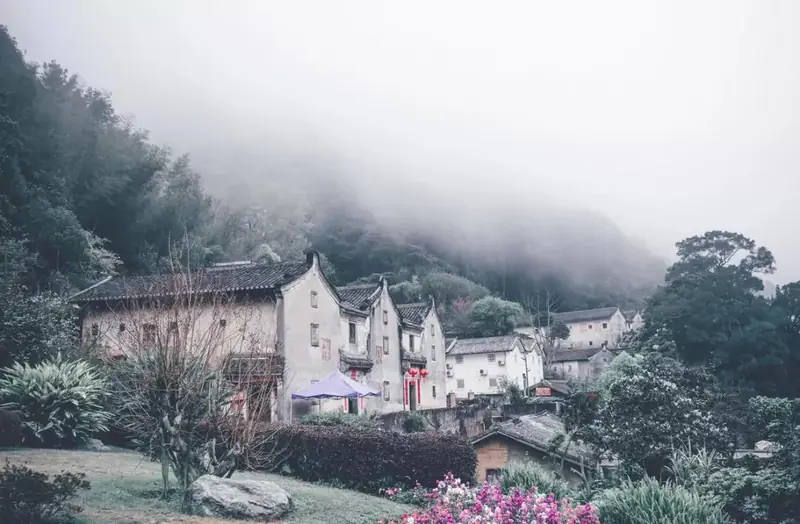 Qiaoxi Heritage Village · 桥溪古韵
Qiaoxi Heritage Village桥溪古韵
Qiaoxi Gu Yun (桥溪古韵) is an eco-tourism attraction that Qiaoxi Village, in Yanyang Town, Meixian District, in Guangdong's Meizhou prefecture, has created by making use of its well-preserved Hakka dwellings; the village's old dwellings building group is protected together as one Guangdong provincial heritage unit.
Read the place guide →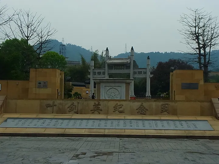 The entrance gate and inscribed stone wall of Ye Jianying Memorial Park in Meizhou, Guangdong · 广东梅州叶剑英纪念园入口牌坊及刻字墙 Source-recorded photograph date: 2011-03-27.
Ye Jianying Memorial Park叶剑英纪念园
Ye Jianying Memorial Park combines a modest Hakka family house with a much larger modern memorial. The late-Qing dwelling uses earth and lime construction and a single entrance; only part of its rooms belonged to Ye’s immediate…
Read the place guide →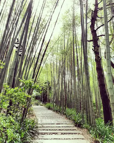 Yannanfei Tea Garden · 雁南飞茶田
Yannanfei Tea Garden雁南飞茶田
Yannanfei combines cultivated tea fields with orchards, wooded hills and resort architecture. Tea-viewing pavilions make the planted rows the focus, while the tea-art venue provides a different way to approach the crop when…
Read the place guide →Plan your visit
Getting there
Meixian District is about 4 km in a straight line from central Meizhou. Search for 梅县区 in a map app to find stations and your accommodation.
Where to stay →Build your route
Qiaoxi Heritage Village and Ye Jianying Memorial Park are both listed here. The linked place guides have entrance and visit details.
Continue with Meizhou →More in Meizhou
Sources & geographic information
Administrative names and parent areas: Official geographic directory · Reference date 2026-09-06.
Some facts checked against 梅县区 — Wikipedia contributors, CC BY-SA 4.0.
Photo: Qiaoxi Heritage Village · Source photographer · License not provided. EXIF orientation normalized; resized without changing aspect ratio; converted to WebP. No subject edits.
Photo: Ye Jianying Memorial Park · 9old9 · CC BY-SA 3.0. Full frame retained; proportionally resized and converted to WebP. No retouching or changes to the photographed subject. Card displays may crop the view.

Photo: Yannanfei Tea Garden · Source photographer · License not provided. EXIF orientation normalized; resized without changing aspect ratio; converted to WebP. No subject edits.
Map data © OpenStreetMap contributors. Pins mark approximate centres, not entrances or boundaries.