


Get to know Fangcheng District

Photo adjustments
Full frame retained; proportionally resized and converted to WebP. No retouching or changes to the photographed subject. Card displays may crop the view.
- Administrative area
- District · 市辖区
- Part of
- Fangchenggang
- Chinese name
- 防城区
- Local areas
- District guide
Area & population
- Area in the source
- 2,445.00 km²
- Population · 2020
- 390,961
Source: cited geographic source, as of the dates shown.
History
The name Fangcheng dates from the Song, when the area belonged to Qinzhou (钦州). In 1888 the western part of Qinzhou became Fangcheng County, under Guangdong. The county moved between Guangdong and Guangxi several times and was merged into the Dongxing multi-ethnic autonomous county (东兴各族自治县) in 1958. In 1978 the county seat moved from Dongxing to Fangcheng town and the county became the Fangcheng multi-ethnic autonomous county (防城各族自治县). On 23 May 1993 the State Council abolished the county and set up Fangchenggang city, with Fangcheng as one of its two districts.
The district government lists the former residence of Liu Yongfu (刘永福故居), the Bailong fort (白龙古炮台), the Tanpeng ancient canal (潭蓬古运河) and the old town of Naliang (那良古镇) among its historic sites.
What to see
Bailang Beach (白浪滩), a 4A scenic area in the northeast of the Jiangshan Peninsula (江山半岛), is named for its rolling lines of white surf. It is about 8 kilometres long and up to 2.8 kilometres wide, and the district government calls it China's largest beach. The fine sand is white flecked with black from titanium ore, and the gentle slope leaves a tidal flat several hundred metres wide, used for beach sports and sand-car driving.
Inland, the Beilun River Source scenic area (北仑河源头景区), a 3A site at Liushi village in Naliang town, lies 72 kilometres from the district seat next to the Vietnamese border and offers rafting, climbing and camping. At Dongzhong town (峒中镇) on the border, hot springs flow at about 38 to 48°C; local people and garrison soldiers have bathed there since the Daoguang reign of the Qing.
Culture and local products
Golden camellia (金花茶), nicknamed the "giant panda of the plant world", grows mainly in Fangcheng, which in 2015 became the first national protected ecological origin area for the plant. The Daban Yao (大板瑶) of Dongzhong and Naliang hold the Abao Festival (阿宝节), "abao" meaning a gathering or date in the Yao language, on the fourth day of the third lunar month and the seventh day of the seventh. Meeting sweethearts and singing love songs are the heart of it, and the Panwang dance (盘王舞) honours the ancestor Panwang (盘王). The festival joined the Guangxi regional intangible heritage list in 2008.
Getting oriented
The district lies 20 kilometres from the port of Fangchenggang. The Beilun River Source area is 190 kilometres from Nanning (南宁).
Highlights
- Bailang Beach 白浪滩: 4A beach on the Jiangshan Peninsula, about 8 km long and up to 2.8 km wide, with titanium-darkened sand.
- Beilun River Source Scenic Area 北仑河源头景区: 3A area in Naliang town beside the Vietnamese border, with rafting and camping.
- Dongzhong Hot Spring 峒中温泉: Border hot spring at about 38-48°C, used for bathing since the Daoguang reign.
- Abao Festival 阿宝节: Daban Yao festival of song and courtship, on the Guangxi intangible heritage list since 2008.
- Golden camellia 金花茶: Rare camellia found mainly in Fangcheng; national protected origin area since 2015.
Sources for this guide
防城区简介 - 防城区人民政府 · Fangcheng District People's Government, Fangchenggang
防城区的历史文化 - 防城区人民政府 · Fangcheng District People's Government, Fangchenggang
白浪滩风景区 - 防城区人民政府 · Fangcheng District People's Government, Fangchenggang
北仑河源头景区(3A级景区) - 防城区人民政府 · Fangcheng District People's Government, Fangchenggang
峒中温泉 - 防城区人民政府 · Fangcheng District People's Government, Fangchenggang
瑶族“阿宝节” 简介 - 防城区人民政府 · Fangcheng District People's Government, Fangchenggang
Original English written from the listed sources and checked sentence by sentence against quoted extracts by a separate reviewer. Updated 2026-09-24.
Explore Fangcheng District
Core places to explore, with English and Chinese names.
Places to explore around Fangcheng District
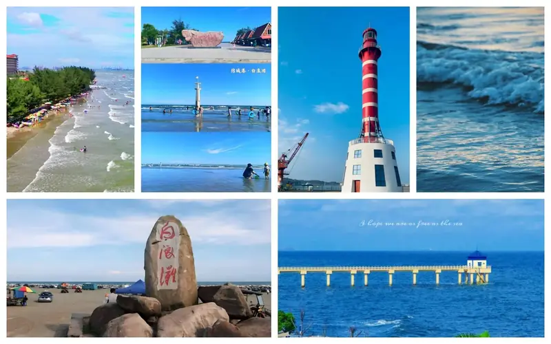 Bailang Beach ·
 Plan your visit
Getting there
Fangcheng District is about 9 km in a straight line from central Fangchenggang. Search for 防城区 in a map app to find stations and your accommodation.
Where to stay →Build your route
Start with Bailang Beach. The linked place guides have entrance and visit details.
Continue with Fangchenggang →More in Fangchenggang
Sources & geographic information
Administrative names and parent areas: Official geographic directory · Reference date 2026-09-06.
Photo: Bailang Beach · Source photographer · License not provided. EXIF orientation normalized; resized without changing aspect ratio; converted to WebP. No subject edits.
Map data © OpenStreetMap contributors. Pins mark approximate centres, not entrances or boundaries.