


Get to know Gangkou District

Photo adjustments
Full frame retained; proportionally resized and converted to WebP. No retouching or changes to the photographed subject. Card displays may crop the view.
- Administrative area
- District · 市辖区
- Part of
- Fangchenggang
- Chinese name
- 港口区
- Local areas
- District guide
Area & population
- Area in the source
- 370.00 km²
- Population · 2020 census
- 244,280
- Administrative seat
- Yuzhouping Subdistrict
Source: cited geographic source, as of the dates shown.
Setting and landscape
The district's coast runs for 317 kilometres around two peninsulas, Qisha (企沙半岛) and Yuwan (渔澫半岛), and two bays, East Bay and West Bay. It has China's first GEF international mangrove demonstration area and Qisha fishing port (企沙渔港), which the district government calls the second largest in Guangxi. Offshore lies the Beibu Gulf fishing ground, with more than 500 kinds of fish; Bryde's whales, dolphins, green turtles and the critically endangered spoon-billed sandpiper are recorded visitors.
History
Under the Qin the area belonged to Xiang Commandery (象郡). Between 1644 and 1652, according to local tradition, the Ming general Yang Yi (杨义), fleeing Qing troops, began a canal known as the Emperor's Ditch (皇帝沟), 12 kilometres long; about 500 metres were never dug, and only traces remain. On 15 November 1939 Japanese troops landed at Qisha. The district was created in May 1993, when the Fangchenggang port zone and the Fangcheng autonomous county were abolished.
What to see
The West Bay scenic area (西湾旅游景区), in the city centre, became a 4A scenic area on 31 December 2014. Its seafront parks include Xianrenshan Park (仙人山公园), the Fubo culture park (伏波文化园), Egret Park (白鹭公园) and the Beibu Gulf marine culture park.
Leshan Ancient Fishing Village (簕山古渔村) sits on a small peninsula on the southeast side of the Qisha Peninsula, 11 kilometres from Qisha town and about 25 kilometres from the city centre; the district government calls it one of Guangxi's more complete surviving old fishing villages. Most villagers are named Li, descended from a clan that the village story says settled here in the Ming. Visitors can see the Li family fort (李庄古堡), first built in the Ming, sand dunes known as the "southern snowfield", old looking-glass mangrove trees (银叶树) and a banyan that regrew after a typhoon uprooted it. Most villagers live by raising and catching sand worms (沙虫).
Food and local culture
The Qisha Peninsula is where Fangchenggang's Tanka (疍家) boat-dwelling culture began, and Qisha town remains the main Tanka community. Tanka women make fish sauce (鱼露) by salting green scale fish (青鳞鱼) with sea salt at five to one and letting it ferment in sealed jars until it turns amber; before eating, they add fried soybeans and star anise to remove the fishy smell. Tanka saltwater songs (咸水歌) and Tanka weddings have been on the city's intangible heritage list since 2010.
Highlights
- West Bay Scenic Area 西湾旅游景区: 4A seafront scenic area in the city centre since 31 December 2014, with Xianrenshan Park and Egret Park.
- Leshan Ancient Fishing Village 簕山古渔村: Fishing village on the Qisha Peninsula with a Ming-era fort, dunes and old looking-glass mangrove trees.
- Qisha fishing port 企沙渔港: Fishing port called the second largest in Guangxi by the district government.
- Tanka fish sauce 鱼露: Fish fermented with sea salt at five to one until amber, a staple seasoning of Tanka kitchens.
Sources for this guide
港口区概况 - 港口区人民政府 · Gangkou District People's Government, Fangchenggang
人文历史 - 港口区人民政府 · Gangkou District People's Government, Fangchenggang
簕山古渔村 - 港口区人民政府 · Gangkou District People's Government, Fangchenggang
西湾旅游景区 - 港口区人民政府 · Gangkou District People's Government, Fangchenggang
疍家文化 - 港口区人民政府 · Gangkou District People's Government, Fangchenggang
Original English written from the listed sources and checked sentence by sentence against quoted extracts by a separate reviewer. Updated 2026-09-24.
Explore Gangkou District
Core places to explore, with English and Chinese names.
Places to explore around Gangkou District
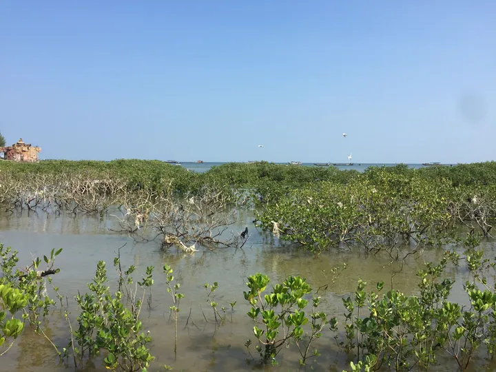 Mangrove wetland fringing the coast at Leshan Ancient Fishing Village, Gangkou District, Fangchenggang ·
 Plan your visit
Getting there
Gangkou District is about 5 km in a straight line from central Fangchenggang. Search for 港口区 in a map app to find stations and your accommodation.
Where to stay →Build your route
Start with Leshan Ancient Fishing Village. The linked place guides have entrance and visit details.
Continue with Fangchenggang →More in Fangchenggang
Sources & geographic information
Administrative names and parent areas: Official geographic directory · Reference date 2026-09-06.
Photo: Leshan Ancient Fishing Village · 安条矶子 · CC BY-SA 4.0. Full frame retained; proportionally resized and converted to WebP. No retouching or changes to the photographed subject. Card displays may crop the view.

Map data © OpenStreetMap contributors. Pins mark approximate centres, not entrances or boundaries.