


Get to know Zhenning Buyei and Miao Autonomous County
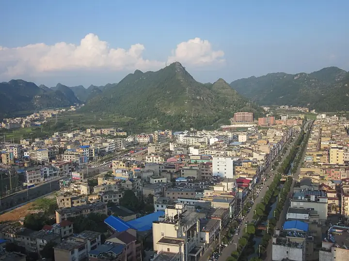
Photo adjustments
Full-frame source proportionally resized and converted to WebP for display. No subject alteration. Source-supplied marks and edits remain; cards may crop the view.
- Administrative area
- Autonomous county · 自治县
- Part of
- Anshun City
- Chinese name
- 镇宁布依族苗族自治县
- Local areas
- Autonomous county guide
Area & population
- Area in the source
- 1,709.42 km²
- Population · 2020 census
- 299,696
- Administrative seat
- Huancui Subdistrict
Source: cited geographic source, as of the dates shown.
Setting and landscape
The land falls from north to south, from 1,678 metres on Maocaopo (茅草坡山) in the north-east to 356 metres where the Beipan River (北盘江) leaves the county at Liangtian (良田). Karst covers more than 60 percent of the county, and the county government lists caves, underground rivers, waterfalls, lakes and springs among its features. Because of the drop in height, the climate changes from north to south, spanning several vertical climate belts from warm-temperate to south-subtropical.
History
The name dates from 1351, when the Yuan renamed Hehong prefecture (和宏州) as Zhenning prefecture (镇宁州). In 1390 the Ming set up a garrison at Naji fort (纳吉堡), the site of today's county town, and named it the Anzhuang Guard (安庄卫) after a strange rock called Anzhuang inside the fort. The prefecture moved into the garrison town in 1532, and the Qing merged the guard into the prefecture in 1671. Zhenning became a county in 1914, was joined with Guanling from 1958 to 1961, and became an autonomous county on 11 September 1963.
What to see
The county lies between the Huangguoshu and Longgong (龙宫) national 5A scenic areas and has two 4A areas of its own: Yelang Cave (夜郎洞) and Gaodang (高荡), a Buyei village the county government describes as a thousand years old. In the county town's south street, a Catholic church built by foreign priests from large squared stone blocks stands beside a cycad over a hundred years old.
Zhuwang village (竹王村) in Jianglong town (江龙镇) is on the national list of traditional villages. Its Mengzheng (蒙正) Miao build houses of stone with stone-slab roofs and regard the Bamboo King of Yelang (夜郎竹王) as their ancestor. Their Bamboo King worship, listed as provincial intangible heritage in 2007, is marked with an ox sacrifice on the 12th day of the second lunar month; the Tiaohua festival (跳花节) on the 12th of the seventh month brings reed pipes, suona horns, crossbow contests and antiphonal singing.
Food and local products
Zhenning cherries, fengtang plums (蜂糖李), batik and embroidery carry geographical-indication status. Local specialities include bobo sugar (波波糖) and beef jerky, and breakfast stalls serve fried egg cakes and waterfall fish (瀑布鱼).
Getting oriented
The county seat is 27 km from Anshun and 122 km from Guiyang (贵阳). The Shanghai–Kunming, Huixing and Duxiang expressways and the Shanghai–Kunming high-speed railway serve the county, and the Bacao port area (坝草港区) of Anshun port sits on the middle and lower Beipan River inside Zhenning.
Highlights
- Huangguoshu Waterfall 黄果树瀑布: Lies within the county, which is known as the waterfall county.
- Gaodang 高荡: Buyei village described as a thousand years old; national 4A scenic area.
- Yelang Cave 夜郎洞: National 4A scenic area.
- Zhuwang village 竹王村: Stone-built Mengzheng Miao village where the Bamboo King of Yelang is honoured.
Sources for this guide
镇宁简介-镇宁县人民政府门户网 · Zhenning Buyei and Miao Autonomous County People's Government
历史沿革-镇宁县人民政府门户网 · Zhenning Buyei and Miao Autonomous County People's Government
中国传统村落 | 镇宁·竹王村 · Zhenning Buyei and Miao Autonomous County People's Government
镇宁布依族苗族自治县 · Wikipedia (Chinese) · CC BY-SA 4.0
Original English written from the listed sources and checked sentence by sentence against quoted extracts by a separate reviewer. Updated 2026-09-24.
Explore Zhenning Buyei and Miao Autonomous County
Core places to explore, with English and Chinese names.
Zhenning Buyei and Miao Autonomous County 镇宁布依族苗族自治县
Plan your visit
Getting there
Zhenning Buyei and Miao Autonomous County is about 30 km in a straight line from central Anshun City. Search for 镇宁布依族苗族自治县 in a map app to find stations and your accommodation.
Where to stay →More in Anshun City
Sources & geographic information
Administrative names and parent areas: Official geographic directory · Reference date 2026-09-06.
Some facts checked against 镇宁布依族苗族自治县 — Wikipedia contributors, CC BY-SA 4.0.
Map data © OpenStreetMap contributors. Pins mark approximate centres, not entrances or boundaries.