


Get to know Pingba District
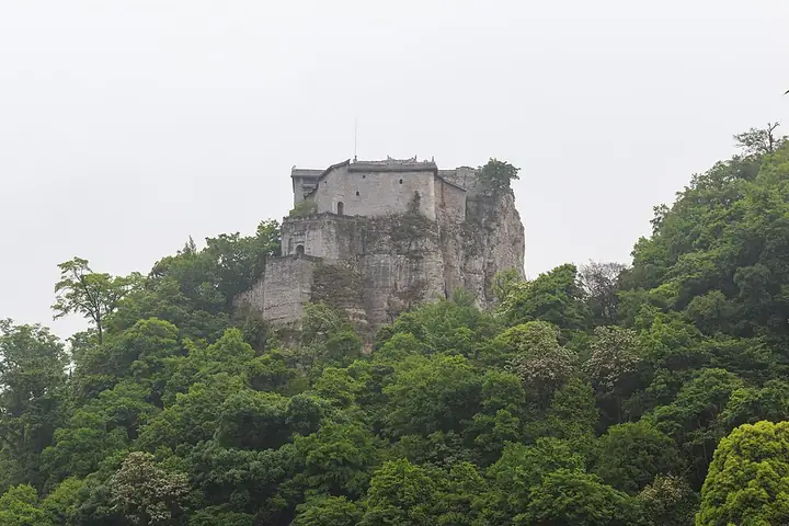
Photo adjustments
Full-frame source proportionally resized and converted to WebP for display. No subject alteration. Source-supplied marks and edits remain; cards may crop the view.
- Administrative area
- District · 市辖区
- Part of
- Anshun City
- Chinese name
- 平坝区
- Local areas
- District guide
Area & population
- Area in the source
- 985.49 km²
- Population · 2010
- 298,034
- Administrative seat
- Anping
Source: cited geographic source, as of the dates shown.
Setting and landscape
Pingba lies midway down the stepped eastern slope of the Yunnan–Guizhou Plateau, between the Sancha River (三岔河) on the upper Wu River (乌江) and Hongfeng Lake (红枫湖). The ground is higher in the north-west and flatter in the centre and south-east, from 963 to 1,645.6 metres, with the town centre at 1,250 metres. Carbonate rock gives a typical karst landscape of peak forests, peak clusters, caves and sinkholes. Seventeen rivers, all in the Yangtze system, cross the district, among them the Yangchang (羊昌河) and Leping (乐平河). The climate is humid subtropical monsoon, averaging 6.0°C in January and 23.5°C in July.
History
Under the Ming, a relay post called Shazuo (沙作站) was set up here in 1382 because the road passed through. In 1390 the Pingba Guard (平坝卫) was founded, a combined military and civil garrison with five battalions; the name means "much flat, open land". In 1687 the Qing abolished the guard and created Anping County (安平县), renamed Pingba County in 1914. The State Council approved the change to a district in December 2014, and the district was formally set up on 4 May 2015. Pingba also lies in the core of the Gui'an New Area (贵安新区), approved in January 2014.
What to see
Tianlong Tunpu is billed by the district as a "Ming legacy": a village of stone roofs, houses, streets and walls, where visitors walk old lanes, hear the local dialect and meet the customs of Ming-era Jiangnan (江南). At its dixi (地戏, "ground opera") stage, Gu Jiashun (顾家顺), a provincial-level bearer of intangible heritage, leads tunpu dixi performances; the district lists Anshun dixi (安顺地戏) as national intangible heritage. The Tianlong school house (天龙学堂) is described as a century-old landmark of learning in the tunpu area.
On Tiantai Mountain (天台山), the Wulong Temple (伍龙寺) complex, begun in 1590, is a national key protected site praised as a model of highland stone building; the mountain belongs to the provincial Tiantai Mountain–Sila River (斯拉河) scenic area of high cliffs, deep valleys and clustered karst caves. Other listed spots are the Feihushan (飞虎山) ancient human site, a provincial protected site; Xiaohewan (小河湾), a Miao village enclosed on three sides by the Wenshu River (文殊河); and Liyang Aviation Town (黎阳航空小镇), where old Third Front factory buildings house an aviation science museum.
Getting oriented
The Shanghai–Kunming and Xiamen–Chengdu expressways cross the district, and the Shanghai–Kunming high-speed railway and the Zhuzhou–Liupanshui line run through it.
Highlights
- Tianlong Tunpu 天龙屯堡: Stone-built tunpu village where tunpu dixi is performed.
- Wulong Temple, Tiantai Mountain 天台山伍龙寺: Stone temple complex begun in 1590; national key protected site.
- Xiaohewan 小河湾: Miao village enclosed on three sides by the Wenshu River; 4A scenic area.
- Liyang Aviation Town 黎阳航空小镇: Third Front factory buildings with an aviation science museum.
Sources for this guide
平坝简介-平坝区人民政府 · Pingba District People's Government, Anshun
自然地理-平坝区人民政府 · Pingba District People's Government, Anshun
历史沿革-平坝区人民政府 · Pingba District People's Government, Anshun
文化旅游-平坝区人民政府 · Pingba District People's Government, Anshun
贵州村史村事文化传播活动走进平坝天龙屯堡 · Pingba District Media Centre, on the Pingba District People's Government portal
Original English written from the listed sources and checked sentence by sentence against quoted extracts by a separate reviewer. Updated 2026-09-24.
Explore Pingba District
Core places to explore, with English and Chinese names.
Places to explore around Pingba District
 A stone gateway and bridge approach at Tianlong Tunbao, Anshun; 8 August 2017.
Plan your visit
Getting there
Pingba District is about 35 km in a straight line from central Anshun City. Search for 平坝区 in a map app to find stations and your accommodation.
Where to stay →Build your route
Start with Tianlong Tunbao. The linked place guides have entrance and visit details.
Continue with Anshun City →More in Anshun City
Sources & geographic information
Administrative names and parent areas: Official geographic directory · Reference date 2026-09-06.
Photo: Tianlong Tunbao · Huangdan2060 · CC BY 3.0. Proportionally resized and converted to WebP without cropping, retouching or changing the photographed subject.

Map data © OpenStreetMap contributors. Pins mark approximate centres, not entrances or boundaries.