


Get to know Liuzhi Special District
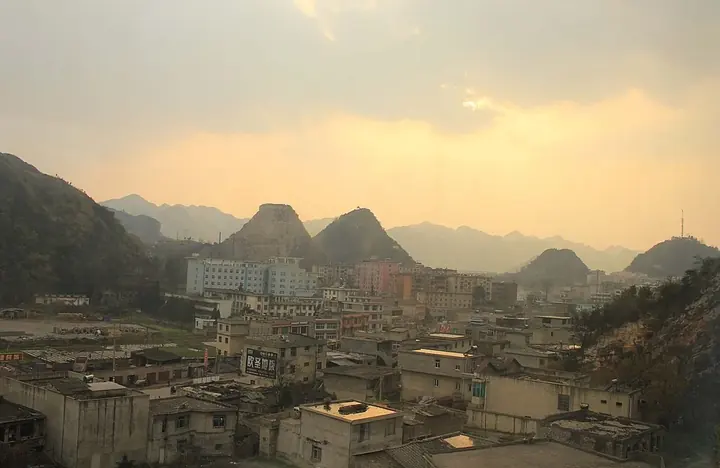
Photo adjustments
Full frame retained; proportionally resized and converted to WebP. No retouching or changes to the photographed subject. Card displays may crop the view.
- Administrative area
- Special district · 特区
- Part of
- Liupanshui City
- Chinese name
- 六枝特区
- Local areas
- Special district guide
Area & population
- Area in the source
- 1,792.10 km²
- Population · 2010
- 729,000
- Administrative seat
- Jiulong
Source: cited geographic source, as of the dates shown.
History
Until 1960 the area was known as Langdai (郎岱). The Qing set up Langdai sub-prefecture (郎岱厅) in 1731, which became Langdai County in 1913. In 1960 the county was turned into Liuzhi city and in 1962 into Liuzhi County. In 1964 a southwest coal-mine construction headquarters was set up to explore and develop mines around Liuzhi, Panxian (盘县) and Shuicheng (水城). In 1966 Liuzhi Special District was formed from eight communes of Liuzhi, Puding (普定) and Zhenning (镇宁) counties, and Liuzhi County took back the name Langdai. That Langdai County was merged into the special district in 1970, and the district has belonged to Liupanshui city since 1978.
Setting and landscape
Zhenning and Puding lie to the east, Guanling (关岭) to the south, and Zhijin (织金) and Nayong (纳雍) to the north. The ground is high in the northwest and low in the southeast, broken up by deep valleys, and averages about 1,350 metres. More than 40 rivers run through the district, draining to both the Yangtze and the Pearl River systems, with karst caves and underground rivers. The climate is a warm, humid subtropical monsoon type, averaging 14.5°C over the year.
What to see
The Suoga Eco-Museum opened in 1998 in Suoga township (梭戛苗族彝族回族乡), at about 1,700 metres in the north of the district. The Liupanshui city government calls it Asia's first ethnic-culture eco-museum. It has no walls: it is made up of 12 villages of the Qing Miao (箐苗), covering more than 120 square kilometres, plus an information centre at Longga village (陇戛寨). The Qing Miao are called Long-horn Miao after the horn-like headdress they wear; their dyed and embroidered clothing is on the national intangible-heritage list. On festive dress, long hair is wound onto a wooden horn about 1.5 chi long, making a bun of around 2 kilograms.
In Langdai town, a stretch of the old city wall survives, about 150 metres long and built of dressed stone set in lime. The walled town was finished in 1759 and had four gates. Other sights in the district include the Yuelianghe Yelang Buyei cultural eco-park (月亮河夜郎布依文化生态园), Laowang Mountain (老王山) and Huadehe provincial forest park (花德河省级森林公园).
Food and local products
Yanjiao (岩脚镇) in the district lends its name to Yanjiao stinky tofu (岩脚臭豆腐), which the Liupanshui city government describes as being seared in a hot oiled pan until it sizzles, then picked up with bamboo chopsticks or skewers and dipped in a chilli dish.
Highlights
- Suoga Eco-Museum 梭戛生态博物馆: Opened in 1998; 12 Long-horn Miao villages plus an information centre at Longga.
- Langdai old city wall 郎岱城遗址: About 150 metres of a stone wall completed in 1759.
- Yanjiao stinky tofu 岩脚臭豆腐: Pan-seared stinky tofu dipped in chilli.
Sources for this guide
六枝特区 - 维基百科 · Wikipedia (Chinese) · CC BY-SA 4.0
梭戛生态博物馆:生态村落 民俗诗歌 · Liupanshui Municipal People's Government
梭戛长角苗染色服饰(国家级非物质文化遗产) · Liupanshui Municipal People's Government
郎岱城遗址 · Liupanshui Municipal People's Government
岩脚臭豆腐 · Liupanshui Municipal People's Government
Original English written from the listed sources and checked sentence by sentence against quoted extracts by a separate reviewer. Updated 2026-09-24.
Explore Liuzhi Special District
Core places to explore, with English and Chinese names.
Liuzhi Special District 六枝特区
Plan your visit
Getting there
Liuzhi Special District is about 75 km in a straight line from central Liupanshui City. Search for 六枝特区 in a map app to find stations and your accommodation.
Where to stay →More in Liupanshui City
Sources & geographic information
Administrative names and parent areas: Official geographic directory · Reference date 2026-09-06.
Some facts checked against 六枝特区 — Wikipedia contributors, CC BY-SA 4.0.
Map data © OpenStreetMap contributors. Pins mark approximate centres, not entrances or boundaries.