


Get to know Shunping County
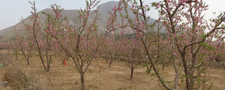
Photo adjustments
Full frame retained; proportionally resized and converted to WebP. No retouching or changes to the photographed subject. Card displays may crop the view.
- Administrative area
- County · 县
- Part of
- Baoding
- Chinese name
- 顺平县
- Local areas
- County guide
Area & population
- Population · 2020 census
- 269,678
Source: cited geographic source, as of the dates shown.
Setting and landscape
The land sits in the middle of an alluvial fan and falls from northwest to southeast; the Tang (唐河) and Ni (逆河) rivers flow all year. In Shennan Town (神南镇), Tang River irrigation supports rice paddies, rare in north China, and the Sanmiaofeng scenic area (三妙峰), a 3A site whose main peak rises to 1,016 metres, takes in a gorge of streams and waterfalls.
History
Quni County (曲逆县), created in the Spring and Autumn and Warring States era, belonged to the state of Yan. Wang Mang (王莽) renamed it Shunping in AD 5; the Jin raised it to Wanzhou (完州) in 1214, the Ming made it Wan County in 1369, and the State Council restored the name Shunping in August 1993. The seat moved to its present site in 736; the old seat is the Zicheng site (子城遗址), 10 kilometres southeast of town, a provincial protected site since 1982 with rammed-earth walls and cultural layers traced to the Shang and Zhou. The county government also cites records placing the birth of the legendary Emperor Yao (尧) on Mount Yiqi (伊祁山), 10 kilometres west of town.
What to see
The Wang family manor at Yaoshan (腰山王氏庄园), 9.5 kilometres east of the county town, was begun in 1647 and finished under Qianlong. The county government calls it the largest and best-preserved group of old houses in north China; it became a national key protected site in 2001 and has more than 300 brick, wood and stone carvings on themes of fortune, rank and long life. Its Renhe Hall (仁和堂) of ten linked courtyards has main-house steps of seven treads, against three for ordinary homes, and the manor has served as a location for more than thirty films and TV series.
The Wuhou Pagoda (伍侯塔), a Liao-dynasty six-sided brick pagoda 22.5 metres tall with glazed-tile eaves, stands 15 kilometres northeast of town and was made a national key protected site in 2013.
Food and local products
Shunping smoked pork (顺平熏肉) is simmered for two to three hours in a master stock of more than twenty medicinal herbs, including galangal, then smoked for about an hour over cypress twigs, toon bark or peachwood sawdust. Hele noodles (饸饹面) are pressed from sweet-potato flour mixed with ground elm bark and dressed with a sauce of dried cabbage. Ganglu shaobing (缸炉烧饼), a sesame flatbread, is baked against the inside wall of a jar oven. Shunping peaches are a national geographical indication product picked from May to October.
Highlights
- Wang family manor at Yaoshan 腰山王氏庄园: Qing manor begun in 1647 with over 300 carvings; national key protected site since 2001.
- Wuhou Pagoda 伍侯塔: Liao-dynasty six-sided brick pagoda, 22.5 m tall; national key protected site since 2013.
- Zicheng site 子城遗址: Old seat of Quni County, with rammed-earth walls and cultural layers traced to the Shang and Zhou.
- Shunping smoked pork 顺平熏肉: Pork simmered in an herbal master stock, then smoked over cypress, toon bark or peachwood.
Sources for this guide
顺平概况-顺平县人民政府 · Shunping County People's Government
历史沿革-顺平县人民政府 · Shunping County People's Government
顺平县重点景区简介-旅游文化-顺平县人民政府 · Shunping County People's Government
顺平县重点文保单位简介-旅游文化-顺平县人民政府 · Shunping County People's Government
顺平县特色美食简介-旅游文化-顺平县人民政府 · Shunping County People's Government
Original English written from the listed sources and checked sentence by sentence against quoted extracts by a separate reviewer. Updated 2026-09-24.
Explore Shunping County
Core places to explore, with English and Chinese names.
Shunping County 顺平县
Plan your visit
Getting there
Shunping County is about 30 km in a straight line from central Baoding. Search for 顺平县 in a map app to find stations and your accommodation.
Where to stay →More in Baoding
Sources & geographic information
Administrative names and parent areas: Official geographic directory · Reference date 2026-09-06.
Map data © OpenStreetMap contributors. Pins mark approximate centres, not entrances or boundaries.