


Get to know Jingxian
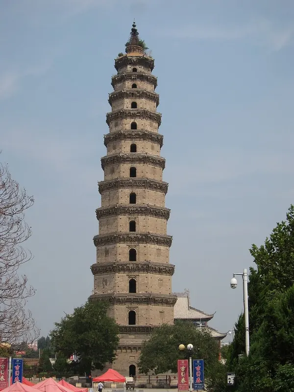
Photo adjustments
Full frame retained; proportionally resized and converted to WebP. No retouching or changes to the photographed subject. Card displays may crop the view.
- Administrative area
- County · 县
- Part of
- Hengshui
- Chinese name
- 景县
- Local areas
- County guide
History
Early in the Yuan dynasty Jingzhou (景州) was created with its seat at Tiao county (蓨县), the present Jingxian, and given five counties including Gucheng (故城) and Fucheng (阜城). The prefecture was reduced to Jing County in 1913.
The old course of the Grand Canal runs along the county's east side and is now dry. The Qianlong Emperor passed through Jingzhou on a tour of the south and left an inscription on its relic pagoda. In the late Qing, government troops crushed the Taiping Northern Expedition at Lianzhen (连镇) in the county. China Daily's Chinese service calls Jingxian the home of the Western Han Confucian scholar Dong Zhongshu (董仲舒).
What to see
The Jingzhou Pagoda (景州塔), formally the Sakyamuni Relic Pagoda of Kaifu Temple (开福寺释迦文舍利塔), is an octagonal brick-and-stone tower of thirteen storeys, 63.85 metres high. Iron plaques reading "repaired in the Qi and Sui" suggest a Northern Wei founding; it was rebuilt in Song style in 1079, and Kaifu Temple (开福寺) grew up around it in 1407. A brick stair inside climbs through the galleries to the top storey. During repairs in 1973, nine volumes of Ming woodblock sutras and a bronze reclining Buddha were found in the finial. The pagoda is counted with the Cangzhou Iron Lion (沧州铁狮子), Zhaozhou Bridge (赵州桥) and the bronze Bodhisattva of Longxing Temple (隆兴寺) as one of Hebei's four ancient treasures, and became a national protected site in 1996.
The county has two more national protected sites: the burial ground of the Bohai Feng clan (封氏墓群), dating from the Northern Wei to the Sui and listed in the first national batch in 1961, and the Gao clan cemetery (高氏墓群). The tomb of Zhou Yafu (周亚夫墓) is a provincial protected site.
Getting oriented
Jingzhou station on the Shijiazhuang–Jinan passenger railway (石济客运专线) serves the county, and national highway 339 crosses it.
Highlights
- Jingzhou Pagoda 景州塔: Thirteen-storey octagonal brick-and-stone pagoda, 63.85 m tall, rebuilt in 1079 and a national protected site since 1996.
- Feng clan cemetery 封氏墓群: Burial ground of the Bohai Feng clan from the Northern Wei to the Sui, in the first national list of 1961.
- Gao clan cemetery 高氏墓群: One of the county's three national protected sites.
- Tomb of Zhou Yafu 周亚夫墓: Provincial protected site.
Sources for this guide
景县 - 维基百科,自由的百科全书 · Chinese Wikipedia · CC BY-SA 4.0
景州塔 - 维基百科,自由的百科全书 · Chinese Wikipedia · CC BY-SA 4.0
封氏墓群 - 维基百科,自由的百科全书 · Chinese Wikipedia · CC BY-SA 4.0
河北景县中学创新发展纪实 - 中国日报网 · China Daily (Chinese edition)
衡水市人民政府 行政建制 · Hengshui Municipal People's Government
Original English written from the listed sources and checked sentence by sentence against quoted extracts by a separate reviewer. Updated 2026-09-24.
Explore Jingxian
Core places to explore, with English and Chinese names.
Plan your visit
Getting there
Jingxian is about 55 km in a straight line from central Hengshui. Search for 景县 in a map app to find stations and your accommodation.
Where to stay →More in Hengshui
Sources & geographic information
Administrative names and parent areas: Official geographic directory · Reference date 2026-09-06.
Some facts checked against 景县 — Wikipedia contributors, CC BY-SA 4.0.
Some facts checked against 景州塔 — Wikipedia contributors, CC BY-SA 4.0.
Some facts checked against 封氏墓群 — Wikipedia contributors, CC BY-SA 4.0.
Map data © OpenStreetMap contributors. Pins mark approximate centres, not entrances or boundaries.