


Get to know Wuyi County
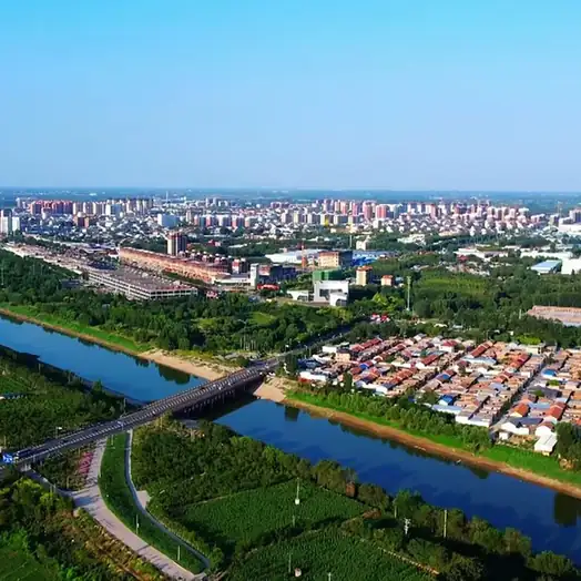
Photo adjustments
EXIF orientation normalized; resized without changing aspect ratio; converted to WebP. No subject edits.
- Administrative area
- County · 县
- Part of
- Hengshui
- Chinese name
- 武邑县
- Local areas
- County guide
Area & population
- Area in the source
- 830.00 km²
- Population · 2004
- 310,000
Source: cited geographic source, as of the dates shown.
History
Wuyi and Guanjin (观津) were both among the 17 counties of Xindu Commandery (信都郡), set up in 201 BC under the Western Han. In 286 a Wuyi Commandery was created with its seat in Wuyi County, covering Wuyi, Guanjin, Wuqiang and Wusui (武遂); it was merged into Changle Commandery (长乐郡) in 556.
From the Han survives Dou Family Hill (窦氏青山), the tomb of Dou Qing (窦青), Marquis of Ancheng and father of Empress Dou (窦皇后), consort of Emperor Wen of Han. Its mound still stands 22.9 metres high south of Qingzhong village (青冢村), and it has been a Hebei provincial heritage site since 1982. The Zhongjiao Han tomb (中角汉墓) is also on the provincial list.
What to see
In Guanjin Park (观津公园) in the county town, a path leads past a lotus lake and over a Zhuangyuan Bridge (状元桥) to Guanjin Academy (观津书院), which has a history hall and a library building. Hebei Daily also names Hengshui Wildlife Park (衡水野生动物园) and the Jiasiyuan farming-and-study culture town (贾寺院耕读文化小镇) as the county's visitor sites. At the wildlife park visitors drive through the animal areas and then continue on foot; its rescue station had taken in 3,715 wild animals since 2018 and released 1,896 by June 2024. The Hangang Expressway (邯港高速), opened by January 2025, has an exit 2,000 metres south of the park.
Food and local products
Hebei Daily lists Wuyi red pears sold by the piece, "running chickens", certified green chives, fresh sweet corn and sweet potatoes among the county's farm products. In Shijia village (史家村), Shi Guolin (史国林) makes guqin zithers by a process of more than a hundred steps that takes two to three years per instrument; his Guolin guqin making (国林古琴制作技艺) joined Hengshui's municipal intangible heritage list in 2019.
Getting oriented
The county measures 27 kilometres east to west and 42.5 kilometres north to south, with Fucheng (阜城) and Jingxian (景县) counties to the east and Botou (泊头) to the northeast; the county seat is Wuyi town. National Highways 106 and 339 cross it. The mean annual temperature is 12.5°C, with about 650 millimetres of rain a year.
Highlights
- Dou Family Hill 窦氏青山: 22.9-metre Han tomb mound of Empress Dou's father; Hebei provincial heritage site since 1982.
- Guanjin Academy 观津书院: Academy in Guanjin Park in the county town, with a history hall and a library building.
- Hengshui Wildlife Park 衡水野生动物园: Drive-through wildlife park in Wuyi with a rescue station for wild animals.
- Guolin guqin making 国林古琴制作技艺: Guqin zithers made in more than a hundred steps; Hengshui municipal intangible heritage since 2019.
Sources for this guide
衡水市人民政府 行政建制 · Hengshui Municipal People's Government
衡水:品读文旅融合新故事 · Hebei Daily (via People's Daily Online, Hebei channel)
衡水野生动物园 2024 年度精彩回顾与 2025 年展望 · Wuyi County People's Government
邯港高速新通道,衡水野生动物园近在咫尺! · Wuyi County People's Government
探访河北武邑古琴制作技艺 历经上百道工序打造而成 · China News Service (Hebei)
窦氏青山 · Chinese Wikipedia · CC BY-SA 4.0
河北省文物保护单位 · Chinese Wikipedia · CC BY-SA 4.0
武邑县 · Chinese Wikipedia · CC BY-SA 4.0
Original English written from the listed sources and checked sentence by sentence against quoted extracts by a separate reviewer. Updated 2026-09-24.
Explore Wuyi County
Core places to explore, with English and Chinese names.
Wuyi County 武邑县
Plan your visit
Getting there
Wuyi County is about 20 km in a straight line from central Hengshui. Search for 武邑县 in a map app to find stations and your accommodation.
Where to stay →More in Hengshui
Sources & geographic information
Administrative names and parent areas: Official geographic directory · Reference date 2026-09-06.
Some facts checked against 窦氏青山 — Wikipedia contributors, CC BY-SA 4.0.
Some facts checked against 河北省文物保护单位 — Wikipedia contributors, CC BY-SA 4.0.
Some facts checked against 武邑县 — Wikipedia contributors, CC BY-SA 4.0.
Map data © OpenStreetMap contributors. Pins mark approximate centres, not entrances or boundaries.