


Get to know Linzhou

Photo adjustments
Full frame retained; resized proportionally to a maximum dimension of 960 pixels and converted to WebP quality 88. No crop, retouch, generated elements, or subject alteration. Final website rendition: full frame retained, proportionally resized to at most 720 pixels and converted to WebP. No additional retouching or subject alteration. Card displays may crop the view.
- Administrative area
- County-level city · 县级市
- Part of
- Anyang
- Chinese name
- 林州市
- Local areas
- County-level city guide
Area & population
- Area in the source
- 2,046.00 km²
- Population · 2019
- 815,000
Source: cited geographic source, as of the dates shown.
Setting and landscape
Mountains and hills make up 86 percent of the city's area. The land falls from the northwest to the southeast, from Sifangnao (四方垴) at 1,632 metres to about 200 metres in the northeast of Wulong (五龙镇). Along the Taihang front the surface is deeply eroded into cliffs and gorges. Limestone is widespread and full of fissures and karst caves, so surface water drains away easily. Four natural rivers run through the city: the Zhang (漳河), Huan (洹河), Xi (淅河) and Qi (淇河).
What to see
Work on the Red Flag Canal began in February 1960 and was completed in July 1969. Its main channel runs 70.6 kilometres, and with branches the network reaches about 1,500 kilometres. Builders cut through 1,250 hilltops and bored 211 tunnels. The canal scenic area is a national 5A scenic area and a national protected site.
The Taihang Grand Canyon (太行大峡谷) is described by the city government as one of China's ten most beautiful canyons, listed alongside the Yarlung Tsangpo canyon and the Three Gorges. Mount Linlü (林虑山) is praised as "the finest scenery of the rugged north" (北雄风光最胜处). The city government also points to the Peach Blossom Valley (桃花谷), a paragliding base, the southern Great Wall of Zhao (赵南长城), a cemetery of Eastern Zhou nobles and the site of the old walled town of Longlü (隆虑古城址). The headquarters of the Eighth Route Army's 129th Division was once in Xipo (西坡村), in Rencun township (任村镇).
History
The area was the town of Linlü (临虑) in the Warring States state of Han. A county named Longlü (隆虑县) was set up in 205 BC after the mountain to its west, and it was renamed Linlü (林虑县) in AD 106 to avoid the personal name of the Eastern Han emperor Shang. It became Lin prefecture in 1215 under the Jin and Lin County (林县) in 1370 under the Ming. Lin County became the city of Linzhou in January 1994.
Highlights
- Red Flag Canal 红旗渠: Built 1960–1969; main channel 70.6 km; a national 5A scenic area and national protected site.
- Linzhou Taihang Grand Canyon 林州太行大峡谷: Named by the city government among China's ten most beautiful canyons.
- Mount Linlü 林虑山: Praised as "the finest scenery of the rugged north".
Sources for this guide
林州概况_林州概况_林州市人民政府 · Linzhou City People's Government
历史沿革_历史沿革_林州市人民政府 · Linzhou City People's Government
自然地理_自然地理_林州市人民政府 · Linzhou City People's Government
红旗渠 - 维基百科,自由的百科全书 · Wikipedia (Chinese) · CC BY-SA 4.0
Original English written from the listed sources and checked sentence by sentence against quoted extracts by a separate reviewer. Updated 2026-09-25.
Explore Linzhou
Core places to explore, with English and Chinese names.
Places to explore around Linzhou
 The entrance marker for Linzhou Taihang Grand Canyon, with the canyon's cliffs behind · 林州太行大峡谷入口标志石,背后为峡谷峭壁 Source-recorded photograph date: 2020-10-16 09:46:02.
Linzhou Taihang Grand Canyon林州太行大峡谷
Linzhou Taihang Grand Canyon brings together red cliffs, stepped waterfalls and stone-built villages around Shibanyan in northern Henan. It is a separate excursion from the nearby Red Flag Canal and from Baquan Gorge across the provincial boundary in Shanxi.
Read the place guide →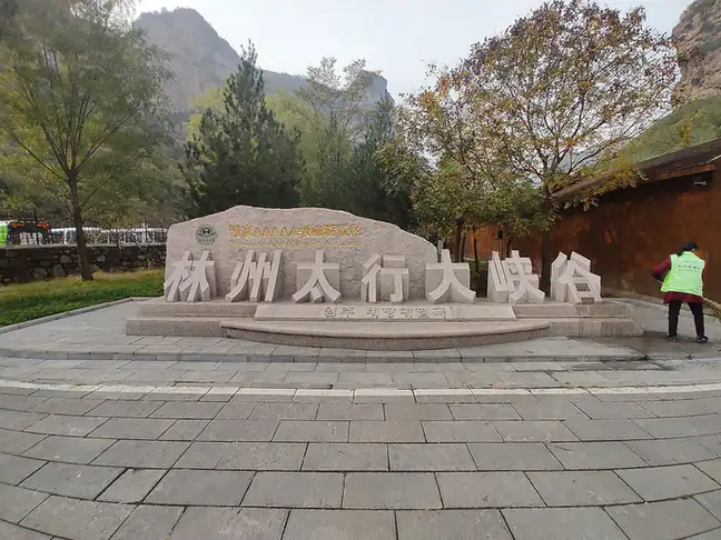 Taihang Grand Canyon · 太行大峡谷
Taihang Grand Canyon太行大峡谷
The Taihang Grand Canyon is the Linzhou section of the gorge country cut into the eastern edge of the Taihang Mountains, in Linzhou, Anyang, managed as one national scenic and historic area.
Read the place guide →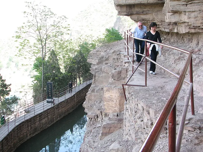 Red Flag Canal at Tigers Mouth Cliff · 红旗渠 Photograph date recorded by the source: 2006-04-23.
Red Flag Canal红旗渠
The Red Flag Canal carries water around the Taihang cliffs through channels, tunnels and aqueducts built in the 1960s. Its route makes the engineering challenge immediately visible: a narrow watercourse is held against steep…
Read the place guide →Plan your visit
Getting there
Linzhou is about 50 km in a straight line from central Anyang. Search for 林州市 in a map app to find stations and your accommodation.
Where to stay →Build your route
Linzhou Taihang Grand Canyon and Taihang Grand Canyon are both listed here. The linked place guides have entrance and visit details.
Continue with Anyang →More in Anyang
Sources & geographic information
Administrative names and parent areas: Official geographic directory · Reference date 2026-09-06.
Some facts checked against 红旗渠 — Wikipedia contributors, CC BY-SA 4.0.
Photo: Linzhou Taihang Grand Canyon · Ngguls · CC BY-SA 4.0. Full frame retained; proportionally resized and converted to WebP. No retouching or changes to the photographed subject. Card displays may crop the view.

Photo: Taihang Grand Canyon · Ngguls · CC BY-SA 4.0. EXIF orientation normalized; resized without changing aspect ratio; converted to WebP. No subject edits.

Photo: Red Flag Canal · eregli bob · Eregli bob at English Wikipedia · CC BY-SA 3.0. Full frame retained; proportionally resized and converted to WebP. No retouching or changes to the photographed subject. Card displays may crop the view.

Map data © OpenStreetMap contributors. Pins mark approximate centres, not entrances or boundaries.