


Get to know Linying County
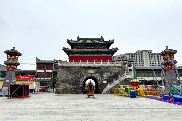
Photo adjustments
Full frame retained; proportionally resized and converted to WebP. No retouching or changes to the photographed subject. Card displays may crop the view.
- Administrative area
- County · 县
- Part of
- Luohe
- Chinese name
- 临颍县
- Local areas
- County guide
Area & population
- Area in the source
- 821.00 km²
- Population · 2019
- 736,800
Source: cited geographic source, as of the dates shown.
History
The county government describes people moving in from the north-west about five thousand years ago and settling on higher ground along the ancient Ying. The area belonged to the state of Xu (许国) in the Spring and Autumn period, to Wei (魏) in the Warring States and to Yingchuan Commandery (颍川郡) under the Qin. The county itself was set up early in the Western Han, more than 2,200 years ago.
The provincial cultural heritage bureau recognises 179 protected sites here. At national level are the Shouchan Terrace (受禅台) and its stele, which mark the handover of power from the Han to the Wei, and the Sui-dynasty Xiaoshang Bridge (小商桥). Provincial sites include the cemetery of the Song general Yang Zaixing (杨再兴) and the Dacheng Hall of the Confucian temple (文庙大成殿).
What to see
The Xiaoshang Bridge scenic area (小商桥景区) straddles the boundary between Huangdimiao township (皇帝庙乡) and Shangqiao town (商桥镇) in Yancheng District (郾城区), 10 kilometres south of the county seat. The bridge was built in 584 over the Xiaoshang River (小商河), an old course of the Ying, and repaired under every dynasty from the Song to the Qing. It is 21.3 metres long, and the county government describes it as the earliest surviving open-spandrel segmental stone arch bridge; bridge experts who surveyed it concluded that it is slightly older than the Zhaozhou Bridge (赵州桥). A memorial garden honours Yang Zaixing, an officer under Yue Fei (岳飞) who was killed here fighting the Jin after his horse became mired in the river. The bridge became a national key protected site in 2001 and the scenic area a 4A site in 2014.
Chen Xingju (陈星聚, 1817–1885), who became prefect of Taipei (台北) in 1878 and led its defence against French attacks in 1884, is buried in his home village of Taichen (台陈村). His tomb, built in 1889 with stone figures of men and animals along the spirit way, became a provincial protected site in 2008, and a memorial hall opened in the village in March 2009.
Food and local products
Linying bills itself as China's only "capital of leisure foods" (中国休闲食品之都), and Nanjie Village (南街村), which the county promotes as a "red" village, is here. Hongjia five-spice beef (洪家五香牛肉) and willow and chaste-tree weaving are on the Luohe municipal intangible-heritage list, and the county's chilli peppers are sold under the regional brand "Yingshanhong" (颍山红).
Getting oriented
The Beijing-Hong Kong-Macau Expressway, the Beijing-Guangzhou Railway and high-speed line, and National Highway 107 all cross the county, and Zhengzhou Xinzheng International Airport is 60 kilometres away.
Highlights
- Xiaoshang Bridge 小商桥: Stone arch bridge built in 584; national key protected site since 2001.
- Shouchan Terrace 受禅台: National key protected site marking the handover of power from Han to Wei.
- Chen Xingju Memorial Hall 陈星聚纪念馆: Tomb and memorial hall of the Qing prefect of Taipei in Taichen village.
- Hongjia five-spice beef 洪家五香牛肉: On the Luohe municipal intangible-heritage list.
Sources for this guide
临颍概览_走进临颍_临颍县人民政府网站 · Linying County People's Government
临颍县历史文化_临颍历史_走进临颍_临颍县人民政府网站 · Linying County People's Government
临颍县小商桥景区简介_临颍旅游_走进临颍_临颍县人民政府网站 · Linying County People's Government
陈星聚纪念馆_临颍旅游_走进临颍_临颍县人民政府网站 · Linying County People's Government
Original English written from the listed sources and checked sentence by sentence against quoted extracts by a separate reviewer. Updated 2026-09-24.
Explore Linying County
Core places to explore, with English and Chinese names.
Linying County 临颍县
Plan your visit
Getting there
Linying County is about 30 km in a straight line from central Luohe. Search for 临颍县 in a map app to find stations and your accommodation.
Where to stay →More in Luohe
Sources & geographic information
Administrative names and parent areas: Official geographic directory · Reference date 2026-09-06.
Map data © OpenStreetMap contributors. Pins mark approximate centres, not entrances or boundaries.