


Get to know Sha Tin District
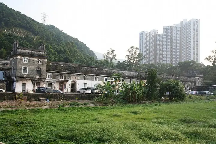
Photo adjustments
The exact downloaded source bytes are separately retained and hashed. Prepared JPEG is proportionally reduced to a maximum 720-pixel long edge; full frame retained, no subject alteration. Final website rendition: full frame retained, proportionally resized to at most 720 pixels and converted to WebP. No additional retouching or subject alteration. Card displays may crop the view.
- Administrative area
- District · 地區
- Part of
- Hong Kong
- Chinese name
- 沙田
- Local areas
- District guide
Area & population
- Area in the source
- 69.27 km²
- Population · 2021
- 692,806
Source: cited geographic source, as of the dates shown.
History
The area was once called Lek Yuen (瀝源), and most early residents farmed along the Shing Mun River. Tai Wai Village, the oldest and largest walled village in Sha Tin, dates from 1574 according to the Sha Tin District Council. The name Sha Tin replaced Lek Yuen after the Kowloon-Canton Railway opened a Sha Tin station in 1910. Much of today's new town stands on land reclaimed from Sha Tin Hoi (沙田海); growth took off after Lek Yuen Estate, the district's first public housing estate, was completed in 1976.
What to see
The Hong Kong Heritage Museum (香港文化博物館) in Tai Wai opened at the end of 2000 and covers the art, culture and history of the New Territories; the district council calls it the largest museum in Hong Kong. Che Kung Temple (車公廟) draws thousands of worshippers at Chinese New Year. Tsang Tai Uk (曾大屋), a dwelling from 1848, uses granite, green brick and timber; it has defence towers, and its ancestral hall is still in use. The council's list of ten scenic spots adds Amah Rock (望夫石), the Lion Pavilion (獅子亭), the Ten Thousand Buddhas Monastery (萬佛寺), the Chinese University of Hong Kong, Lion Rock (獅子山) and Ma On Shan. Sha Tin Racecourse, on about 70 hectares of reclaimed flat land, hosted the equestrian events of the 2008 Summer Olympics, and Penfold Park lies at its centre.
Food and outdoors
The Home Affairs Department names chicken congee, roast pigeon and Shan Shui beancurd as Sha Tin's well-known foods. Cycling has long been a feature of Sha Tin: the first cycle track opened in 1981 along the Tolo Highway to Tai Po and has since been extended to Ma On Shan, and the 3.2-kilometre Ma On Shan Waterfront Promenade looks across Sha Tin Hoi to the Pat Sin Leng (八仙嶺) peaks.
Getting oriented
Fourteen MTR stations on two lines serve the district; five of them, Tai Wai, Sha Tin, Fo Tan, University and Racecourse, are on the East Rail line. Road tunnels lead out of the district: Lion Rock Tunnel, completed in 1967 and listed by the district council as Hong Kong's first, leads to Kowloon Tong; Tate's Cairn Tunnel to Diamond Hill; and Shing Mun Tunnel to Tsuen Wan.
Highlights
- Hong Kong Heritage Museum 香港文化博物馆: Opened at the end of 2000 in Tai Wai; named by the Sha Tin District Council as Hong Kong's largest museum.
- Che Kung Temple 车公庙: Draws thousands of worshippers during Chinese New Year.
- Tsang Tai Uk 曾大屋: An 1848 dwelling with defence towers and an ancestral hall still in use.
- Ten Thousand Buddhas Monastery 万佛寺: One of the district council's ten scenic spots of Sha Tin.
Sources for this guide
Home Affairs Department - Sha Tin District · Home Affairs Department, Hong Kong SAR Government
Sha Tin District Council - District Highlights · Sha Tin District Council, Hong Kong SAR Government
Sha Tin District · Wikipedia · CC BY-SA 4.0
Original English written from the listed sources and checked sentence by sentence against quoted extracts by a separate reviewer. Updated 2026-09-25.
Explore Sha Tin District
Core places to explore, with English and Chinese names.
Places to explore around Sha Tin District
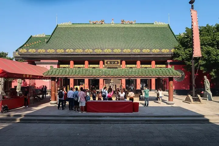 Main hall and courtyard of Che Kung Temple, Tai Wai · 大围车公庙正殿与庭院 Photograph date recorded by the source: 28 October 2018.
Che Kung Temple车公庙
Che Kung Temple in Sha Tin is centred on the worship of General Che, with a large deity statue in the current main building. Fan-bladed fortune wheels and a drum make the devotional practices visually and audibly distinctive…
Read the place guide →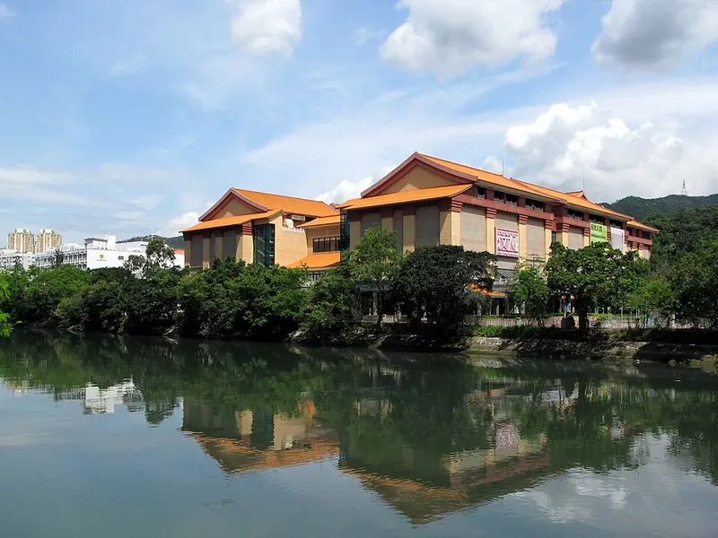 Hong Kong Heritage Museum beside the water in Sha Tin · 香港文化博物馆 Photograph date recorded by the source: 2013-05-24.
Hong Kong Heritage Museum香港文化博物馆
Hong Kong Heritage Museum stands beside the Shing Mun River in Sha Tin and combines history, art and cultural-life displays. Cantonese opera is a major collection theme, alongside material about the New Territories and Chinese…
Read the place guide → Pagoda and forecourt at Ten Thousand Buddhas Monastery · 万佛寺 Photograph date recorded by the source: 2013-09-22 23:04:49.
Ten Thousand Buddhas Monastery万佛寺
Ten Thousand Buddhas Monastery stands above Pai Tau Village in Sha Tin. Its approach is part of the attraction: a climbing path is lined with numerous golden Buddhist figures, each with a different pose or expression. At the…
Read the place guide →Exterior of Tsang Tai Uk walled village · 曾大屋围村外观 Capture date not established by the retained file page.Tsang Tai Uk曾大屋
Tsang Tai Uk is a fortified Hakka village built from grey brick, granite and timber. Its rectangular arrangement contains linked rows of houses and small courtyards, with defensive towers at the corners. From the front, the…
Read the place guide →Plan your visit
Getting there
Sha Tin District is about 8 km in a straight line from central Hong Kong. Search for 沙田 in a map app to find stations and your accommodation.
Where to stay →Build your route
Che Kung Temple and Hong Kong Heritage Museum are less than 1 km apart. The linked place guides have entrance and visit details.
Continue with Hong Kong →More in Hong Kong
Sources & geographic information
Administrative names and parent areas: Official geographic directory · Reference date 2026-09-06.
Some facts checked against Sha Tin District — Wikipedia contributors, CC BY-SA 4.0.
Photo: Che Kung Temple · Wpcpey · Wpcpey — Che_Kung_Temple_201810.jpg — CC BY-SA 4.0 · CC BY-SA 4.0. The exact downloaded source bytes are separately retained and hashed. Prepared JPEG is proportionally reduced to a maximum 720-pixel long edge; full frame retained, no subject alteration. Final website rendition: full frame retained, proportionally resized to at most 720 pixels and converted to WebP. No additional retouching or subject alteration. Card displays may crop the view.

Photo: Hong Kong Heritage Museum · Wing1990hk · CC BY 3.0. Full frame retained; proportionally resized and converted to WebP. No retouching or changes to the photographed subject. Card displays may crop the view.

Photo: Ten Thousand Buddhas Monastery · Mitchan14 · CC BY-SA 3.0. Full frame retained; proportionally resized and converted to WebP. No retouching or changes to the photographed subject. Card displays may crop the view.

Photo: Tsang Tai Uk · CPJoseph · CPJoseph — Tsang_Tai_Uk_曾大屋_o.jpg — CC BY-SA 3.0 · CC BY-SA 3.0. The exact downloaded source bytes are separately retained and hashed. Prepared JPEG is proportionally reduced to a maximum 720-pixel long edge; full frame retained, no subject alteration. Final website rendition: full frame retained, proportionally resized to at most 720 pixels and converted to WebP. No additional retouching or subject alteration. Card displays may crop the view.

Map data © OpenStreetMap contributors. Pins mark approximate centres, not entrances or boundaries.