


Get to know Tieshan District

Photo adjustments
Full frame retained; proportionally resized and converted to WebP. No retouching or changes to the photographed subject. Card displays may crop the view.
- Administrative area
- District · 市辖区
- Part of
- Huangshi
- Chinese name
- 铁山区
- Local areas
- District guide
Area & population
- Area in the source
- 28.70 km²
- Population · 2020
- 41,907
Source: cited geographic source, as of the dates shown.
History
Iron working here goes back a long way. The first recorded mining at the Daye Iron Mine (大冶铁矿) dates from 226 AD, when Sun Quan (孙权) of the Wu state set up furnaces to make weapons. In 1889 the Huguang viceroy Zhang Zhidong (张之洞) founded the Hanyang Ironworks (汉阳铁厂) and took its ore from Daye, which became the first large open-pit iron mine in China worked by machine. In 1908 the ironworks, the mine and the Pingxiang coal mine were merged into the Hanyeping Company (汉冶萍公司); the Daye mine is the only one of the three still working.
In 1932 the area was part of the 10th district of Daye County (大冶县), and in 1949 it was Tielu township (铁麓乡). Tieshan District was created in 1979. The district government calls it a "thousand-year iron town" (千年铁镇).
What to see
The Huangshi National Mine Park (黄石国家矿山公园) was built in 2007 on the site of the Daye Iron Mine and is China's first national mine park. Its centrepiece is the Mining and Smelting Grand Canyon (矿冶大峡谷), an open pit with a maximum drop of 444 metres and a mouth of 1.08 million square metres, which the Huangshi city government says is nicknamed "Asia's first tiankeng". The city also describes 2.47 million square metres of black locust planted on the mine's bare rock as Asia's largest reclaimed forest on hard rock, and notes that this was the only iron mine Mao Zedong ever inspected.
Old mine installations have been turned into visitor areas with names such as "Exploring Underground" (井下探幽) and "Nine Dragon Cave" (九龙洞天). In 2018 the park was named to the first list of protected industrial heritage in China.
Getting oriented
National Highways 106 and 316 pass through the district. The combined development zone and district now administers six towns and subdistricts, including areas taken over from Daye (大冶), Yangxin (阳新) and Xisaishan (西塞山区).
Highlights
- Huangshi National Mine Park 黄石国家矿山公园: China's first national mine park, built in 2007 on the Daye Iron Mine site.
- Mining and Smelting Grand Canyon 矿冶大峡谷: Open pit with a maximum drop of 444 m, nicknamed "Asia's first tiankeng".
- Daye Iron Mine 大冶铁矿: Mined since at least 226 AD; the only part of the Hanyeping Company still working.
Sources for this guide
黄石国家矿山公园 — 黄石政府网 · Huangshi Municipal People's Government (Culture and Tourism Bureau)
铁山区 - 维基百科 · Wikipedia (Chinese) · CC BY-SA 4.0
黄石经济技术开发区·铁山区基本概况 · Huangshi Economic and Technological Development Zone Management Committee / Tieshan District People's Government
大冶铁矿 - 维基百科 · Wikipedia (Chinese) · CC BY-SA 4.0
Original English written from the listed sources and checked sentence by sentence against quoted extracts by a separate reviewer. Updated 2026-09-24.
Explore Tieshan District
Core places to explore, with English and Chinese names.
Places to explore around Tieshan District
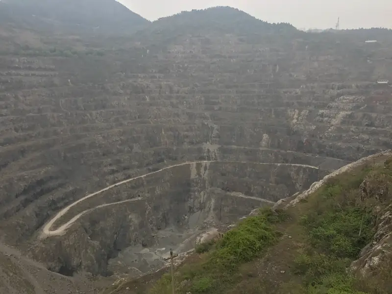 Huangshi National Mine Park ·
 Plan your visit
Getting there
Tieshan District is about 15 km in a straight line from central Huangshi. Search for 铁山区 in a map app to find stations and your accommodation.
Where to stay →Build your route
Start with Huangshi National Mine Park. The linked place guides have entrance and visit details.
Continue with Huangshi →More in Huangshi
Sources & geographic information
Administrative names and parent areas: Official geographic directory · Reference date 2026-09-06.
Some facts checked against 铁山区 — Wikipedia contributors, CC BY-SA 4.0.
Some facts checked against 大冶铁矿 — Wikipedia contributors, CC BY-SA 4.0.
Photo: Huangshi National Mine Park · Source photographer · License not provided. EXIF orientation normalized; resized without changing aspect ratio; converted to WebP. No subject edits.
Map data © OpenStreetMap contributors. Pins mark approximate centres, not entrances or boundaries.