


Get to know Nanzhang County
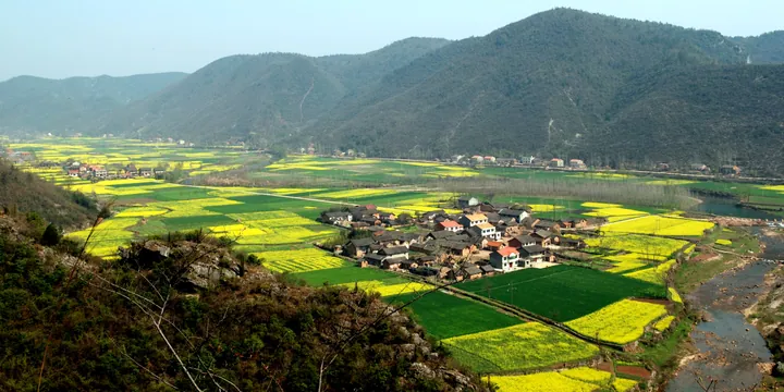
Photo adjustments
Full frame retained; proportionally resized and converted to WebP. No retouching or changes to the photographed subject. Card displays may crop the view.
- Administrative area
- County · 县
- Part of
- Xiangyang
- Chinese name
- 南漳县
- Local areas
- County guide
Area & population
- Area in the source
- 3,859.00 km²
- Population · 2020
- 455,690
Source: cited geographic source, as of the dates shown.
Setting and landscape
Land falls in steps from high mountains in the west through low hills to flat fields and ridges in the east, from 1,570 metres at Sanjian Mountain (三尖山) on the Baokang (保康) border to 65 metres at Jiebeitou (界碑头) on the Yicheng (宜城) border. A local saying puts the county at "eight parts mountain, half water, half field". The Zhang rises around Sanjingzhuang (三景庄) in Xueping town (薛坪镇) and runs south-east through Banqiao (板桥), Xunjian (巡检), Xiaoyan (肖堰) and Donggong (东巩) towards the Yangtze; only the Man River (蛮河) is larger within the county.
History
The county government presents Nanzhang as a cradle of Chu (楚) culture, placing the early Chu capital of Danyang (丹阳), founded by Xiong Yi (熊绎) below the Jing Mountains, around the present county town. It also names Yuyinyan (玉印岩) as the source of Bian He's jade (和氏璧), and credits the Qin general Bai Qi (白起) with the Bai Qi Canal (白起渠), built when he used water as a weapon. In the county government's telling the Three Kingdoms story begins here too: the hermit Sima Hui (司马徽), "Master Shuijing", lived at Shuijing Zhuang (水镜庄) south of the county town and recommended able men, which in turn led Liu Bei to seek out Zhuge Liang (诸葛亮). The county name dates from 598, and the seat has stood north of Yuxi Mountain (玉溪山) on the Man River since 1135.
What to see
The Nanzhang Mountain Fortresses (南漳山寨群), stone-built defensive strongholds raised by local people in the Ming and Qing, became a national key protected site in 2013. Chunqiu Zhai (春秋寨), at Luping village (陆坪村) in Donggong town, is ringed on three sides by the Maoping River (茅坪河); its wall runs 1,150 metres around 153 stone houses. Woniushan Zhai (卧牛山寨), also in Donggong, has a 4,181-metre wall and 375 stone houses. Provincial sites elsewhere include Shuijing Zhuang, Yuyinyan, the Changqu canal site (长渠遗址) and the old dwellings of Banqiao and Donggong.
Folk arts
The county government lists wuyin horn music (呜音喇叭), weeding songs with gongs and drums (薅草锣鼓), duangong ritual dance (端公舞) and Donggong stilt-walking (东巩高跷) among its intangible heritage.
Highlights
- Chunqiu Zhai 春秋寨: Ming–Qing stone fortress in Donggong town, ringed on three sides by the Maoping River, with 153 stone houses inside a 1,150-metre wall.
- Woniushan Zhai 卧牛山寨: Ming–Qing stone fortress in Donggong town with a 4,181-metre wall and 375 stone houses.
- Shuijing Zhuang 水镜庄: Home of the hermit Sima Hui south of the county town; a provincial protected site.
- Yuyinyan 玉印岩: Cave named by the county government as the source of Bian He's jade; a provincial protected site.
Sources for this guide
南漳简介 - 南漳县人民政府门户网站 · Nanzhang County People's Government (county archives)
南漳概况 - 南漳县人民政府门户网站 · Nanzhang County People's Government
南漳山寨群 - 维基百科,自由的百科全书 · Wikipedia (Chinese) · CC BY-SA 4.0
南漳县 - 维基百科,自由的百科全书 · Wikipedia (Chinese) · CC BY-SA 4.0
Original English written from the listed sources and checked sentence by sentence against quoted extracts by a separate reviewer. Updated 2026-09-24.
Explore Nanzhang County
Core places to explore, with English and Chinese names.
Places to explore around Nanzhang County
 Chunqiu Fortress ·
 Plan your visit
Getting there
Nanzhang County is about 35 km in a straight line from central Xiangyang. Search for 南漳县 in a map app to find stations and your accommodation.
Where to stay →Build your route
Start with Chunqiu Fortress. The linked place guides have entrance and visit details.
Continue with Xiangyang →More in Xiangyang
Sources & geographic information
Administrative names and parent areas: Official geographic directory · Reference date 2026-09-06.
Some facts checked against 南漳山寨群 — Wikipedia contributors, CC BY-SA 4.0.
Some facts checked against 南漳县 — Wikipedia contributors, CC BY-SA 4.0.
Photo: Chunqiu Fortress · Source photographer · License not provided. EXIF orientation normalized; resized without changing aspect ratio; converted to WebP. No subject edits.
Map data © OpenStreetMap contributors. Pins mark approximate centres, not entrances or boundaries.