


Get to know Leiyang

Photo adjustments
EXIF orientation normalized; resized without changing aspect ratio; converted to WebP. No subject edits.
- Administrative area
- County-level city · 县级市
- Part of
- Hengyang
- Chinese name
- 耒阳市
- Local areas
- County-level city guide
Area & population
- Area in the source
- 2,656.00 km²
- Population · 2010
- 1,150,241
Source: cited geographic source, as of the dates shown.
Setting and landscape
The Lei, the largest tributary of the middle Xiang River (湘江) at 355 kilometres, runs through the city. Leiyang lies on the outlying spurs of the Nanling (南岭) ranges and is low-mountain and hill country, more mountainous in the southeast and gentler in the west, where it borders the Chunling River (舂陵水), across which lies Changning (常宁).
History
The Qin set up Lei County (耒县) in 221 BC, named after the river, and in 202 BC the Western Han renamed it Leiyang because its seat lay north of the Lei. Along both banks of the Lei lie 23 settlement sites from the Neolithic to the Shang and Zhou, and the city has more than 20 Song and Yuan kiln sites. The Tang poet Du Fu (杜甫) is said to have died and been buried here; his tomb and the Duling Shrine (杜陵祠) stand in the northern part of the city. Japanese troops took the town on 3 July 1944, and Leiyang became a county-level city in 1986.
What to see
Cai Lun's former house, now the Cai Hou Shrine (蔡侯祠), the Caizi Pond (蔡子池) in front of it where he soaked his papermaking materials, and his tomb behind the house are national protected sites. The Cai Lun Memorial Park (蔡伦纪念园), a sixth-batch national key protected site and a national 4A scenic area, has a workshop that shows the whole traditional papermaking process. The park's papermaking workshop also keeps the Gu Lang Stele (谷朗碑), for a Wu governor of Jiuzhen (九真) in the Three Kingdoms period, which People's Daily's China City News counts among the "three and a half" surviving model steles of regular script in China.
The Cai Lun Bamboo Sea (蔡伦竹海), a national 4A scenic area, covers 160,000 mu of continuous bamboo, and an old papermaking workshop there demonstrates the craft. Rednet lists its three curiosities: a natural spring at Dahetan (大河滩) that jets 25.06 metres, fish fossils more than 250 million years old, and crystal clusters from the Shangbao mine (上堡晶矿), with over 20 specimens in the Geological Museum of China. The Peilanzhai (培兰斋) revolutionary site is also a national protected site.
Food and local products
Oil-tea camellia is grown widely, and Leiyang is one of China's main producers of camellia oil; forest products include Moso bamboo. In 2016 People's Daily's China City News counted more than 500 traditional papermaking workshops in places such as Shangbao (上堡) and Sandu (三都), and Cai Lun traditional papermaking (蔡伦古法造纸技艺) is now a national intangible heritage item.
Highlights
- Cai Lun Memorial Park 蔡伦纪念园: Sixth-batch national key protected site and national 4A scenic area, with a traditional papermaking workshop and the Gu Lang Stele.
- Cai Lun Bamboo Sea 蔡伦竹海: National 4A scenic area with 160,000 mu of bamboo, a 25.06-metre natural fountain, fossil and crystal finds, and a papermaking workshop.
- Du Fu's Tomb 杜甫墓: Tomb and Duling Shrine of the Tang poet in the north of the city.
- Peilanzhai 培兰斋: Revolutionary site listed as a national protected site.
Sources for this guide
耒阳市 - 维基百科,自由的百科全书 · Chinese Wikipedia · CC BY-SA 4.0
千年耒阳正青春_湖南探索_湖南政研网 · Hunan Daily, republished by the Hunan Provincial Party Committee Policy Research Office portal
中国城市报-人民网 · China City News (People's Daily)
五一不忙,去趟衡阳|耒阳市:畅游万亩竹海 体验古法造纸魅力_衡阳_湖南频道_红网 · Rednet (红网)
Original English written from the listed sources and checked sentence by sentence against quoted extracts by a separate reviewer. Updated 2026-09-24.
Explore Leiyang
Core places to explore, with English and Chinese names.
Places to explore around Leiyang
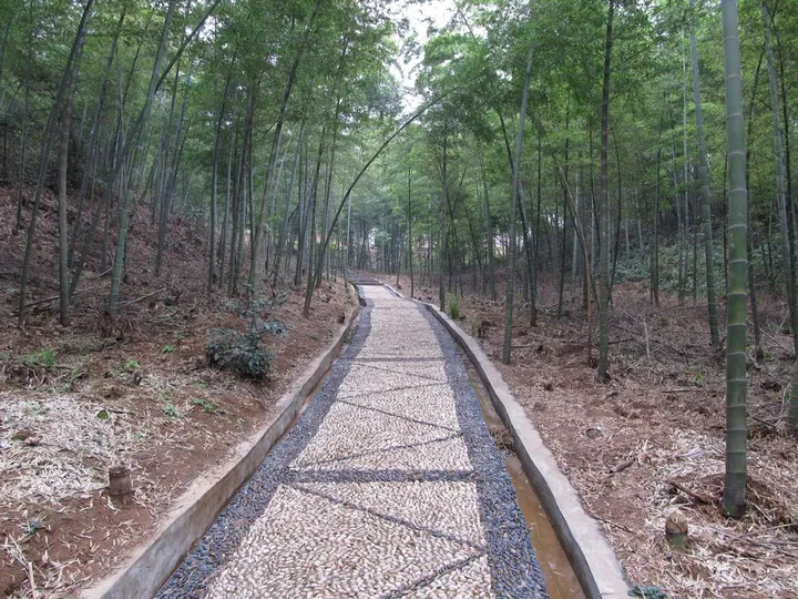 A stone footpath through the bamboo forest at Cai Lun Zhu Hai (Cai Lun Bamboo Sea), Leiyang ·
 Plan your visit
Getting there
Leiyang is about 60 km in a straight line from central Hengyang. Search for 耒阳市 in a map app to find stations and your accommodation.
Where to stay →Build your route
Start with Cai Lun Bamboo Sea. The linked place guides have entrance and visit details.
Continue with Hengyang →More in Hengyang
Sources & geographic information
Administrative names and parent areas: Official geographic directory · Reference date 2026-09-06.
Some facts checked against 耒阳市 — Wikipedia contributors, CC BY-SA 4.0.
Photo: Cai Lun Bamboo Sea · Yin沩 · CC BY-SA 3.0. Full frame retained; proportionally resized and converted to WebP. No retouching or changes to the photographed subject. Card displays may crop the view.

Map data © OpenStreetMap contributors. Pins mark approximate centres, not entrances or boundaries.